
 Česky
Česky Deutsch


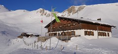


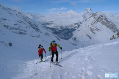
The Sesvenna Hütte is the only chalet in a small part of the Alps - the Sesvennagroup. The Hut is close to the border between Italy, Switzerland and Austria. Sesvenna hut is easy to reach from the parking lot in Schlinig / Slingia. The Sesvennahütte is an skimo area that is characterized by the variability of the surrounding ski tours. The ski tour on Piz Cristanas and Piz Sesvenna with the crest finale is clearly highlighted. The Schadler (north slope) and the south slopes of Piz Rassas offer great freeride experiences. Sesvenna Hut is a very cozy mountain hut with excellent south tyrolean cuisine.
Ski tours around Hut Sesvenna Hütte
- Country
- Italy
- Montains
- Sesvenna Alps
- Open (winter)
- early February - mid April
- Beds
- 78
- Winterraum
- open, 6 beds
- Shortening of access (cableway, lift, taxi, snowcat...)
- no
- Luggage transport
- no
- Card Pay
- no
- Shower
- yes
- Wifi
- no
- UTM / CH1903 x ("longitude" E/W)
- 32T 609676
- UTM / CH1903 y ("latitude" N/S)
- 5176681
- GPX access to hut (waipoints, track)
- Sesvenna-Hut_access_Schlinig.gpx
- GPX access to hut (track only)
- Sesvenna-Hut_access_TRK.gpx
- Map
- Vinschgau Sesvenna, Tabacco Nr. 044, 1:25000 Vinschgauer Oberland, Tabacco Nr. 043, 1:25000
- Guides
- Skitouren in Dreiländereck / Tappeiner, deutsch
- Phone (hut)
- +39 0473 830 234
- Phone (valley)
- +39 379 134 2237
- Cell phone
- -
- Mobile Signal
- yes
- Web
- sesvenna.com
- info@sesvenna.com
- Owner of hut
- AVS - Alpenverein Südtirol
- Schutzhütte Sesvenna
- Reservation
- phone, online form
- Online reservation
- sesvenna.com
- Start Point
- Schlinig - Slingia
- UTM / CH1903 x ("longitude" E/W)
- 32T 612561
- UTM / CH1903 y ("latitude" N/S)
- 5173593
- Altitude
- 1740 m
- Ascent (height difference)
- 550 m
- Time of Access
- 1,5-2,5 h
- Shortening lift
- no
- Avalanche danger
- lawinen.report lawine.at
- Weather
- Sesvennahütte, meteoblue.com Watles, snowforecast.com Belpiano / Schöneben, snow-forecast.com Wetter Südtirol Piz Sesvenna 3204m / mountain-forecast.com Piz Cristanas 3092m / mountain-forecast.com Alpenvereinswetter Wetterbericht Vinschgau ZAMG - Austria App Wetter Südtirol
- Snow report
- Watles / bergfex.it Belpiano / Schöneben, snow-forecast.com / snow-forecast.com Belpiano / Schöneben, onthesnow.com Watles, skiresort.info
- Webcams
- Watles - ski resort 2150 m Belpiano / Schöneben) - ski resort, 9 webcams
- Region
- Vinschgau - Val Venosta Suedtirolerland.it - Schlinig Ferienregion Vinschgau
- Public traffic
- Südtirol bus Südtirol - all public transport
- Skiresort nearby
- Watles Belpiano - Schöneben Nauders (AUT)
- Other links
- Südtirol Tourism south-tirol.com / accommodations suedtirolerland.it
hut Sesvenna Hütte - Reviews
There are no reviews in this section yet. Click the Add Review button to add first review.
Best ski tours in Italy by skitour.guru
-

Glockhauser 3201 m
Langtauferer Tal / Vallelunga - Melag Ötztaler Alpen Italy
- Length of ascent5,5 km
- ascent1085 m
- duration3-4,5 h
- Fitness difficulty ♦♦◊◊
- Technical difficulty ♦♦◊◊
Skialpinistická túra na Glockhauser není příliš náročná a nabízí vynikající výhledy na západní část Ötztálských Alp - Weißkugel, Bärenbartkögel, Falalbenairspitze atd. Zajímavostí je odlišná trasa výstupu a sjezdu Sjezd jihovýchodně situovaným kotlem Schönkar je zejména při firnu skvělým zážitkem. Pozor na laviny při větším množství nového sněhu.

-
Croda Ciamin (Day 4 H.R. Dolomiten Südtirol) 1422 m
Lavarella Ücia / Rifugio Lavarella Dolomiti Italy
- Length of ascent2 km
- ascent780 m
- duration5-7 h
- Fitness difficulty ♦♦◊◊
- Technical difficulty ♦♦♦◊
CRODA CIAMIN (Day 4 H.R. Dolomiten Südtirol) is a nice peak available from Lavarella, Fanes and Pederü. The enjoyment is the downhill on the groove Gran Vallon
-

Kleine Gaisl - Croda Rossa Piccada 2859 m
Pragser Dolomiten - Dolomiti di Braies Dolomiti Italy
- Length of ascent10,5 km
- ascent1690 m
- duration6-8 h
- Fitness difficulty ♦♦♦♦
- Technical difficulty ♦♦♦◊
Skialpinistická túra na Kleine Gaisl (italsky Croda Rossa Piccada) patří k těm náročnějším. Jak kvůli délce, tak i lavinovému nebezpečí za severních svazích. Členitým terénem přes sedlo Fossesser Ridl. Nejobtížnější je vystoupat na hřeben pod Roten Wand a pak po plochém hřebenu na vrchol. Odměnou je impozantní výhled na celé východní Dolomity i mohutné skály Hohe Gaisl. Z vrcholu je vidět sjezdová linie z Passo Colfiedo. Sjezd kopíruje výstupovou trasu.