Česky
Česky Deutsch


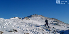


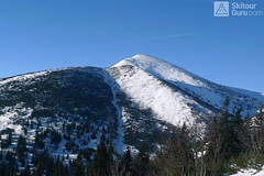
Ski tour on Chleb is easy. From Chata pod Chlebom on the way to the Snilovske sedlo saddle. Further along the ridge to the summit. The best descent is usual from the saddle Hromovské sedlo. After almost 300 m of descent, turn right and then to the refuge Chata pod Chlebom.
Peak
- Country
- Slovakia
- Montains
- Malá Fatra
- Tags
- Chata pod Chlebom Mala Fatra Slovakia
- Hut
- Chata pod Chlebom
- UTM / CH1903 x ("longitude" E/W)
- 34U 358023
- UTM / CH1903 y ("latitude" N/S)
- 5450152
Start point
- Start Point
- Chata pod Chlebom
- Altitude
- 1423 m
- UTM / CH1903 x ("longitude" E/W)
- 19°02.95890'
- UTM / CH1903 y ("latitude" N/S)
- 49°10.86492'
- village, valley
- Váh valley
- cableway / lift
- yes, from the valley Vrátna dolina
Conditions
- Avalanche danger
- Stredisko lavinovej prevencie HZS
- Weather
- Chata pod Chlebom / Metoblue.com Chata pod Chlebom / yr.no HZS / Mountain Rescue login"user" - meteo station "Snilovské sedlo" Vrátna / snow-forecast.com Velký Kriváň 1709 m / mountain-forecast.com Velký Rozsutec 1610 m / mountain-forecast.com Slovensko / shmu.sk Slovensko - meteograms / shmu.sk
- Snow report
- Vrátna / snow-forecast.com Slovensko / meteo.sk Vrátna / onthesnow.com Vrátna / bergfex.at
- Webcams
- Chleb, Vrátna, Poludňový Grúň Chata pod Chlebom
Ski tour map on Chleb


 bivakovací nouzová chata
  cepín a mačky potřeba
 exponovaný, obtížný terén
 horská chata
 hôtel, penzion
 lanovka, vlek
 lavinové nebezpečí, svah > 30°
 ledovcové trhliny
 lehká túra
 mimořádně obtížná túra
 mírně obtížná túra
 obtížná túra
 parkoviště
 přístup k chatě
 restaurace
 sedlo
sedlo sjezd
sjezd skidepo
 vrchol
 výstup
 začátek ledovce
- bivouac, winter room
- crampons & ice axe necessary
- exposed, difficulty terrain
- mountain hut, refuge
- hotel, pension
- cableway, skilift
- avalanche danger, slope > 30°
- glacier cracks
- little difficult tour
- extremely difficult tour
- rather difficult tour
- difficult tour
- parking
- hut acces
- restaurant
- col, pass, saddle
- descent
- skidepot
- peak, summit
- ascent
- glacier beginning
- biwak, winterraum
- steigeisen & pickel erforderlich
- ausgesetzt, schwierige gelände
- berghütte
- hotel, pension
- seilbahn, skilift
- lawinengefahr, hangneigung > 30°
- gletscherspalten
- wenig schwierige tour
- äusserst schwierige tour
- ziemlich schwierige tour
- schwierige tour
- parkplatz
- zugang zur hütte
- restaurant
- sattel, joch, pass
- abfahrt
- skidepot
- gipfel
- aufsieg
- gletscher anfang
- bivacco, locale invernale
- ramponi & piccozza necessari
- esposto, terreno difficolt?
- rifugio, capanna
- alberghi, pensione
- funivia, seggiovia
- pericolo di valanghe, pendenza > 30°
- crepe glacier
- tour piccolo difficile
- tour estremamente difficile
- tour piuttosto difficile
- escursioni difficili
- parcheggio
- accesso capanna
- ristorante
- col, sella, passo, forcella
- discesa
- sci deposito
- picco, vertice, piz
- salita
- inizio ghiacciaio
- bivouac, local d'hiver
- crampons & piolet nécessaire
- exposée, difficulté du terrain
- cabane de montagne, refuge
- hôtel, pension
- téléphérique, téléski
- danger d'avalanche, pente > 30°
- crevasse du glacier
- peu difficile tour
- extr?mement difficile tournée
- assez difficile tour
- difficile tournée
- parking
- acces cabane
- restaurant
- col, selle
- descente
- skis dépôt
- pic, sommet
- ascension
- début glacier
- < 20°
- 20° - 25°
- 25° - 30°
- 30° - 35°
- 35° - 40°
- > 40°
Current weather conditions in the tour area
Planning of ski tour
- Fitness difficulty
-
- ♦◊◊◊
- Technical difficulty
-
- ♦◊◊◊
- best time for this tour
- all winter
- Glacier
- No
- Map
- Malá Fatra, TatraPlan Nr. 2506, 1:25.000 Malá Fatra, 1:50000, Nr. 110, VKÚ Harmanec
- Guides
- Výber lyžiarskych a skilpinistických túr
About Ski tour
- Time difficulty
- Ascent (height difference)
- 225 m
- Lenght of ascent
- 1,5 km
- Descent (height difference)
- 300 m
- Total Lenght of tour
- 3 km
- Total time of the tour
- 1-1,5 h
- Elevation Range
- 1423 - 1645 m
- Principal Aspect
- S, SE S-south, N-north, W-west, E-east
Download
- GPX (track only)
- Chleb_TRK.gpx best for display on a detailed topographical map (mapy.cz) or in apps for smartphones (Locus, Garmin Connect, etc.)
- GPX (waipoints, track)
- Chleb1645_ChPChlebom_skitour.gpx great for uploading in GPS device
- KML (with POI)
- Chleb1645m_skitour.kml for viewing in the Google Earth 3D map application, which you can install on your PC
Video of tour on Chleb
Important warning: The information and data provided on Skitour.Guru has been compiled with great care. The use of all information is at your own risk. Personal experience and knowledge of a current state of slope are very important in addition to generally useful informations for the risk assessment. Itineraries of ski tours may vary from the ones mentioned above depending on the current snow conditions or terrain changes (eg glacier). Careful planning and assessment of the avalanche danger for specific slopes before each ski tour is crucial. The pictograms in the tour map mark the usual key points. In general, GPS device is a helpful friend, but in the end, it is always the person, who decides over the route line in the terrain. The height profile shows us the slope. The cited duration data are indicated, rather intended for slower ski tourers and include the movement time without pauses.