
 Česky
Česky Deutsch


Haute Route
Best ski tours
-
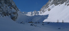
Felskarspitze 2506 m
Zederhaus - Kirchenwirt Niedere Tauern Austria
- Length of ascent6,5 km
- ascent1195 m
- duration4-5,5 h
- Fitness difficulty ♦♦♦◊
- Technical difficulty ♦♦◊◊
Skialpová túra na Felskarspitz je skvělá. Dolní polovina je v lese s možností hezkého sjezdu, horní čás je ve znamení ledovcového karu a mohutné jihovýchodní stěny Weissecku. Sjezd většinou závětrnou kotlinou, sklon tak akorát a místo pro všechny. Díky severní expozici často prašan. Pokud jsou dobré podmínky, vyplatí se z vrcholu pokračovat na Weisseck a prožít fantastický, dlouhý sjezd.

-

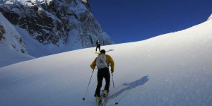
Tour du Ciel - day 3 3649 m
Cabane du Mountet Walliser Alpen / Alpes valaisannes Switzerland
- Length of ascent10,5 km
- ascent2420 m
- duration10-12 h
- Fitness difficulty ♦♦♦♦
- Technical difficulty ♦♦♦♦
A very long and demanding, royal stage of this Haute Route. In my opinion, the most impressive stage of all multi-day Alpine crossings. Due to the elevation gain and time required, it’s worth considering splitting the stage into two days with an overnight stay in Zinal. The long, exposed ridge to the summit requires rope protection depending on conditions. The descent is fantastically long, but caution is needed – there are large crevasses. This ski tour is only recommended in stable weather; in poor conditions, it’s advisable to bypass the Blanc de Moming via the Glacier de Zinal and ascend directly to the Cabane de Tracuit.
-

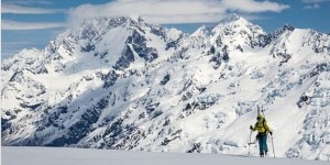
Hohe Wilde / Hochwilde 3461 m
Langtalereckhütte Ötztal Alps / Alpi Venoste Austria
- Length of ascent8 km
- ascent1040 m
- duration6-8 h
- Fitness difficulty ♦♦♦◊
- Technical difficulty ♦♦♦♦
Hohe Wilde (Langtalereck Hütte, Ötztaler Alpen) is a distinctive mountain at the end of the Langtaler Ferner glacier with a challenging finisch to the summit.
Information about Skitours and Mountain huts
-
 skitours and mountain huts

5 Skitouren in Kärntens Bergen
Bergwelten.com bergwelten.com 12. 01. 2019 German
n den Nordalpen bleibt die Lawinensituation weiterhin angespannt (Lawinenwarnstufe 4 bis 5). Doch südlich des Alpenhhautpkamms, in den Gailtaler-, Lavanttaler und Karnischen Alpen sowie den Karawanken, herrschen momentan gute Tourenbedingungen. Wir stellen euch 5 Skitouren in Kärnten vor.
tags: Kärnten
-
 skitours and mountain huts

New Zealand Ski Touring Experience 2018
wildsnow.com Julia Dubinina 5. 11. 2018 English
Our NZ adventure began with 20+ hours of travel, learning to drive on the wrong side of the road in a giant camper van, consuming delicious meat pies, visiting friends, a bit of sleep, and lots of sheep...
tags: New Zealand
-
 skitours and mountain huts

Coast Mountain Traverse Complete!
backcountryskiingcanada.com Backcountryskiingcanada.com 19. 01. 2018 English
I understand that's it's officially summer today and skiing might be in the summer storage bin on the back burner of your mind but the Coast mountain epic has finally been completed. If you haven't been following this epic saga here's the nitty gritty of what you need to know.
-
 skitours and mountain huts
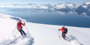
Vom Gipfel bis zum Fjord: Skitouren in Nordnorwegen
Bergwelten.com Bergwelten.com 1. 12. 2017 German
Unverspurte Pulverschneehänge, Abfahrten vom Gipfel bis zum Fjord und dann mit dem Boot zurück zur Lodge wo der Whirlpool...
tags: skitouring
-
 skitours and mountain huts
Ski Norway
tetongravity.com Robert Pursell 20. 11. 2017 English
The Way It Was Always Meant To Be Skied: By Train