Česky
Česky Deutsch


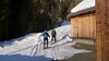
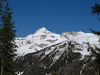


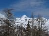

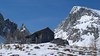

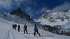


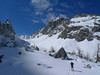


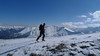
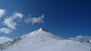

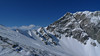
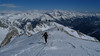
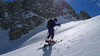
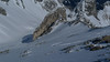


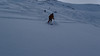
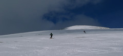
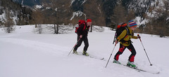
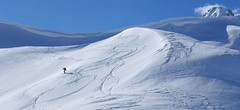
Skialpová túra na Felskarspitz je skvělá. Dolní polovina je v lese s možností hezkého sjezdu, horní čás je ve znamení ledovcového karu a mohutné jihovýchodní stěny Weissecku. Sjezd většinou závětrnou kotlinou, sklon tak akorát a místo pro všechny. Díky severní expozici často prašan. Pokud jsou dobré podmínky, vyplatí se z vrcholu pokračovat na Weisseck a prožít fantastický, dlouhý sjezd.
Peak
- Country
- Austria
- Montains
- Niedere Tauern
- Tags
- Austria Lungau Austria Salzburgland skialpinism ski touring Zederhaustal
- Hut
- Zederhaus - Kirchenwirt
- UTM / CH1903 x ("longitude" E/W)
- 33T 378321
- UTM / CH1903 y ("latitude" N/S)
- 5224078
Start point
- Start Point
- Zederhaus - Kirchenwirt
- Altitude
- 1200 m
- UTM / CH1903 x ("longitude" E/W)
- 33T 386861
- UTM / CH1903 y ("latitude" N/S)
- 5223212
Conditions
- Avalanche danger
- Lawine Salzburg
- Weather
- Zederhaus / Meteoblue.com Weisseck / Meteoblue.com Hafner 3076m / mountain-forecast.com Ostalpen / alpenverein.at Nieder Tauern Bergwetter 2 days / orf.at Salzburgland / orf.at Austria / ZAMG Skiwetter - Obertauern
- Snow report
- Meteovista - Zederhaus www.snow-forecast.com - Katschberg-Aineck
- Webcams
- Zederhaus - Autobahn Speireck - St. Michael im Lungau Katschberg
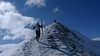
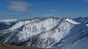
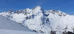
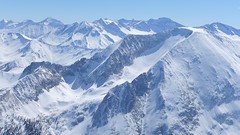
Ski tour map on Felskarspitze


 bivakovací nouzová chata
  cepín a mačky potřeba
 exponovaný, obtížný terén
 horská chata
 hôtel, penzion
 lanovka, vlek
 lavinové nebezpečí, svah > 30°
 ledovcové trhliny
 lehká túra
 mimořádně obtížná túra
 mírně obtížná túra
 obtížná túra
 parkoviště
 přístup k chatě
 restaurace
 sedlo
sedlo sjezd
sjezd skidepo
 vrchol
 výstup
 začátek ledovce
- bivouac, winter room
- crampons & ice axe necessary
- exposed, difficulty terrain
- mountain hut, refuge
- hotel, pension
- cableway, skilift
- avalanche danger, slope > 30°
- glacier cracks
- little difficult tour
- extremely difficult tour
- rather difficult tour
- difficult tour
- parking
- hut acces
- restaurant
- col, pass, saddle
- descent
- skidepot
- peak, summit
- ascent
- glacier beginning
- biwak, winterraum
- steigeisen & pickel erforderlich
- ausgesetzt, schwierige gelände
- berghütte
- hotel, pension
- seilbahn, skilift
- lawinengefahr, hangneigung > 30°
- gletscherspalten
- wenig schwierige tour
- äusserst schwierige tour
- ziemlich schwierige tour
- schwierige tour
- parkplatz
- zugang zur hütte
- restaurant
- sattel, joch, pass
- abfahrt
- skidepot
- gipfel
- aufsieg
- gletscher anfang
- bivacco, locale invernale
- ramponi & piccozza necessari
- esposto, terreno difficolt?
- rifugio, capanna
- alberghi, pensione
- funivia, seggiovia
- pericolo di valanghe, pendenza > 30°
- crepe glacier
- tour piccolo difficile
- tour estremamente difficile
- tour piuttosto difficile
- escursioni difficili
- parcheggio
- accesso capanna
- ristorante
- col, sella, passo, forcella
- discesa
- sci deposito
- picco, vertice, piz
- salita
- inizio ghiacciaio
- bivouac, local d'hiver
- crampons & piolet nécessaire
- exposée, difficulté du terrain
- cabane de montagne, refuge
- hôtel, pension
- téléphérique, téléski
- danger d'avalanche, pente > 30°
- crevasse du glacier
- peu difficile tour
- extr?mement difficile tournée
- assez difficile tour
- difficile tournée
- parking
- acces cabane
- restaurant
- col, selle
- descente
- skis dépôt
- pic, sommet
- ascension
- début glacier
- < 20°
- 20° - 25°
- 25° - 30°
- 30° - 35°
- 35° - 40°
- > 40°
Current weather conditions in the tour area
Planning of ski tour
- Fitness difficulty
-
- ♦♦♦◊
- Technical difficulty
-
- ♦♦◊◊
- best time for this tour
- Februar-March
- Glacier
- No
- Map
- Niedere Tauern, OEAV 1:25000, Nr. 45/II
- Guides
- SCHITOURENFÜHRER ÖSTERREICH Band I / Alpinverlag, DE SCHITOUREN-ATLAS ÖSTERREICH OST, Schall-Verlag
About Ski tour
- Time difficulty
- Ascent (height difference)
- 1195 m
- Lenght of ascent
- 6,5 km
- Descent (height difference)
- 1195 m
- Total Lenght of tour
- 12,5 km
- Total time of the tour
- 4-5,5 h
- Elevation Range
- 1350 - 2506 m
- Principal Aspect
- N, NE S-south, N-north, W-west, E-east
Download
- GPX (track only)
- Felskarspitze-TRK.gpx best for display on a detailed topographical map (mapy.cz) or in apps for smartphones (Locus, Garmin Connect, etc.)
- GPX (waipoints, track)
- Felskarspitze_Zederhaus_skitour.gpx great for uploading in GPS device
- KML (with POI)
- Felskarspitze 2506m_skitour.kml for viewing in the Google Earth 3D map application, which you can install on your PC
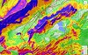
Current avalanche potential on tour - Felskarspitze

tour Felskarspitze - Reviews
There are no reviews in this section yet. Click the Add Review button to add first review.
Ski tours around Hut Zederhaus - Kirchenwirt, in mountains Niedere Tauern, Austria
-
Seeköpfl 2222 m
Zederhaus - Kirchenwirt Niedere Tauern Austria
- Length of ascent6 km
- ascent1000 m
- duration3-4,5 h
- Fitness difficulty ♦♦◊◊
- Technical difficulty ♦◊◊◊
Túra na vrchol Seeköpfl patří mezi ty nejlehčí a hodí se na dny s ne zrovna ideálním počasím. Po jednoduché trase po lesní cestěk hranici lesa, následně stoupání lesem a pak po širokém, otevřeném svahu na nevýrazný vrchol. Sjezd buď po trase výstupu nebo po severních svazích a cestách na parkoviště Wald. V případě této volby je nutno mezi parkovišti dojít pěšky nebo stopem.

-
Mosermandl 2677 m
Zederhaus - Kirchenwirt Niedere Tauern Austria
- Length of ascent8,5 km
- ascent1405 m
- duration6,5-7 h
- Fitness difficulty ♦♦♦◊
- Technical difficulty ♦♦♦◊
Gross Mosermandl je spolu s Weisseckem absolutním highlightem oblasti Zederhaustal v regionu Salzburger Lungau. Z parkoviště Wald se stoupá nejprve mírně údolím, pak po lesní cestě nahoru nad hranici lesa. Následují už svahy se sklonem 30 stupňů a větším. Nejobtížnější pasáž je v závěru výstupu, většinou bez lyží, v mačkách. Sjezd kopíruje trasu výstupu. Při dostatku času a sil je možné jít do Waldu přes kopec Schöpfling a místo cesty údolím si užít hezký sjezd.
-
Weisseck 2711 m
Zederhaus - Kirchenwirt Niedere Tauern Austria
- Length of ascent7 km
- ascent1450 m
- duration5-7 h
- Fitness difficulty ♦♦♦◊
- Technical difficulty ♦♦♦◊
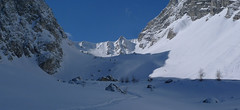
Ski tour to the impressive Weisseck. In good conditions, a spectacular Ödenkar boiler descent is offered. If we don't climb to the Weisseck, the beautiful Ferskarspitze is on the way. Through the forest you reach the valley "In hell" (In der Hölle) - on one side of the rock towers, on the other side of the wall of Weisseck. Enter the Ödenkar from the upper plateau with the summit cross and watch out for snow guards and a very steep start.
-
Schöpfing 2139 m
Zederhaus - Kirchenwirt Niedere Tauern Austria
- Length of ascent5,5 km
- ascent900 m
- duration3-4,5 h
- Fitness difficulty ♦♦◊◊
- Technical difficulty ♦◊◊◊
Túra na Schöpfing je snadná a hodí se pro den horšího počasí. Slibuje výborný výhled na Weisseck a Mosermandl. Sjezd západním svahem bývá často s prašanem, hlavně v první části zimy.