
 Česky
Česky Deutsch


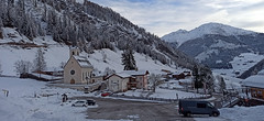


Kalkstein is located at the end of the remote Villgratental. A steep road (in the snow, only accessible with snow chains) leads to the large parking lot next to the rustic inn Badl Alm. The former customs village mainly benefits from the interest of ski tourers, with six destinations to choose from, mostly of medium difficulty and generally with a lower avalanche risk. Choose from tours to the peaks of Marchkinkele (2545 m), Kreuzspitze (2613 m), Toblacher Pfannhorn (2663 m), Gaishörndl (2615 m), and Pürglesgungge.
Tours starting from hut
Ski tours around Hut Kalkstein - Villgratental
-

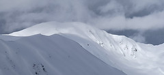
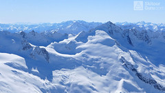
Gaishörndl 2604 m
Kalkstein - Villgratental Villgratner Berge - Deferegger Alpen Austria
- Length of ascent4,5 km
- ascent980 m
- duration4-5,5 h
- Fitness difficulty ♦♦◊◊
- Technical difficulty ♦♦◊◊
Gaishörndl je často navštěvovaná hraniční hora v oblasti Kalkstein. Túru lze absolvovat téměř každý den po celou zimu. Optimální sklon sjezdu a díky své jihovýchodní poloze také krásná firnová túra. Výhledy na Dolomity a údolí Pustertal až k Toblachu.

-

Marchkinkele from Kalkstein 2545 m
Kalkstein - Villgratental Villgratner Berge - Deferegger Alpen Austria
- Length of ascent4 km
- ascent875 m
- duration3,5-5 h
- Fitness difficulty ♦♦◊◊
- Technical difficulty ♦♦◊◊
Skialpová túra Marchkinkele je jednou z tras ve Villgratentalu, která je poměrně často ohrožena lavinami. Díky své severní poloze však prachový sníh vydrží dlouho do jara a podmínky jsou obvykle ideální. Od sedla Gisser Törl nahoru je sníh často ovlivňován větrem.
-
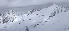
Toblacher Pfannhorn 2663 m
Kalkstein - Villgratental Villgratner Berge - Deferegger Alpen Austria
- Length of ascent5,5 km
- ascent1040 m
- duration4-5,5 h
- Fitness difficulty ♦♦◊◊
- Technical difficulty ♦♦◊◊
Vrchol Toblacher Pfannhorn stojí za to nejen kvůli fantastickému výhledu na Dolomity s Tre Cime, ale také kvůli výhledům na Lienzské Dolomity nebo hlavní alpský hřeben. Poněkud strmější sjezd po vrcholovém hřebenu je při dostatku sněhu velmi atraktivní.
-

Pürglesgungge 2500 m
Kalkstein - Villgratental Villgratner Berge - Deferegger Alpen Austria
- Length of ascent4 km
- ascent890 m
- duration4-5,5 h
- Fitness difficulty ♦♦◊◊
- Technical difficulty ♦◊◊◊
Skialpová túra na Pürglesgungge je nádherná nad hranicí lesa. Krásné výhledy dolů do údolí Villgratental a do protějšího údolí Marchental s výstupem na Marchkinkele. Rozsáhlý terén nabízí za bezpečných podmínek skvělý sjezd do údolí Alfental.
-

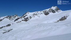
Kreuzspitze 2624 m
Kalkstein - Villgratental Villgratner Berge - Deferegger Alpen Austria
- Length of ascent5,5 km
- ascent955 m
- duration3,5-5 h
- Fitness difficulty ♦♦◊◊
- Technical difficulty ♦♦◊◊
Túra na Kreuzspitze patří k nejoblíbenějším v oblasti Kalksteinu. Široký svah nabízí variabilitu sjezdové trasy. Od mohtného kříže na vrcholu je parádní výhled.
- Country
- Austria
- Montains
- Villgratner Berge - Deferegger Alpen
- Open (winter)
- everyday
- Beds
- 0
- Winterraum
- Shortening of access (cableway, lift, taxi, snowcat...)
- accessible by car
- UTM / CH1903 x ("longitude" E/W)
- 33T 295382
- UTM / CH1903 y ("latitude" N/S)
- 5186922
- GPX all tours from the hut
- Kalkstein_ALL_skitours.gpx
- Map
- Villgratental- Sillian, 1:25.000, Tabacco 073 Innervillgraten, 1:25.000 BEV-Karte 3102-West
- Guides
- Skitourenführer Tirol / Alpinverlag, deutsch Skitouren in Osttirol und Oberkärnten: Hohe Tauern / Tyrolia / deutsch Tiroler Skitouren Handbuch / Michael Wagner Verlag / deutsch Pustertal / Bergverlag Rother / deutsch SCHITOUREN-ATLAS ÖSTERREICH WEST / Schall Verlag / deutsch
- Phone (hut)
- -
- Phone (valley)
- -
- Cell phone
- -
- Mobile Signal
- yes
- Web
- Tourismusinformation Innervillgraten
- villgratental@osttirol.com
- Owner of hut
- -
- Osttirol - Dein BergTirol
- Avalanche danger
- Lawine Tirol
- Weather
- Innervillgraten 1530 m / meteoblue.com Thurntaler 2408 m / meteoblue.com Helm / Monte Helmo / mountain-forecast.com Bergwetter Tirol 2 days Tirol / ORF.at Tirol - Austria ZAMG
- Snow report
- Sillian / snow-forecast.com St. Jakob Defereggental / snow-forecast.com Sillian / onthesnow.com St. Jakob Defereggental / onthesnow.com Sillian / bergfex.at St. Jakob Defereggental / bergfex.at
- Webcams
- Innervillgraten - Ort 1402 m Kalkstein parkplatz 1640 m Kreuzspitze 2614 m Sillian - Bergstation 6-Bahn 2408 m Bergstation Ausservillgraten 2200 m St. Jakob Defereggental / bergfex.at
- Region
- Osttirol.com
- Public traffic
- Bus - Postbus.at Train - oebb.at
- Skiresort nearby
- Sillian - Hochpustertal St. Jakob in Defferegental Drei Zinnen / Tre Cime
- Other links
- booking.com airbnb.com Austria Tourism
hut Kalkstein - Villgratental - Reviews
There are no reviews in this section yet. Click the Add Review button to add first review.
Best ski tours in mountains Villgratner Berge - Deferegger Alpen, Austria
-

Rotes Kinkele 2754 m
Innervillgraten Villgratner Berge - Deferegger Alpen Austria
- Length of ascent5,5 km
- ascent1065 m
- duration4-6 h
- Fitness difficulty ♦♦◊◊
- Technical difficulty ♦♦♦◊
Rotes Kinkele je výborná túra uprostřed oblasti a tak poskytuje z vrcholu výhled na všechny zásadní kopce oblasti. Po lesních cestách na malebný Kamelisenalm a pak vlevo od potoka stále nahoru. Na počátku dlouhého hřebenu na vrchol je potřeba vyhodnotit, zda bude schůdný na pásech nebo v mačkách. Výšlap na pyramidu k vrcholovému kříži je snadný. Sjezd kopíruje trasu výstupu
-
Grosses Degenhorn 2937 m
Innervillgraten Villgratner Berge - Deferegger Alpen Austria
- Length of ascent11 km
- ascent1470 m
- duration7,5-9,5 h
- Fitness difficulty ♦♦♦◊
- Technical difficulty ♦♦◊◊
Skialpová túra na Grosses Degenhorn míří na jeden z nejvyšších vrcholů pohoří Villgraten, a proto je z něj skvělý výhled. Nádherný firnový sjezd si musíte zasloužit dlouhým výstupem přes údolí Arntal. Díky své výšší poloze je možné túru podniknout i v květnu. V jarních podmínkách je nutné počítat s dlouhou chůzí bez lyží údolím Arntal.
-

Hochstein 2827 m
Innervillgraten Villgratner Berge - Deferegger Alpen Austria
- Length of ascent6,5 km
- ascent1150 m
- duration4-6 h
- Fitness difficulty ♦♦♦◊
- Technical difficulty ♦♦◊◊
Skialpová túra na Hochstein je členitá a zajímavá. Za almem Kamelisenalm se stoupá mírným táhlým západním svahem do sedla Öwelenke. Krátký sjezd na pásech a hned doleva traverzem směrem k jezeru (nesjíždět až dolů k potoku). Nejprudší výstup túry je z kotliny nad jezerem. Závěr výstupu na vrchol vede táhlým mírným svahem. Sjezd po trse výstupu. Alternativou je za dobrých podmínek přelezení hřebínku z posledního sedla do sektoru trasy na Rotes Kinkele a po dosažení vrcholu sjíždet trasou z Rotes Kinkele, která je sjezdařsky zajímavější.
Best ski tours in Austria by skitour.guru
-
Dreiherrnspitze 3499 m
Essener-Rostocker Hütte Venedigergruppe - Hohe Tauern Austria
- Length of ascent8,6 km
- ascent1430 m
- duration9-11 h
- Fitness difficulty ♦♦♦♦
- Technical difficulty ♦♦♦◊
The Dreiherrnspitze is a spectacular, complex and challenging glacier ski tour. Especially difficult is its length, glacial cracks and terrain break at the end. First, it is easy to climb glacier the Südl. Malhamkees to Regentörl saddle. After a short downhill northwards to the Umbalkees Glacier, the traverse between the cracks and then to the Althauskees. Relatively steep slope to difficult terrain break (depending on snow conditions). After overcoming it, there is only 200 high meters in easy terrain. Downhill same track as ascent.
-

Königstuhl 2336 m
Innerkrems - Mehrlhütte Nockberge Austria
- Length of ascent6,5 km
- ascent840 m
- duration4,5-6 h
- Fitness difficulty ♦♦◊◊
- Technical difficulty ♦♦◊◊
Skialpová túra na Königstuhl je nejlepší trasou v této oblasti, hlavně díky panoramatům na pohoří Nockberge a na Niedere Tauern (Nízké Taury). Snazší výstup vede údolím potoka Krems a výše podél jezera Rosaninsee do sedla Königstuhlscharte. Odtud po plochém západním svahu na vrchol. Sjezd po trase výstupu. Za příznivé lavinové situace je mnohem atraktivnější panoramatická hřebenovka přes Sauereggnock, Vogelsangberg a Seenock. Pozor, místy s exponovanými úseky. Pokud je dobrý sníh, sjeďte z vrcholu Seenock do kotle k jezeru a pokračujte na pásech do sedla a na vrchol. Uvedené údaje platí pro okružní hřebenovou variantu.
-
Schlieferspitze 3289 m
Kürsinger Hütte Venedigergruppe - Hohe Tauern Austria
- Length of ascent7,5 km
- ascent1050 m
- duration5-6,5 h
- Fitness difficulty ♦♦♦◊
- Technical difficulty ♦♦♦◊
Relatively demanding glacier ski tour on 3289 m Schlieferspitze leads glacial terrain. To stay on Kürsinger Hut fits is Schlieferspitze ideal tour for the last day. After ascent to descent the eastern slopes and valleys Sulzbachtal the parking lot. When staying overnight at Postalm is actually the only option for the ascent.