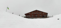
The Marteller Hütte is the higher of the two huts above the Martelltal. The South Tyrolean cuisine is famous. Cozy rooms and a mattress dormitory are available. The hut is an excellent starting point for tours to Cevedale, Cima Marmotta / Köllspitze, and Zufallspitze. Before ascending Madritschspitze, you must descend into the valley to the Plima stream. Sleeping bag liners are mandatory for overnight stays.
Tours starting from hut
Ski tours around Hut Marteller Hütte
- Country
- Italy
- Montains
- Ortles
- Open (winter)
- mid-February - April
- Beds
- 59
- Winterraum
- yes, 10 beds, without cooking option
- Shortening of access (cableway, lift, taxi, snowcat...)
- no
- Luggage transport
- yes, by cablecar - must be ordered
- Card Pay
- no
- Shower
- yes
- Wifi
- yes,
- UTM / CH1903 x ("longitude" E/W)
- 32T 628450
- UTM / CH1903 y ("latitude" N/S)
- 5147602
- GPX access to hut (waipoints, track)
- MartellerHut_access.gpx
- GPX access to hut (track only)
- MartellerHut_access_TRK.gpx
- GPX all tours from the hut
- MartellerHut_ALL_skitours.gpx
- Map
- Ortler 1:25000, Tabacco Nr. 08
- Guides
- Skitouren im Dreiländereck (german) Skitouren in Südtirol (german) 60 Große Skitouren Ostalpen (german)
- Phone (hut)
- +39 (0)473 744790
- Phone (valley)
- -
- Cell phone
- +39 3355687235
- Mobile Signal
- yes
- Web
- martellerhuette.com
- martellerhuette@gmail.com
- Owner of hut
- AVS Südtirol
- AVS Marteller Hütte - Rifugio
- Reservation
- online
- Online reservation
- alpsonline.org
- Start Point
- Martelltalhütte Parking
- UTM / CH1903 x ("longitude" E/W)
- 32T 629406
- UTM / CH1903 y ("latitude" N/S)
- 5149586
- Altitude
- 2065 m
- Ascent (height difference)
- 545 m
- Time of Access
- 1,5 - 2 h
- Shortening lift
- no
- Avalanche danger
- Lawinen.report
- Weather
- Madritschspitze 3265 / meteoblue.com Martelltal 1265 m / meteoblue.com Cevedale 3769 / mountain-forecast.com Cevedale 3769 / meteoblue.com Suldenspitze 3376 / meteoblue.com Plattenspitze 3422 / meteoblue.com Wetter Südtirol
- Snow report
- Sulden / snow-forecast.com Sulden / onthesnow.com Sulden / bergfex.it Sulden / snow.cz
- Webcams
- Sulden Suldenspitze - Rif. Casati Passo Stelvio
- Region
- Vinschgau Martelltal Südtirol Alta Rezia
- Public traffic
- Local buses and trains
- Skiresort nearby
- Sulden / Solda
hut Marteller Hütte - Reviews
There are no reviews in this section yet. Click the Add Review button to add first review.
Best ski tours in Italy by skitour.guru
-

Kleine Gaisl - Croda Rossa Piccada 2859 m
Pragser Dolomiten - Dolomiti di Braies Dolomiti Italy
- Length of ascent10,5 km
- ascent1690 m
- duration6-8 h
- Fitness difficulty ♦♦♦♦
- Technical difficulty ♦♦♦◊
Skialpinistická túra na Kleine Gaisl (italsky Croda Rossa Piccada) patří k těm náročnějším. Jak kvůli délce, tak i lavinovému nebezpečí za severních svazích. Členitým terénem přes sedlo Fossesser Ridl. Nejobtížnější je vystoupat na hřeben pod Roten Wand a pak po plochém hřebenu na vrchol. Odměnou je impozantní výhled na celé východní Dolomity i mohutné skály Hohe Gaisl. Z vrcholu je vidět sjezdová linie z Passo Colfiedo. Sjezd kopíruje výstupovou trasu.

-

Cresta Bianca 2932 m
Dolomiti d´Ampezzo - Cortina, Cimabanche, Schluderbach Dolomiti Italy
- Length of ascent6 km
- ascent1380 m
- duration4-5,5 h
- Fitness difficulty ♦♦♦◊
- Technical difficulty ♦♦♦◊
Cresta Bianca je fantasická a náročná túra v masivu Cristallo. Po nástupu u hospůdky Cimabanche / Im Gemärk na rozhraní Südtirol a Veneto se stoupá členitým žlabem Val Pra de Vecia ve stínu severního svahu. Po dlouhém prudkém výstupu následuje traverz východním směrem do sedla Forcella Verde a dlouhý, ale přehledný výstup kotlem Graol de Forame až do sedla Forcella Granda. Odtud v mačkách na nedaleký vrchol Cresta Bianca. Pokud se na začátku sjezdu ze sedla budete držet vpravo, dostanete se do sedla s velkolepým výhledem na Tre Cime i kotel Val Fonda. Další sjezd kopíruje výstupovou trasu.

-

Monte Cristallo - Passo Cristallo 2806 m
Dolomiti d´Ampezzo - Cortina, Cimabanche, Schluderbach Dolomiti Italy
- Length of ascent6,5 km
- ascent1390 m
- duration4-5,5 h
- Fitness difficulty ♦♦♦◊
- Technical difficulty ♦♦♦♦
An challenging tour to the Passo/Forcelle Cristallo is a dream come true for everyone who loves thrilling descents. It begins just above the Schluderbach junction, and the most extensive variant finishes with a descent to Passo Tre Croci. Ascent starts along a shaded, gentle, rocky streambed leading into a grand alpine valley. You exit its narrow confines via a tight corridor through the rocks (on the left, to the north). Afterward, you cross a consistently steep, wide slope heading toward a choke point below the saddle.
Descent: Usually, you follow the same path used for the ascent. A very worthwhile alternative is descending on the south side. First, there’s a very steep section, which often has firn-like snow thanks to the sun. While skiing down the scree slopes, stay to the right, then go between the dwarf pines down to the saddle near Hotel Tre Croci (bus stop).


 Česky
Česky Deutsch


