
 Česky
Česky Deutsch


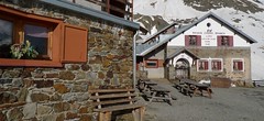


Rifugio Branca is located in the Ortles - Cevedale massif near the ski resort of Bormio - St. Catarina. The lodge is in the middle of a glacier area, ski tours from there to the peaks of Monte Cevedale, Pizzo Tresero, Punta San Matteo, Palon de la Mare and Monte Pasquale. Branca hut is easily accessible from the Forni car park.
Tours starting from hut
Ski tours around Hut Branca Rifugio
- Country
- Italy
- Montains
- Ortles
- Open (winter)
- March-May
- Beds
- 102
- Winterraum
- open, 8 beds
- Shortening of access (cableway, lift, taxi, snowcat...)
- no
- Luggage transport
- yes, must be ordered
- Card Pay
- yes
- Shower
- yes
- Wifi
- yes
- UTM / CH1903 x ("longitude" E/W)
- 32T 621726
- UTM / CH1903 y ("latitude" N/S)
- 5141356
- GPX access to hut (waipoints, track)
- Rif. Branca_access_skitour.gpx
- GPX access to hut (track only)
- Rif Branca_access_TRK.gpx
- GPX all tours from the hut
- Rif-Branca_ALL_skitours.gpx
- Map
- Ortler 1:25000, Tabacco Nr. 08
- Guides
- Scialpinismo tra Lombardia e Grigioni / Versante Sud, italiano 60 Große Skitouren Ostalpen
- Phone (hut)
- +39 0342 935 501
- Phone (valley)
- -
- Cell phone
- -
- Mobile Signal
- yes, good
- Web
- rifugiobranca.it
- info@rifugiobranca.it
- Owner of hut
- CAI Milano
- Rifugio Branca
- Start Point
- Hotel Forni parking
- UTM / CH1903 x ("longitude" E/W)
- 32T 621716
- UTM / CH1903 y ("latitude" N/S)
- 5141869
- Altitude
- 2140 m
- Ascent (height difference)
- 355 m
- Time of Access
- 1-1,5 h
- Shortening lift
- no
- Avalanche danger
- Aineva
- Weather
- Rif. Branca / meteoblue.com San Mateo 3678m / mountain-forecast.com Cevedale 3757m / mountain-forecast.com Gran Zebrú 3824m / mountain-forecast.com Pizzo Tresero 3594m / meteoblue.com Cevedale / meteoblue.com Suldenspitze / meteoblue.com Lombardia / arpalombardia.it
- Snow report
- St. Caterina / snow-forecast.com St. Caterina / onthesnow.com St. Caterina / bergfex.it St. Caterina / snow.cz
- Webcams
- Rif. Branca Bormio Cima Bianca
- Region
- Santa Caterina Valfurva Bormio Alta Rezia
- Public traffic
- Local buses and trains
- Skiresort nearby
- Santa Caterina Bormio
- Other links
- Parking Rifugio Forni
hut Branca Rifugio - Reviews
There are no reviews in this section yet. Click the Add Review button to add first review.
Best ski tours in Italy by skitour.guru
-

Seekofel - Croda del Becco 2810 m
Pragser Dolomiten - Dolomiti di Braies Dolomiti Italy
- Length of ascent8 km
- ascent1370 m
- duration5-6,5 h
- Fitness difficulty ♦♦♦◊
- Technical difficulty ♦♦◊◊
Skialpová túra na Seekofel (italsky Croda del Becco) od jezera Pragser Wildsee (Lago di Braies( slibuje velký vyhlídkový zážitek, jak už to bývá u túr v Dolomitech. Nádherné skály lemující jezero a následně výstup údolíčkem a členitým terénem na náhorní plošinu. Následuje odbočka vravo, západním směrem a nad chatou Seekofelhütte do sedla Ofenscharte / Forcella della Forno. Odtud po hřebenu (často vyfoukaný) na vrchol. Letecký pohled na jezero Pragser Wildsee i protější vrchol Kleine Gaisl. V dáli je vidět Tofana i TreCime di Lavaredo. Sjezd po trase výstupu s možností varianty západně od výstupové linie.

-

Monte Cristallo - Passo Cristallo 2806 m
Dolomiti d´Ampezzo - Cortina, Cimabanche, Schluderbach Dolomiti Italy
- Length of ascent6,5 km
- ascent1390 m
- duration4-5,5 h
- Fitness difficulty ♦♦♦◊
- Technical difficulty ♦♦♦♦
An challenging tour to the Passo/Forcelle Cristallo is a dream come true for everyone who loves thrilling descents. It begins just above the Schluderbach junction, and the most extensive variant finishes with a descent to Passo Tre Croci. Ascent starts along a shaded, gentle, rocky streambed leading into a grand alpine valley. You exit its narrow confines via a tight corridor through the rocks (on the left, to the north). Afterward, you cross a consistently steep, wide slope heading toward a choke point below the saddle.
Descent: Usually, you follow the same path used for the ascent. A very worthwhile alternative is descending on the south side. First, there’s a very steep section, which often has firn-like snow thanks to the sun. While skiing down the scree slopes, stay to the right, then go between the dwarf pines down to the saddle near Hotel Tre Croci (bus stop).
-

Weisseespitze - Cima del Lago Bianco 3532 m
Langtauferer Tal / Vallelunga - Melag Ötztaler Alpen Italy
- Length of ascent7 km
- ascent1615 m
- duration6-8 h
- Fitness difficulty ♦♦♦♦
- Technical difficulty ♦♦♦◊
Skialpinistická túra na Weisseespitze (italsky Cima del Lago Bianco) je špičkovým i náročným zážitkem. Vychází se z konce údolí Langtauferertal z vesničky Melag. Po snadném úvodu běžkařskou stopou následuje poměrně prudký výstup lavinovým svahem a poté dlouhý traverz. Po mírném svahu severním směrem, pak po zbytcích ledovce Falginfernen na úpatí strmého žlabu. S lyžemi na batohu kousek pod hřeben- skidepot. Na mačkách a s cepínem na vrchol. Ideální výhled na velkolepé ledovcové moře - největší ledovcovou pláň Rakouska. Letecké výhledy na ledovcový skiresort Kaunertal. Sjezdovou trasu si za dobrých podmínek můžete vylepšit najetím do kotle západně od výstupové stopy.