
 Česky
Česky Deutsch


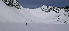
Pension Sindlovec in Zuberec is nice wooden cottage with restaurant and information center. Starting point for ski tours to the Salatín and Spálená valleys, to the peaks of Salatín, Brestová, Spálená or Pachola.
Tours starting from hut
Ski tours around Hut Zuberec - Penzion Šindlovec
-

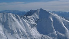
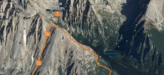
Pachoľa 2167 m
Zuberec - Penzion Šindlovec Západné Tatry Slovakia
- Length of ascent7 km
- ascent1130 m
- duration5,5-7 h
- Fitness difficulty ♦♦◊◊
- Technical difficulty ♦♦♦◊
Výstup na Pachoľu vede od penziónu Šindlovec východnou Muldou Spálené doliny. Klíčovým místem túry je výstup do Baníkovského sedla. Ze sedla po hřebeni na vrchol. Sjezd po trase výstupu.

-
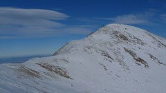
Salatín 2048 m
Zuberec - Penzion Šindlovec Západné Tatry Slovakia
- Length of ascent2 km
- ascent530 m
- duration2,5-3,5 h
- Fitness difficulty ♦♦◊◊
- Technical difficulty ♦♦◊◊
Nejoblíbenější v oblasti Zuberce - Spálené doliny. Nejčastěji se chodí od horní stanice lanovky "Spálená" přes Centrálny žlab do Salatinskeho sedla a odtud na vrchol. Kromě trasy výstupu je několik dalších variant sjezdu.
-

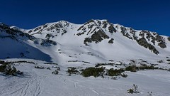
Spálená 2083 m
Zuberec - Penzion Šindlovec Západné Tatry Slovakia
- Length of ascent6 km
- ascent1050 m
- duration5-6,5 h
- Fitness difficulty ♦♦◊◊
- Technical difficulty ♦♦♦◊
The ascent to the "Spálená" peak leads from the Šindlovec guest house through the eastern part of the "Spálená dolina" valley. The ascent to the summit leads through a wide depression "Spálená mulda". The downhill copied the ascent route and is excellent.
-
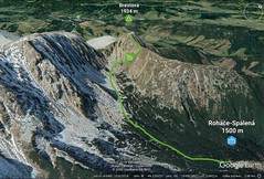
Brestová 1934 m
Zuberec - Penzion Šindlovec Západné Tatry Slovakia
- Length of ascent2,5 km
- ascent430 m
- duration2-3 h
- Fitness difficulty ♦◊◊◊
- Technical difficulty ♦◊◊◊
450 vertical meters at the beginning can be saved with the cable car. Then through the valley Spálena dolina under the Přední Salatín and then right into the saddle and easy upwards. The descent follows ascent route.
- Country
- Slovakia
- Montains
- Západné Tatry
- Open (winter)
- daily
- Beds
- 24
- Winterraum
- no
- Shortening of access (cableway, lift, taxi, snowcat...)
- no, access by car
- Card Pay
- no
- Shower
- yes
- Wifi
- yes
- UTM / CH1903 x ("longitude" E/W)
- 49°14.57280'
- UTM / CH1903 y ("latitude" N/S)
- 19°42.83628'
- Map
- The West Tatras, 1:25000, Tatraplan, Nr. 2501 Západné Tatry - Roháče, 1:50000, Nr. 112, VKÚ Harmanec
- Guides
- Výber lyžiarskych a skialpinistických túr / slovensky
- Phone (hut)
- 00421/903/509670
- Phone (valley)
- -
- Cell phone
- -
- Mobile Signal
- yes
- Web
- sindlovec.sk
- sindlovec@sindlovec.sk
- Owner of hut
- privat
- Šindľovec
- Reservation
- phone, e-mail
- Start Point
- Roháče - Spálená lanovka / horná stanica
- UTM / CH1903 x ("longitude" E/W)
- 49°13.34844'
- UTM / CH1903 y ("latitude" N/S)
- 19°42.07278'
- Altitude
- 1500 m
- Ascent (height difference)
- 455 m
- Time of Access
- 1-1,5 h
- Shortening lift
- yes, cablecarfro Spálená valley
- Avalanche danger
- Stredisko lavinovej prevencie HZS
- Weather
- Zverovka / Metoblue.com Zuberec / yr.no HZS - počasí v horách HZS / Mountain Rescue login"user" - meteo station "Pod Klinom" Baníkov 2178m / mountain-forecast.com Ostrý Roháč 2087 m / mountain-forecast.com Volovec / mountain-forecast.com Slovensko / shmu.sk Slovensko Slovensko - meteograms / shmu.sk Salatínsky Vrch / Metoblue.com
- Snow report
- Slovensko / meteo.sk Roháče Spálená / onthesnow.com (en) Roháče Spálená / bergfex (de)
- Webcams
- Zverovka Spálená 1250m Žiarska chata
- Region
- Liptov - turismus zuberec.sk
- Public traffic
- Timetables / Cestovné poriadky
- Skiresort nearby
- Roháče Spálená - Zverovka
- Other links
- Ubytovámí Západné Tatry
hut Zuberec - Penzion Šindlovec - Reviews
There are no reviews in this section yet. Click the Add Review button to add first review.
Best ski tours in mountains Západné Tatry, Slovakia
-
Baranec 2184 m
Žiarska chata Západné Tatry Slovakia
- Length of ascent2,7 km
- ascent900 m
- duration4-5,5 h
- Fitness difficulty ♦♦♦◊
- Technical difficulty ♦♦♦♦
Baranec is the highest ski tour above the mountain hut Žiarska chata. The most popular variant is Jarný žlab. First, near the hut overcomes the creek. Then follow the ascent through the Jarný žlab, on the steep slope to the ridge. It goes up easier. It is recommended descent trough the Jarny žlab or the neighboring Maďarský žlab. The descent through the Baranecký kotol is very difficult and dangerous.
-

Smutné sedlo 1963 m
Žiarska chata Západné Tatry Slovakia
- Length of ascent3 km
- ascent670 m
- duration2,5-4 h
- Fitness difficulty ♦♦◊◊
- Technical difficulty ♦♦◊◊
The saddle ski tour to Smutné sedlo is a popular ski hike. It starts from Žiarska chata in the direction to Žiarske Sedlo. A sharp left turn into and further through dwarf pine and on the so-called terrace under the slope to the saddle, 1963 m. Ascend follows ascent.
-
Hrubá kopa via Lúčne sedlo 2166 m
Žiarska chata Západné Tatry Slovakia
- Length of ascent3,8 km
- ascent840 m
- duration3,5-5 h
- Fitness difficulty ♦♦◊◊
- Technical difficulty ♦♦◊◊
Hrubá kopa via saddle Hrubá priehyba is one of the most difficult ski tours in Žiarska dolina. The ascent to the saddle Hrubá priehyba between Hrubá kopa and Tri kopy is very steep in the second half, at the end around 35 ° - watch for avalanche danger. If it is not possible to reach the summit, put the skis under the saddle. To peak with ice axe and crampons. Great departure on a steep, broad southern slope.
Best ski tours in Slovakia by skitour.guru
-
Furkotský štít 2404 m
Chata pod Soliskom - Štrbské Pleso Vysoké Tatry Slovakia
- Length of ascent3,5 km
- ascent650 m
- duration2,5-4 h
- Fitness difficulty ♦♦◊◊
- Technical difficulty ♦♦◊◊
Furkotský štít je oblíbený tatranský vrchol. Nejlépe je dostupný z Chaty pod Soliskom. Výstup vede Furkotskou dolinou přes Nižné a Vyšné Wahlenbergovo pleso. Za jezerem je možné vystupovat dvěma liniemi. Za dobrých podmínek širokým svahem (vlevo) na hřeben a po něm v mačkách na vrchol. Variantou výstupu je trasa přes Bystré sedlo. Tudy obvykle vede i trasa sjezdu. Návrat k chatě vyžaduje na krátký úsek nalepit pásy.
-
Patria 2203 m
Chata pod Soliskom - Štrbské Pleso Vysoké Tatry Slovakia
- Length of ascent5 km
- ascent840 m
- duration3-4,5 h
- Fitness difficulty ♦♦◊◊
- Technical difficulty ♦♦◊◊
Lyžařská túra ze Štrbského plesa na vrchol Patria nabízí možnost okružní trasy, sjezd vede Mlynickou dolinou.
-
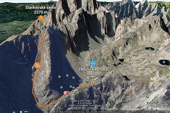
Slavkovské sedlo 2269 m
Zbojnícka chata Vysoké Tatry Slovakia
- Length of ascent1,8 km
- ascent420 m
- duration3-4 h
- Fitness difficulty ♦♦◊◊
- Technical difficulty ♦♦◊◊
The ski tour to the wide saddle Slavkovské sedlo offers a high-quality descent on a slope with a constant incline with an average inclination of 35 degrees. Attention, due to the grassy ground, it is a slope with avalanche potential.