
 Česky
Česky Deutsch


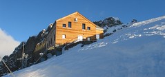
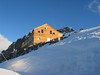
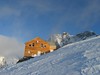

The Rifugio Marco e Rosa is the highest mountain hut in the Italian province of Lombardy. An ideal place for climbs to the peaks of Piz Bernina, Piz Zupo and Piz Argient. Open sporadically in winter, usually only on weekends. Spacious, but cold and unfurnished winter room.
Ski tours around Hut Rifugio Marco e Rosa
- Country
- Italy
- Montains
- Bernina Alps
- Open (winter)
- unknown
- Beds
- 48
- Winterraum
- open, 34 beds
- Shortening of access (cableway, lift, taxi, snowcat...)
- no
- Luggage transport
- no
- Shower
- yes
- Wifi
- yes
- UTM / CH1903 x ("longitude" E/W)
- 790163
- UTM / CH1903 y ("latitude" N/S)
- 138782
- Map
- 1277 Piz Bernina, Swisstopo 1:25000 S268 Julierpass, Swisstopo 1:50000
- Guides
- Graubünden Süd / SAC-CAS.ch, deutsch Die klassischen Skitouren (SAC, deutsch) Les classiques de randonnée à ski / SAC-CAS.ch, francais Engadin / Rother Skitourenführer, deutsch Scialpinismo tra Lombardia e Grignoni / Versante Sud, italiano
- Phone (hut)
- +39 0342 515370
- Phone (valley)
- +39 0342 454053
- Cell phone
- +39 347 2563096
- Mobile Signal
- yes
- Web
- rifugi.lombardia.it
- biancoextrem@libero.it
- Owner of hut
- CAI Sondrio
- Reservation
- e-mail, phone
- Start Point
- Morteratsch Bahnhof
- UTM / CH1903 x ("longitude" E/W)
- 792200
- UTM / CH1903 y ("latitude" N/S)
- 147447
- Altitude
- 1896 m
- Ascent (height difference)
- 1720 m
- Time of Access
- 8-10 h
- Shortening lift
- no
- Start Point
- Berghaus Diavolezza
- UTM / CH1903 x ("longitude" E/W)
- 794223
- UTM / CH1903 y ("latitude" N/S)
- 143181
- Altitude
- 2978 m
- Ascent (height difference)
- 950 m
- Time of Access
- 7-9 h
- Shortening lift
- yes, by cable car from Diavolezza-Lagalb train station to Berghaus Diavolezza
- Avalanche danger
- slf.ch - Institut für Schnee- und Lawinenforschung
- Weather
- Diavolezza / meteoblue.com Bovalhütte / srf.ch Diavolezza / snow-forecast.com Piz Bernina-La Spedla / mountain-forecast.com Piz Palü 3889m/ mountain-forecast.com St. Moritz / wetter.com Switzerland - animation / srf.ch Alpenvereinswetter
- Snow report
- Diavolezza - Lagalb / snow-forecast.com St. Moritz / onthesnow.com Diavolezza - Lagalb / bergfex.ch St. Moritz / snow.myswitzerland.com
- Webcams
- All webcams around St. Moritz Diavolezza
- Region
- Graubünden Engadin St. Moritz Pontresina
- Public traffic
- SBB Railway Postauto.ch - bus
- Skiresort nearby
- St. Moritz - Corviglia - Corvatsch - Diavolezza
- Other links
- Switzerland Tourism Regione Lombardia
hut Rifugio Marco e Rosa - Reviews
There are no reviews in this section yet. Click the Add Review button to add first review.
Best ski tours in mountains Bernina Alps, Italy
-

Monte Rosso 3088 m
Fornohütte - Capanna del Forno Bernina Alps Switzerland
- Length of ascent4 km
- ascent840 m
- duration4-5,5 h
- Fitness difficulty ♦♦◊◊
- Technical difficulty ♦♦♦◊
Skvělým skialpovým vrcholem uprostřed oblasti je Monte Rosso. Výhodou okruhu je maximalistický krajinářský zážitek. Po výstupu do dvou sedel se otevřou vždy nové výhledy. Od chaty míříme nejprve do sedla Sella del Forno. Koukáme na Berninu a dolů na skiresort Valmalenco. Krásným kotlem po krátkém sjezdu traverujeme a míříme nahoru do druhého sedla – Passo di Val Bona. Po strmějším svahu do místa na skalním hřebenu, kde je skidepot. Odtud v mačkách na vrchol. Na lyžích parádní sjezd jihozápadním svahem na ledovec Forno a zpět nahoru k chatě.

-
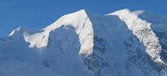
Piz Palü 3882 m
Diavolezza Berghaus Bernina Alps Switzerland
- Length of ascent6,5 km
- ascent1180 m
- duration6,5-8,5 h
- Fitness difficulty ♦♦♦◊
- Technical difficulty ♦♦♦◊
The Piz Palü with its characteristic three pillars is probably the most popular "not 4000" in the Alps. The exit from the Berghaus Diavolezza is ideal, it is also possible from the Bovalhütte. The key point for the ascent and descent is the passage of the Labyrinth between the Seraks. Continue over a relatively steep glacier to the ski depot. Then ascent with ice axe and crampons along the exposed summit ridge. The usual goal of ski mountaineers is the eastern summit - 3882 m.
-

Pizzi dei Rossi 3026 m
Fornohütte - Capanna del Forno Bernina Alps Switzerland
- Length of ascent3 km
- ascent665 m
- duration4,5-6 h
- Fitness difficulty ♦♦◊◊
- Technical difficulty ♦♦♦♦
Skialpová Pizzi dei Rossi je ideální volbou pro poslední den na chatě. Návrat na parkoviště pod Malojapassem má úplně jinou úroveň, než přesun údolím. Výstup z chaty vede často traverzy zápaního svahu, na jaře jsou haršajsny nutností. Náročný je až výstup prudkým svahem do sedla, většinou bude nutné nasadit mačky a lyže dát batoh. Ze sedla nalehko a bez lyží na vrchol. Sjezd severním kuloárem je zprvu velmi prudký a bmusí se projet zúžením mezi skalami. Dál po pláních je už luxusní svah a když je dobrý sníh, je to fantastický sjezd. Ten pokračuje i údolím Val Muretto až na planinu Canis. Pár krátkých protisvahů na kraj soutěsky a pak už zase jen dolů k mostu přes horskou bystřinu a po rovině na parkoviště.
Best ski tours in Italy by skitour.guru
-

Kleine Gaisl - Croda Rossa Piccada 2859 m
Pragser Dolomiten - Dolomiti di Braies Dolomiti Italy
- Length of ascent10,5 km
- ascent1690 m
- duration6-8 h
- Fitness difficulty ♦♦♦♦
- Technical difficulty ♦♦♦◊
Skialpinistická túra na Kleine Gaisl (italsky Croda Rossa Piccada) patří k těm náročnějším. Jak kvůli délce, tak i lavinovému nebezpečí za severních svazích. Členitým terénem přes sedlo Fossesser Ridl. Nejobtížnější je vystoupat na hřeben pod Roten Wand a pak po plochém hřebenu na vrchol. Odměnou je impozantní výhled na celé východní Dolomity i mohutné skály Hohe Gaisl. Z vrcholu je vidět sjezdová linie z Passo Colfiedo. Sjezd kopíruje výstupovou trasu.
-

Seekofel - Croda del Becco 2810 m
Pragser Dolomiten - Dolomiti di Braies Dolomiti Italy
- Length of ascent8 km
- ascent1370 m
- duration5-6,5 h
- Fitness difficulty ♦♦♦◊
- Technical difficulty ♦♦◊◊
Skialpová túra na Seekofel (italsky Croda del Becco) od jezera Pragser Wildsee (Lago di Braies( slibuje velký vyhlídkový zážitek, jak už to bývá u túr v Dolomitech. Nádherné skály lemující jezero a následně výstup údolíčkem a členitým terénem na náhorní plošinu. Následuje odbočka vravo, západním směrem a nad chatou Seekofelhütte do sedla Ofenscharte / Forcella della Forno. Odtud po hřebenu (často vyfoukaný) na vrchol. Letecký pohled na jezero Pragser Wildsee i protější vrchol Kleine Gaisl. V dáli je vidět Tofana i TreCime di Lavaredo. Sjezd po trase výstupu s možností varianty západně od výstupové linie.
-

Monte Cristallo - Passo Cristallo 2806 m
Dolomiti d´Ampezzo - Cortina, Cimabanche, Schluderbach Dolomiti Italy
- Length of ascent6,5 km
- ascent1390 m
- duration4-5,5 h
- Fitness difficulty ♦♦♦◊
- Technical difficulty ♦♦♦♦
An challenging tour to the Passo/Forcelle Cristallo is a dream come true for everyone who loves thrilling descents. It begins just above the Schluderbach junction, and the most extensive variant finishes with a descent to Passo Tre Croci. Ascent starts along a shaded, gentle, rocky streambed leading into a grand alpine valley. You exit its narrow confines via a tight corridor through the rocks (on the left, to the north). Afterward, you cross a consistently steep, wide slope heading toward a choke point below the saddle.
Descent: Usually, you follow the same path used for the ascent. A very worthwhile alternative is descending on the south side. First, there’s a very steep section, which often has firn-like snow thanks to the sun. While skiing down the scree slopes, stay to the right, then go between the dwarf pines down to the saddle near Hotel Tre Croci (bus stop).