
 Česky
Česky Deutsch


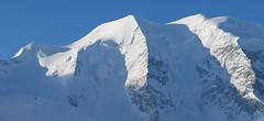


The Piz Palü with its characteristic three pillars is probably the most popular "not 4000" in the Alps. The exit from the Berghaus Diavolezza is ideal, it is also possible from the Bovalhütte. The key point for the ascent and descent is the passage of the Labyrinth between the Seraks. Continue over a relatively steep glacier to the ski depot. Then ascent with ice axe and crampons along the exposed summit ridge. The usual goal of ski mountaineers is the eastern summit - 3882 m.
Peak
- Country
- Switzerland
- Montains
- Bernina Alps
- Tags
- Bernina Engadin Graubünden Pontresina Schweiz St. Moritz Switzerland
- Hut
- Diavolezza Berghaus
- UTM / CH1903 x ("longitude" E/W)
- 794318
- UTM / CH1903 y ("latitude" N/S)
- 139541
Start point
- Start Point
- Diavolezza Berghaus
- Altitude
- 2978 m
- UTM / CH1903 x ("longitude" E/W)
- 794223
- UTM / CH1903 y ("latitude" N/S)
- 143181
- village, valley
- Val Bernina
- cableway / lift
- no
Conditions
- Avalanche danger
- slf.ch - Institut für Schnee- und Lawinenforschung
- Weather
- Diavolezza / meteoblue.com Diavolezza / srf.ch Diavolezza / snow-forecast.com Munt Pers 3207m / mountain-forecast.com Piz Bernina-La Spedla / mountain-forecast.com Piz Lagalb 2959 / mountain-forecast.com Piz Palü 3889m/ mountain-forecast.com Piz Palü 3889m / meteoblue.com Piz Argient 3945m/ mountain-forecast.com Diavolezza / kachelmannwetter.com St. Moritz / wetter.com Switzerland - animation / srf.ch Alpenvereinswetter
- Snow report
- Diavolezza - Lagalb / snow-forecast.com St. Moritz / onthesnow.com Diavolezza - Lagalb / bergfex.ch St. Moritz / snow.myswitzerland.com
- Webcams
- All webcams around St. Moritz Diavolezza
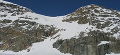
Ski tour map on Piz Palü


 bivakovací nouzová chata
  cepín a mačky potřeba
 exponovaný, obtížný terén
 horská chata
 hôtel, penzion
 lanovka, vlek
 lavinové nebezpečí, svah > 30°
 ledovcové trhliny
 lehká túra
 mimořádně obtížná túra
 mírně obtížná túra
 obtížná túra
 parkoviště
 přístup k chatě
 restaurace
 sedlo
sedlo sjezd
sjezd skidepo
 vrchol
 výstup
 začátek ledovce
- bivouac, winter room
- crampons & ice axe necessary
- exposed, difficulty terrain
- mountain hut, refuge
- hotel, pension
- cableway, skilift
- avalanche danger, slope > 30°
- glacier cracks
- little difficult tour
- extremely difficult tour
- rather difficult tour
- difficult tour
- parking
- hut acces
- restaurant
- col, pass, saddle
- descent
- skidepot
- peak, summit
- ascent
- glacier beginning
- biwak, winterraum
- steigeisen & pickel erforderlich
- ausgesetzt, schwierige gelände
- berghütte
- hotel, pension
- seilbahn, skilift
- lawinengefahr, hangneigung > 30°
- gletscherspalten
- wenig schwierige tour
- äusserst schwierige tour
- ziemlich schwierige tour
- schwierige tour
- parkplatz
- zugang zur hütte
- restaurant
- sattel, joch, pass
- abfahrt
- skidepot
- gipfel
- aufsieg
- gletscher anfang
- bivacco, locale invernale
- ramponi & piccozza necessari
- esposto, terreno difficolt?
- rifugio, capanna
- alberghi, pensione
- funivia, seggiovia
- pericolo di valanghe, pendenza > 30°
- crepe glacier
- tour piccolo difficile
- tour estremamente difficile
- tour piuttosto difficile
- escursioni difficili
- parcheggio
- accesso capanna
- ristorante
- col, sella, passo, forcella
- discesa
- sci deposito
- picco, vertice, piz
- salita
- inizio ghiacciaio
- bivouac, local d'hiver
- crampons & piolet nécessaire
- exposée, difficulté du terrain
- cabane de montagne, refuge
- hôtel, pension
- téléphérique, téléski
- danger d'avalanche, pente > 30°
- crevasse du glacier
- peu difficile tour
- extr?mement difficile tournée
- assez difficile tour
- difficile tournée
- parking
- acces cabane
- restaurant
- col, selle
- descente
- skis dépôt
- pic, sommet
- ascension
- début glacier
- < 20°
- 20° - 25°
- 25° - 30°
- 30° - 35°
- 35° - 40°
- > 40°
Current weather conditions in the tour area
Planning of ski tour
- Fitness difficulty
-
- ♦♦♦◊
- Technical difficulty
-
- ♦♦♦◊
- best time for this tour
- mid March-May
- Glacier
- Yes
- Map
- 1277 Piz Bernina, Swisstopo 1:25000 S268 Julierpass, Swisstopo 1:50000
- Guides
- Graubünden Süd / SAC-CAS.ch, deutsch Die klassischen Skitouren / SAC-CAS.ch, deutsch Les classiques de randonnée à ski / SAC-CAS.ch, francais Engadin / Rother Skitourenführer, deutsch
About Ski tour
- Time difficulty
- Ascent (height difference)
- 1180 m
- Lenght of ascent
- 6,5 km
- Descent (height difference)
- 1180 m
- Total Lenght of tour
- 13 km
- Total time of the tour
- 6,5-8,5 h
- Elevation Range
- 2750 - 3882 m
- Principal Aspect
- NW, N, SE S-south, N-north, W-west, E-east
Download
- GPX (track only)
- Piz-Palu_Diavolezza_TRK.gpx best for display on a detailed topographical map (mapy.cz) or in apps for smartphones (Locus, Garmin Connect, etc.)
- GPX (waipoints, track)
- Piz-Palu_Diavolezza_skitour.gpx great for uploading in GPS device
- KML (with POI)
- Piz-Palu_3882_Diavolezza_skitour.kml for viewing in the Google Earth 3D map application, which you can install on your PC
Current avalanche potential on tour - Piz Palü

tour Piz Palü - Reviews
There are no reviews in this section yet. Click the Add Review button to add first review.
Ski tours around Hut Diavolezza Berghaus, in mountains Bernina Alps, Switzerland
-

Val Arlas - freetour 2978 m
Diavolezza Berghaus Bernina Alps Switzerland
- Length of ascent0,2 km
- ascent30 m
- duration0,75-1,5 h
- Fitness difficulty ♦◊◊◊
- Technical difficulty ♦♦◊◊
The freeride descent through the Val Arlas valley is easy to reach from the top station of the Diavolezza cable car. After a short arrival on the slopes, skate to the upper point of the ski lift and then left to the east slope, which leads the skiers into the north-facing valley. During the descent, the incline gradually decreases and at the end you drive around the Rhaetian Railway to the lower station of the Diavolezza cable car.

-
Piz Cambrena 3601 m
Diavolezza Berghaus Bernina Alps Switzerland
- Length of ascent6 km
- ascent1410 m
- duration6,5-8 h
- Fitness difficulty ♦♦♦◊
- Technical difficulty ♦♦♦◊
Piz Cambrena is a bit of a minor interest. In contrast to the more famous mountains - Palü, Bernina, Zupo etc. - the ascent starts from the road to Passo Bernina or from Ospizio Bernina (hotel, train stop). Pay attention to the eastern orientation of the slope on warmer spring days - from morning strong sunshine on the main slope of the ascent and descent.
-
Morteratsch Glacier freetour 2978 m
Diavolezza Berghaus Bernina Alps Switzerland
- Length of ascent0 km
- ascent0 m
- duration0,75-1,5 h
- Fitness difficulty ♦◊◊◊
- Technical difficulty ♦♦◊◊
The Morteratsch Freeride is a popular activity for skiers in the St. Moritz region. From the Berghaus Diavolezza you first drive down to the moraine of the Vadret Pers, which flows down from the Piz Palü. We continue around the seraks to the Morteratsch Glacier to the Morteratsch train station, where there is also a restaurant with a garden. This descent is mostly a promising ski tour. If you want to enjoy perfect skiing, you have to cross the Pers glacier and climb the 500 vertical meters to Isla Pers. First-class powder is often waiting on the northern slope. I remind you that the best view of the surrounding mountains is possible from the whirlpool on the terrace of the Berghotel Diavolezza.
-

Piz Zupo - Piz Argient 3990 m
Diavolezza Berghaus Bernina Alps Switzerland
- Length of ascent7,5 km
- ascent1695 m
- duration8-10,5 h
- Fitness difficulty ♦♦♦◊
- Technical difficulty ♦♦♦◊
Piz Zupo and Piz Agnel lie between neighboring massifs of Palü and Bernina. The greatest danger of this ski tour are the numerous crevasses that are often hidden under the snow. The skimo tour can be started in the nearby Rifugio Marco e Rosa or from distant Berghaus Diavolezza and Chamanna Boval.
Best ski tours in Bernina Alps by skitour.guru
-

Piz Bernina 4048 m
Chamanna Boval / Bovalhütte Bernina Alps Switzerland
- Length of ascent7,5 km
- ascent1695 m
- duration8-10,5 h
- Fitness difficulty ♦♦♦♦
- Technical difficulty ♦♦♦♦
Piz Bernina is the only 4000m peak in the Eastern Alps. The greatest danger are the huge and numerous crevasses on the Morteratsch Glacier and the ridge to the summit. Piz Bernina sets off from Chamanna Boval or Rifugio Marco e Rosa on the plateau below the summit. Bernina is a demanding alpine challenge.
-

Cima di Rosso 3365 m
Fornohütte - Capanna del Forno Bernina Alps Switzerland
- Length of ascent7,5 km
- ascent1255 m
- duration4,5-6 h
- Fitness difficulty ♦♦♦◊
- Technical difficulty ♦♦♦◊
Cima di Rosso je skialpová klasika v oblasti Forno. Ledovcová túra s vynikajícim výhledem na Munt Disgrazia a Piz Bernina. Kromě sjezdu po trase výstupu je možná sjezdová alernativa severním svahem, kde bývá často prašan.
-

Pizzi dei Rossi 3026 m
Fornohütte - Capanna del Forno Bernina Alps Switzerland
- Length of ascent3 km
- ascent665 m
- duration4,5-6 h
- Fitness difficulty ♦♦◊◊
- Technical difficulty ♦♦♦♦
Skialpová Pizzi dei Rossi je ideální volbou pro poslední den na chatě. Návrat na parkoviště pod Malojapassem má úplně jinou úroveň, než přesun údolím. Výstup z chaty vede často traverzy zápaního svahu, na jaře jsou haršajsny nutností. Náročný je až výstup prudkým svahem do sedla, většinou bude nutné nasadit mačky a lyže dát batoh. Ze sedla nalehko a bez lyží na vrchol. Sjezd severním kuloárem je zprvu velmi prudký a bmusí se projet zúžením mezi skalami. Dál po pláních je už luxusní svah a když je dobrý sníh, je to fantastický sjezd. Ten pokračuje i údolím Val Muretto až na planinu Canis. Pár krátkých protisvahů na kraj soutěsky a pak už zase jen dolů k mostu přes horskou bystřinu a po rovině na parkoviště.