
 Česky
Česky Deutsch


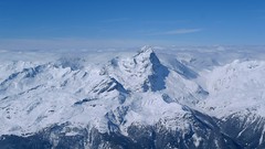
Mulegns is a village on the road from Chur to the Julier Pass. Mulegns is primarily the starting point for a spectacular ski tour to Piz Platta. In the village you can stay at the Posthotel Löwen. A building in the style of classicism with the charm of antiquity, when horse-drawn carriages rode on this street instead of cars.
Tours starting from hut
Ski tours around Hut Mulegns - Posthotel Löwen
- Country
- Switzerland
- Montains
- Platta Group / Oberhalbstein
- Open (winter)
- Beds
- 20
- Winterraum
- Shortening of access (cableway, lift, taxi, snowcat...)
- accessible by car
- UTM / CH1903 x ("longitude" E/W)
- 767416
- UTM / CH1903 y ("latitude" N/S)
- 154811
- Map
- Julierpass 268 S, Swisstopo 1:50000 Bivio, Landeskarte Schweiz Nr. 1256, 1:25000
- Guides
- Les classiques de randonée s ski / SAC-CAS.ch, french Die klassischen Skitouren / SAC-CAS.ch, deutsch Graubünden Süd Skitouren / SAC-CAS.ch, deutsch Surselva / Rother, deutsch Skitouren-Wochenenden / Rother, deutsch
- find current conditions and experiences on the spot
- gipfelbuch.ch
- Phone (hut)
- +41 81 637 16 81
- Phone (valley)
- -
- Cell phone
- -
- Web
- Posthotel Löwen
- -
- Owner of hut
- -
- Avalanche danger
- slf.ch - Institut für Schnee- und Lawinenforschung
- Weather
- Piz Platta, mountain-forecast.com Piz Platta, meteoblue.com Savognin, snow-forecast.com Bivio, snow-forecast.com Mulegns / meteoblue.com Switzerland / meteo.ch SRF meteo - animation Alpenvereinswetter
- Snow report
- Savognin, snow-forecast.com Bivio, snow-forecast.com Savognin, bergfex.ch Bivio, bergfex.ch Avers, bergfex.ch Savognin, onthesnow.com Bivio, onthesnow.com Avers, onthesnow.com
- Webcams
- Savognin Somgant 2100 m Bivio skiresort Bivio Avers, Juf
- Region
- Surselva Graubünden
- Public traffic
- SBB Railway Postauto.ch - bus
- Skiresort nearby
- Savognin Bivio Avers
- Other links
- Switzerland Tourism
hut Mulegns - Posthotel Löwen - Reviews
There are no reviews in this section yet. Click the Add Review button to add first review.
Best ski tours in Switzerland by skitour.guru
-
Pizzo Lucendro 2963 m
Rotondohütte Urner Alps Switzerland
- Length of ascent5,5 km
- ascent1090 m
- duration4-6 h
- Fitness difficulty ♦♦◊◊
- Technical difficulty ♦♦♦◊
Pizzo Lucendro je výrazný vrchol nad Gotthardpassem a také prvotřídní rozhledna. Na túru lze vyrazit z údolního Realpu, snazší je start z chaty Rotondohütte. Po sjezdu nad úroveň salaší nastává dlouhý výstup členitým terénem, který nabírá na strmosti. Těsně pod skalním sedlem je v úzkém koridoru zvládání otočky nutností. Za sedlem následuje poměrně snadný výstup do sedla, k místu, kde bývá depo lyží. Při výstupu po hřebeni k vrcholovému kříži pozor na převěje a místy exponovaný terén. Při sjezdu za jarního firnu se vyplatí počkat v sedle, než slunce změkčí stinný svah pro velkolepý odpolední sjezd západním svahem. Z nejnižšího bodu návrat na chatu nebo sjezd až do Realpu.

-

Piz Bernina 4048 m
Chamanna Boval / Bovalhütte Bernina Alps Switzerland
- Length of ascent7,5 km
- ascent1695 m
- duration8-10,5 h
- Fitness difficulty ♦♦♦♦
- Technical difficulty ♦♦♦♦
Piz Bernina is the only 4000m peak in the Eastern Alps. The greatest danger are the huge and numerous crevasses on the Morteratsch Glacier and the ridge to the summit. Piz Bernina sets off from Chamanna Boval or Rifugio Marco e Rosa on the plateau below the summit. Bernina is a demanding alpine challenge.
-

Blanc de Moming - Dôme Circuit 3649 m
Cabane du Mountet Walliser Alpen / Alpes valaisannes Switzerland
- Length of ascent10 km
- ascent2035 m
- duration9-11 h
- Fitness difficulty ♦♦♦♦
- Technical difficulty ♦♦♦♦
Blanc de Moming - Dôme is a beautiful but also very demanding complex ski tour. First ascent from Cabane Mountet to La Forcle saddle and then not very easy descent and then ascent along the Glacier du Besso. At the end of the glacier there is an uncomfortable border between snow and rock. Climb a rocky slope. First along a flat ridge, which is increasingly exposed. It is recommended to belay in windy weather. At the beginning of the spectacular descent along the Glacier de Moming, pay attention to the gigantic cracks. The departure line (keep left) turns from the northern to the western slope. After reaching the valley there is an easy ascent along the Glacier de Zinal back to Cabane Mountet.