
 Česky
Česky Deutsch


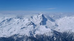


Impressive very long ski tour on the more pronounced Piz Platta summit in the Plattagruppe-Oberhalbstein mountain group. Aproach from the village of Mulengs - road from Tiefencastel to Julierpass. First a few kilometers through the forest, then left at the foot of the mountain and then constantly up the northeast slope to the plateau (ski depot). Next you have to climb the southern slope to the top plateau with crampons and ice axe.
Peak
- Country
- Switzerland
- Montains
- Platta Group / Oberhalbstein
- Tags
- Graubünden Oberhalbstein Plattagruppe Schweiz Switzerland
- Hut
- Mulegns - Posthotel Löwen
- UTM / CH1903 x ("longitude" E/W)
- 762999
- UTM / CH1903 y ("latitude" N/S)
- 150616
Start point
- Start Point
- Mulegns - Posthotel Löwen
- Altitude
- 1481 m
- UTM / CH1903 x ("longitude" E/W)
- 767416
- UTM / CH1903 y ("latitude" N/S)
- 154811
Conditions
- Avalanche danger
- slf.ch - Institut für Schnee- und Lawinenforschung
- Weather
- Piz Platta, mountain-forecast.com Piz Platta, meteoblue.com Savognin, snow-forecast.com Bivio, snow-forecast.com Mulegns / meteoblue.com Switzerland / meteo.ch SRF meteo - animation Alpenvereinswetter
- Snow report
- Savognin, snow-forecast.com Bivio, snow-forecast.com Savognin, bergfex.ch Bivio, bergfex.ch Avers, bergfex.ch Savognin, onthesnow.com Bivio, onthesnow.com Avers, onthesnow.com
- Webcams
- Savognin Somgant 2100 m Bivio skiresort Bivio Avers, Juf
Ski tour map on Piz Platta


 bivakovací nouzová chata
  cepín a mačky potřeba
 exponovaný, obtížný terén
 horská chata
 hôtel, penzion
 lanovka, vlek
 lavinové nebezpečí, svah > 30°
 ledovcové trhliny
 lehká túra
 mimořádně obtížná túra
 mírně obtížná túra
 obtížná túra
 parkoviště
 přístup k chatě
 restaurace
 sedlo
sedlo sjezd
sjezd skidepo
 vrchol
 výstup
 začátek ledovce
- bivouac, winter room
- crampons & ice axe necessary
- exposed, difficulty terrain
- mountain hut, refuge
- hotel, pension
- cableway, skilift
- avalanche danger, slope > 30°
- glacier cracks
- little difficult tour
- extremely difficult tour
- rather difficult tour
- difficult tour
- parking
- hut acces
- restaurant
- col, pass, saddle
- descent
- skidepot
- peak, summit
- ascent
- glacier beginning
- biwak, winterraum
- steigeisen & pickel erforderlich
- ausgesetzt, schwierige gelände
- berghütte
- hotel, pension
- seilbahn, skilift
- lawinengefahr, hangneigung > 30°
- gletscherspalten
- wenig schwierige tour
- äusserst schwierige tour
- ziemlich schwierige tour
- schwierige tour
- parkplatz
- zugang zur hütte
- restaurant
- sattel, joch, pass
- abfahrt
- skidepot
- gipfel
- aufsieg
- gletscher anfang
- bivacco, locale invernale
- ramponi & piccozza necessari
- esposto, terreno difficolt?
- rifugio, capanna
- alberghi, pensione
- funivia, seggiovia
- pericolo di valanghe, pendenza > 30°
- crepe glacier
- tour piccolo difficile
- tour estremamente difficile
- tour piuttosto difficile
- escursioni difficili
- parcheggio
- accesso capanna
- ristorante
- col, sella, passo, forcella
- discesa
- sci deposito
- picco, vertice, piz
- salita
- inizio ghiacciaio
- bivouac, local d'hiver
- crampons & piolet nécessaire
- exposée, difficulté du terrain
- cabane de montagne, refuge
- hôtel, pension
- téléphérique, téléski
- danger d'avalanche, pente > 30°
- crevasse du glacier
- peu difficile tour
- extr?mement difficile tournée
- assez difficile tour
- difficile tournée
- parking
- acces cabane
- restaurant
- col, selle
- descente
- skis dépôt
- pic, sommet
- ascension
- début glacier
- < 20°
- 20° - 25°
- 25° - 30°
- 30° - 35°
- 35° - 40°
- > 40°
Current weather conditions in the tour area
Planning of ski tour
- Fitness difficulty
-
- ♦♦♦♦
- Technical difficulty
-
- ♦♦♦◊
- best time for this tour
- March-mid May
- Glacier
- Yes
- Map
- Julierpass 268 S, Swisstopo 1:50000 Bivio, Landeskarte Schweiz Nr. 1256, 1:25000
- Guides
- Les classiques de randonée s ski / SAC-CAS.ch, french Die klassischen Skitouren / SAC-CAS.ch, deutsch Graubünden Süd Skitouren / SAC-CAS.ch, deutsch Surselva / Rother, deutsch Skitouren-Wochenenden / Rother, deutsch
About Ski tour
- Time difficulty
- Ascent (height difference)
- 1980 m
- Lenght of ascent
- 11 km
- Descent (height difference)
- 1980 m
- Total Lenght of tour
- 22 km
- Total time of the tour
- 8-11 h
- Elevation Range
- 1481 - 3392 m
- Principal Aspect
- NE, S S-south, N-north, W-west, E-east
Download
- GPX (track only)
- Piz-Platta_TRK.gpx best for display on a detailed topographical map (mapy.cz) or in apps for smartphones (Locus, Garmin Connect, etc.)
- GPX (waipoints, track)
- Piz-Platta_Mulegns_skitour.gpx great for uploading in GPS device
- KML (with POI)
- Piz-Platta_3392_Mulegns_skitour.kml for viewing in the Google Earth 3D map application, which you can install on your PC
Video of tour on Piz Platta
Current avalanche potential on tour - Piz Platta
