
 Česky
Česky Deutsch


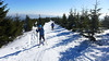


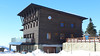


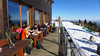


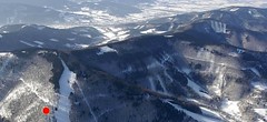
Lysá hora z Papežova, to je beskydská klasika. Kdo nebyl na Lysé, jako by nebyl, to vám řekne každý horal z regionu. Na vrcholu stojí za návštěvu Bezručova chata s vynikající kuchyní i terasou s výhledem.
Peak
- Country
- Czech
- Montains
- Beskydy
- Tags
- Beskydy Czech Republic české hory Lysohoři Moravskoslezské Beskydy Papežov skialpujdoma. Morava
- Hut
- Moravskoslezské Beskydy
- UTM / CH1903 x ("longitude" E/W)
- 34U 315341
- UTM / CH1903 y ("latitude" N/S)
- 5491287
Start point
- Start Point
- Papežov
- Altitude
- 600 m
- UTM / CH1903 x ("longitude" E/W)
- 34U 318786
- UTM / CH1903 y ("latitude" N/S)
- 5490977
Conditions
- Avalanche danger
- Horská služba ČR - Beskydy
- Weather
- Lysá hora 1324 m, meteoblue.com Lysá hora 1324 m, mountain-forecast.com Papežov - Krásná, meteoblue.com Papežov, ventusky.com Javorový vrch, snow-forecast.com Javorový vrch, meteoblue.com Oldřichovice, meteoblue.com Řeka, snow-forecast.com Řeka, meteoblue.com Kozubová 982 m, mountain-forecast.com Kozubová, meteoblue.com Dolní Lomná, meteoblue.com ČHMU - model Aladin Český hydrometeorologický ústav
- Snow report
- Biocel Zlatník, snow.cz Biocel Zlatník, Bergfex.com Grúň Armaturka, snow.cz Horní Lomná - Přelač, snow.cz Milíkov - Kozubová Řeka, snow-forecast.com Řeka, bergfex.com Řeka, snow.cz
- Webcams
- Lysá hora - NW směr (severozápad) Lysá hora - SE směr (jihovýchod) Lysá hora - SW směr (jihozápad) Řeka Javorový vrch
Ski tour map on Lysá hora


 bivakovací nouzová chata
  cepín a mačky potřeba
 exponovaný, obtížný terén
 horská chata
 hôtel, penzion
 lanovka, vlek
 lavinové nebezpečí, svah > 30°
 ledovcové trhliny
 lehká túra
 mimořádně obtížná túra
 mírně obtížná túra
 obtížná túra
 parkoviště
 přístup k chatě
 restaurace
 sedlo
sedlo sjezd
sjezd skidepo
 vrchol
 výstup
 začátek ledovce
- bivouac, winter room
- crampons & ice axe necessary
- exposed, difficulty terrain
- mountain hut, refuge
- hotel, pension
- cableway, skilift
- avalanche danger, slope > 30°
- glacier cracks
- little difficult tour
- extremely difficult tour
- rather difficult tour
- difficult tour
- parking
- hut acces
- restaurant
- col, pass, saddle
- descent
- skidepot
- peak, summit
- ascent
- glacier beginning
- biwak, winterraum
- steigeisen & pickel erforderlich
- ausgesetzt, schwierige gelände
- berghütte
- hotel, pension
- seilbahn, skilift
- lawinengefahr, hangneigung > 30°
- gletscherspalten
- wenig schwierige tour
- äusserst schwierige tour
- ziemlich schwierige tour
- schwierige tour
- parkplatz
- zugang zur hütte
- restaurant
- sattel, joch, pass
- abfahrt
- skidepot
- gipfel
- aufsieg
- gletscher anfang
- bivacco, locale invernale
- ramponi & piccozza necessari
- esposto, terreno difficolt?
- rifugio, capanna
- alberghi, pensione
- funivia, seggiovia
- pericolo di valanghe, pendenza > 30°
- crepe glacier
- tour piccolo difficile
- tour estremamente difficile
- tour piuttosto difficile
- escursioni difficili
- parcheggio
- accesso capanna
- ristorante
- col, sella, passo, forcella
- discesa
- sci deposito
- picco, vertice, piz
- salita
- inizio ghiacciaio
- bivouac, local d'hiver
- crampons & piolet nécessaire
- exposée, difficulté du terrain
- cabane de montagne, refuge
- hôtel, pension
- téléphérique, téléski
- danger d'avalanche, pente > 30°
- crevasse du glacier
- peu difficile tour
- extr?mement difficile tournée
- assez difficile tour
- difficile tournée
- parking
- acces cabane
- restaurant
- col, selle
- descente
- skis dépôt
- pic, sommet
- ascension
- début glacier
- < 20°
- 20° - 25°
- 25° - 30°
- 30° - 35°
- 35° - 40°
- > 40°
Current weather conditions in the tour area
Planning of ski tour
- Fitness difficulty
-
- ♦◊◊◊
- Technical difficulty
-
- ♦◊◊◊
- best time for this tour
- all winter
- Glacier
- No
- Map
- Beskydy jih, Geodezie OnLine, 1:25000 Beskydy sever, Geodezie OnLine, 1:25000 Moravskoslezské Beskydy, KČT, 1:50000 Beskydy, Javorníky lyžařská mapa, Shocart, 1:7550000
- Guides
- Skitour.Guru
About Ski tour
- Time difficulty
- Ascent (height difference)
- 770 m
- Lenght of ascent
- 8,5 km
- Descent (height difference)
- 770 m
- Total Lenght of tour
- 14 km
- Total time of the tour
- 2,5-4 h
- Elevation Range
- 600 - 1323 m
- Principal Aspect
- SE, NE S-south, N-north, W-west, E-east
Download
- GPX (track only)
- LysaH_Papezov_TRACK.gpx best for display on a detailed topographical map (mapy.cz) or in apps for smartphones (Locus, Garmin Connect, etc.)
- GPX (waipoints, track)
- LysaH_Papezov_SKITOUR.gpx great for uploading in GPS device
- KML (with POI)
- LysaHora_SKITOUR.kml for viewing in the Google Earth 3D map application, which you can install on your PC
tour Lysá hora - Reviews
There are no reviews in this section yet. Click the Add Review button to add first review.
Ski tours around Hut Moravskoslezské Beskydy, in mountains Beskydy, Czech
-

Javorový 947 m
Moravskoslezské Beskydy Beskydy Czech
- Length of ascent3,5 km
- ascent500 m
- duration2-2,5 h
- Fitness difficulty ♦◊◊◊
- Technical difficulty ♦◊◊◊
Kopec Javorový je domácí horou pro třinecké horaly. Vede na něj lanovka a dolů z kopce se dá lyžovat po sjezdovce. 500 výškových metrů z Oldřichovic je ideální dávka pro tréninkový fitness skitouring.

-
Řeka - Prislop - Ropička 946 m
Moravskoslezské Beskydy Beskydy Czech
- Length of ascent9,5 km
- ascent830 m
- duration4-6 h
- Fitness difficulty ♦◊◊◊
- Technical difficulty ♦◊◊◊
Oblíbený skiresort Řeka je místem, kde si užijete sjezdu. Po nejdelší beskydské sjezdovce. Hřebenovka přes Prislop a Ropičku vychází z obce Komorní Lhotka.
-
Kozubová 981 m
Moravskoslezské Beskydy Beskydy Czech
- Length of ascent5 km
- ascent490 m
- duration2,5-3 h
- Fitness difficulty ♦◊◊◊
- Technical difficulty ♦◊◊◊