
 Česky
Česky Deutsch


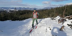
Zajímavosti na trase: Vyhlídka u Kapličky Strčková. Vrchol Javorníček. Kaplička Javorníček. Kaplička Koncová. Vrchol Koncová. Začínáme u Hospody Kyčerka ve Velkých Karlovicích. Vystoupáme po trase Bike trails Valašsko nebo po okraji lesa u modré sjezdovky lyžařského areálu na hřeben. Po výstupu z lesa jdeme po loukách kolem vyhlídkového místa u Kapličky Strčková, dále po trase Bike trails Valašsko až na žlutou turistickou značku, po které se dostaneme přes vrchol Javorníček a stejnojmenné kaple do sedla Příschlop. Z něj vystoupáme na vrchol hory Gigula (951 mnm). Z Giguly se přesuneme po zelené značce na vrchol Koncová (895 mnm) a odtud sjíždíme po loukách kolem Kapličky Koncová zpět do údolí v Pluskovci.
Peak
- Country
- Czech
- Montains
- Javorníky - Valašsko
- Tags
- české hory fitness skitouring Javorníky Kyčerka moravský skitouring skialpujdoma Valašsko
- Hut
- Javorníky - Valašsko
- UTM / CH1903 x ("longitude" E/W)
- 34U 305092
- UTM / CH1903 y ("latitude" N/S)
- 5467440
Start point
- Start Point
- Kyčerka - parkoviště
- Altitude
- 560 m
- UTM / CH1903 x ("longitude" E/W)
- 34U 303605
- UTM / CH1903 y ("latitude" N/S)
- 5470077
- Photo by
- Roman Kalabus, baobabtrails.com, www.baobabtrails.com
- Participed on tour mapping
- Roman Kalabus, SkitourInValašsko, skitourinvalassko.cz
Conditions
- Avalanche danger
- Horská služba ČR - Beskydy
- Weather
- Velké Karlovice, meteoblue.com Velké Karlovice, ventusky.com Kyčerka, snow-forecast.com Kohútka, snow-forecast.com Razula, snow-forecast.com Karolinka, meteoblue.com Soláň, snow-forecast.com Soláň, meteoblue.com Zděchov, meteoblue.com ČHMU - model Aladin Český hydrometeorologický ústav
- Snow report
- Kohútka, snow.cz Kohútka, Bergfex.com Kohútka, snow-forecast.com Razula, snow-forecast.com Razula, bergfex.com Razula, snow.cz Soláň, snow-forecast.com Soláň, snow.cz Karolinka, snow.cz Kyčerka, snow.cz Kyčerka, snow-forecast.com Kyčerka, bergfex.com
- Webcams
- Kohútka - 8x webcam Kyčerka Razula Soláň Karolinka Velké Karlovice
Ski tour map on Kolem kapliček javornickými kopci


 bivakovací nouzová chata
  cepín a mačky potřeba
 exponovaný, obtížný terén
 horská chata
 hôtel, penzion
 lanovka, vlek
 lavinové nebezpečí, svah > 30°
 ledovcové trhliny
 lehká túra
 mimořádně obtížná túra
 mírně obtížná túra
 obtížná túra
 parkoviště
 přístup k chatě
 restaurace
 sedlo
sedlo sjezd
sjezd skidepo
 vrchol
 výstup
 začátek ledovce
- bivouac, winter room
- crampons & ice axe necessary
- exposed, difficulty terrain
- mountain hut, refuge
- hotel, pension
- cableway, skilift
- avalanche danger, slope > 30°
- glacier cracks
- little difficult tour
- extremely difficult tour
- rather difficult tour
- difficult tour
- parking
- hut acces
- restaurant
- col, pass, saddle
- descent
- skidepot
- peak, summit
- ascent
- glacier beginning
- biwak, winterraum
- steigeisen & pickel erforderlich
- ausgesetzt, schwierige gelände
- berghütte
- hotel, pension
- seilbahn, skilift
- lawinengefahr, hangneigung > 30°
- gletscherspalten
- wenig schwierige tour
- äusserst schwierige tour
- ziemlich schwierige tour
- schwierige tour
- parkplatz
- zugang zur hütte
- restaurant
- sattel, joch, pass
- abfahrt
- skidepot
- gipfel
- aufsieg
- gletscher anfang
- bivacco, locale invernale
- ramponi & piccozza necessari
- esposto, terreno difficolt?
- rifugio, capanna
- alberghi, pensione
- funivia, seggiovia
- pericolo di valanghe, pendenza > 30°
- crepe glacier
- tour piccolo difficile
- tour estremamente difficile
- tour piuttosto difficile
- escursioni difficili
- parcheggio
- accesso capanna
- ristorante
- col, sella, passo, forcella
- discesa
- sci deposito
- picco, vertice, piz
- salita
- inizio ghiacciaio
- bivouac, local d'hiver
- crampons & piolet nécessaire
- exposée, difficulté du terrain
- cabane de montagne, refuge
- hôtel, pension
- téléphérique, téléski
- danger d'avalanche, pente > 30°
- crevasse du glacier
- peu difficile tour
- extr?mement difficile tournée
- assez difficile tour
- difficile tournée
- parking
- acces cabane
- restaurant
- col, selle
- descente
- skis dépôt
- pic, sommet
- ascension
- début glacier
- < 20°
- 20° - 25°
- 25° - 30°
- 30° - 35°
- 35° - 40°
- > 40°
Current weather conditions in the tour area
Planning of ski tour
- Fitness difficulty
-
- ♦◊◊◊
- Technical difficulty
-
- ♦◊◊◊
- best time for this tour
- all winter
- Glacier
- No
- Map
- Javorníky - západ, list 95, KČT, 1:50000 Beskydy, Javorníky lyžařská mapa, Shocart, 1:7500000
- Guides
- Skitour.Guru SkitourInValassko.cz
About Ski tour
- Time difficulty
- Ascent (height difference)
- 480 m
- Lenght of ascent
- 6 km
- Descent (height difference)
- 480 m
- Total Lenght of tour
- 9 km
- Total time of the tour
- 3-4 h
- Elevation Range
- 560 - 951 m
- Principal Aspect
- N, NW, SE S-south, N-north, W-west, E-east
Download
- GPX (track only)
- JAV_Kycerka_Kapličky okruh TRK.gpx best for display on a detailed topographical map (mapy.cz) or in apps for smartphones (Locus, Garmin Connect, etc.)
- GPX (waipoints, track)
- Javorniky-kaplicky_SKITOUR.gpx great for uploading in GPS device
- KML (with POI)
- JavornickeKaplicky_Kycerka_SKITOUR.kml for viewing in the Google Earth 3D map application, which you can install on your PC
tour Kolem kapliček javornickými kopci - Reviews
There are no reviews in this section yet. Click the Add Review button to add first review.
Ski tours around Hut Javorníky - Valašsko, in mountains Javorníky - Valašsko, Czech
-
Okolo Vsackého Cábu 830 m
Javorníky - Valašsko Javorníky - Valašsko Czech
- Length of ascent5 km
- ascent320 m
- duration1,5-2,5 h
- Fitness difficulty ♦◊◊◊
- Technical difficulty ♦◊◊◊
Zajímavosti na trase: Horský hotel Vsacký Cáb (jedna z prvních horských chat KČT v Beskydech 1927-28). Cábské jezírko (vzniklo při sesuvu, který přehradil jeden z přítoků Malé Bystřičky). Vyhlídka na vrcholu sjezdovky na Vsackém Cábu. Z parkoviště u Horského hotelu Vsacký Cáb se vydáme po červené turistické značce směrem na rozcestí Ptáčnice. Zde odbočíme doleva a po žluté značce. Po jednom kilometru odbočíme z hřebene na Baťovu NS směrem k Cábskému jezeru. Zpáteční cesta od jezera vede po stejné trase zpět na žlutou značku. Po ní jdeme cca 300 metrů a odbočíme na trasu běžecké zimní trasy. Po ní se vrátíme zpět k chatě na Cábu a ještě než u ní ukončíme skitouringovou trasu, vyjdeme nad hotelem na vrcholek sjezdovky. Tu sjedeme a vrátíme se zpět k chatě.

-
Zděchovské lúky 725 m
Javorníky - Valašsko Javorníky - Valašsko Czech
- Length of ascent2,5 km
- ascent290 m
- duration2-3 h
- Fitness difficulty ♦◊◊◊
- Technical difficulty ♦◊◊◊
Zajímavosti na trase: Vodní prvek – studánka Zděchov. Zajímavosti na trase: Vodní prvek – studánka Zděchov. Vyhlídkové místo Zděchov. Sedlo Radošov. Trasa vede z parkoviště u fotbalového hřiště ve Zděchově. Kolem asfaltové silničky k prvnímu mostku přes potok po trase NS Zděchov. Za mostkem po louce stoupáme přímo vzhůru, až narazíme na zelenou turistickou značku. Před začátkem lesa uhneme doleva na louku a kolem lesa stoupáme po loukách s lesem po pravé ruce k vyhlídkovému místu Zděchov, které je součástí NS Zděchov. Po Naučné stezce Zděchov pokračujeme do rozcestí Radošov. Od něj se vydáme zpět do Zděchova po červené značce cca 200 metrech prosvítajícím lesem vyjdeme zpět na louky. Nastoupáme 30 výškových metrů a spustíme se po loukách na kótu 590 mnm. Z tohoto vrcholku pak sjedeme kolem lyžařského vleku zpět k parkovišti.
-
Z Karolinky přes Kání na Kyčerku 744 m
Javorníky - Valašsko Javorníky - Valašsko Czech
- Length of ascent3,5 km
- ascent370 m
- duration1,5-2,5 h
- Fitness difficulty ♦◊◊◊
- Technical difficulty ♦◊◊◊
Trasa začíná výstupem na pravé straně kolem lesa lyžařského areálu v Karolince. Stoupáme po loukách mimo sjezdovku na její vrchol. Mineme lyžařský vlek a jdeme k vrcholu Kání (744 m). Postupujeme po lesní cestě a na kótě 49.3375681N, 18.2758492E můžeme odbočit na vrchol 764 mnm o souřadnicích 49.3368411N, 18.2777589E. Sjedeme po louce na lesní cestu, ze které si můžeme cca 150 metrů odbočit na vyhlídku u Kapličky Strčková. Od ní se vydáme po trase Bike trails Valašsko do lyžařského areálu Kyčerka ve Velkých Karlovicích. Po sjezdovce sjedeme dolů k hospodě Kyčerka či na spodní parkoviště areálu, cca 300 metrů od vlakové zastávky. Trasu je možno jít i opačným směrem. Zajímavosti na trase: Restaurace u Vleku v Karolince. Lyžařská areál Karolinka s největším snowparkem v Beskydech. Vyhlídkové místo na vrcholu Kání 744 mnm. Kaplička Strčková. Hospoda Kyčerka ve Velkých Karlovicích.
-
Rozhledna Miloňová 846 m
Javorníky - Valašsko Javorníky - Valašsko Czech
- Length of ascent6 km
- ascent440 m
- duration2,5-4 h
- Fitness difficulty ♦◊◊◊
- Technical difficulty ♦◊◊◊
Trasa začíná na parkovišti u Hotelu Galík. Případně u Ski areálu Razula. Odtud se vydáme po modré turistické značce k parkovišti Malá Hanzlůvka. Zde se otočíme téměř o 180 stupňů doleva a vydáme se po červené cyklotrase po cestě zvané Škaredica na rozcestí Nad Lanternou. Zde pokračujeme vpravo po značce vedoucí k rozhledně Miloňová. Z Miloňové po svážnicových cestách doleva zpět na trasu cykotrasy, kde se začneme vracet k místu startu. U rozcestí Nad Lanternou pak můžeme sundat z lyží pásy a vydat se po bývalé sjezdovce sjezdem zpět k autu.
-

Kohútí stopou - Kohútka 900 m
Javorníky - Valašsko Javorníky - Valašsko Czech
- Length of ascent4,5 km
- ascent470 m
- duration3-4 h
- Fitness difficulty ♦◊◊◊
- Technical difficulty ♦◊◊◊
Zajímavosti na trase: Kříž lidí dobré vůle z roku 1935. Horský hotel Kohútka známý jedinečnými borůvkovými knedlíky. Horský hotel Portáš s poštovnou. Trasa vede z parkoviště ve Vranči po louce kolem nádrže U Javoru k nástupní stanici lanovky na Kohútce. Po okraji modré sjezdovky zvané Babská na malý hřeben lemující tuto sjezdovku. Po okraji sjezdovky vejdeme na louku a vystoupáme až ke kříži u žluté turistické značky. Od Kříže se vydáme po červené značce směrem k Horskému hotelu Kohútka. Dále vede trasa stále v blízkosti červené turistické značky kolem lesa u sjezdovky Barborka, dále kolem sjezdovky Spartak až ke sjezdovce Seník. Tu sjedeme na křížení s modrou značkou vedoucí k Horskému hotelu Portáš. Právě kolem něj se dostaneme na propojovací lesní cestu cca v polovině sjezdovky na Portáši, kterou dojdeme pod Vrch Stolečný. Po jeho zdolání se vydáme opět kolem Hotelu Portáš tentokrát po hřebenové červené značce k sjezdovce Seník. Tu sjedeme opět na modrou turistickou značku a vydáme se tentokrát v opačném směru do údolí Vranča.