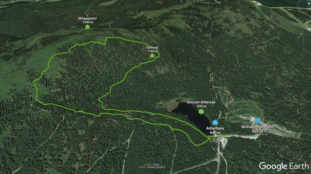
Peak
- Country
- Germany
- Montains
- Bóhmerwald
- Tags
- Bayerisch Eisenstein Bayerischer Wald Bayern Böhmerwald Deutschland Šumava
- Hut
- Arberland - Bayerisch Eisenstein
- UTM / CH1903 x ("longitude" E/W)
- 33U 364413
- UTM / CH1903 y ("latitude" N/S)
- 5439477
Start point
- Start Point
- Skistadion Hohenzoll / Grosser Arbersee
- Altitude
- 960 m
- UTM / CH1903 x ("longitude" E/W)
- 33U 365737
- UTM / CH1903 y ("latitude" N/S)
- 5440322
- village, valley
- Bayerisch Eisenstein
Conditions
- Avalanche danger
- Lawinenwarnzentrale Bayern
- Weather
- Grosser Arber, mountain-forecast.com Grosser Arber, snow-forecast.com Grosser Arber, wetteronline.de Grosser Arber, meteoblue.com Bayerisch Eisenstein, meteoblue.com Bayerisch Eisenstein, ventusky.com
- Snow report
- Grosser Arber, snow-forecast.com Grosser Arber, snow.cz Grosser Arber, bergfex.com Grosser Arber, onthesnow.com
- Webcams
- Grosser Arber skiresort 7x
Planning of ski tour
- Fitness difficulty
-
- ♦◊◊◊
- Technical difficulty
-
- ♦◊◊◊
- best time for this tour
- all winter
- Glacier
- No
- Map
- Šumava - Železnorudsko, 1:25000, Nr. 93, Geodézie On-Line Nördlicher Bayerischer Wald, 1:50000, Nr. 195 Kompass
About Ski tour
- Time difficulty
- Ascent (height difference)
- 500 m
- Lenght of ascent
- 3 km
- Descent (height difference)
- 500 m
- Total Lenght of tour
- 5,5 km
- Total time of the tour
- 1,5-2,5 h
- Elevation Range
- 945 - 1340 m
- Principal Aspect
- S-south, N-north, W-west, E-east
Download
- GPX (track only)
- Seewand_Gr-Arbersee_TRACK.gpx best for display on a detailed topographical map (mapy.cz) or in apps for smartphones (Locus, Garmin Connect, etc.)
- GPX (waipoints, track)
- Mittagspl-Seewand_SKITOUR.gpx great for uploading in GPS device
tour Seewand - Mittagsplatzl - Reviews
There are no reviews in this section yet. Click the Add Review button to add first review.
Ski tours around Hut Arberland - Bayerisch Eisenstein, in mountains Bóhmerwald, Germany
-

Grosser Arber 1456 m
Arberland - Bayerisch Eisenstein Bóhmerwald Germany
- Length of ascent6 km
- ascent650 m
- duration2,5-3,5 h
- Fitness difficulty ♦◊◊◊
- Technical difficulty ♦◊◊◊

-

Grosser Arber Runde 1456 m
Arberland - Bayerisch Eisenstein Bóhmerwald Germany
- Length of ascent5 km
- ascent795 m
- duration3-4 h
- Fitness difficulty ♦♦◊◊
- Technical difficulty ♦◊◊◊


 Česky
Česky Deutsch


