
 Česky
Česky Deutsch


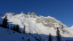
Grosser Drusenturm is a very challenging ski tour in Ratikon, Austria (Montafon, Vorarlberg) from Lindauer Hütte to the rocky peak of Grosser Drusenturm. Due to a very steep, 300-meter altitude below the summit, it can be realized only under excellent conditions (weather, stable snow).
Peak
- Country
- Austria
- Montains
- Rätikon
- Tags
- Lindauer Hütte Montafon Rätikon Sporertal
- Hut
- Lindauer Hütte
- UTM / CH1903 x ("longitude" E/W)
- 32T 563488
- UTM / CH1903 y ("latitude" N/S)
- 5209331
Start point
- Start Point
- Lindauer Hütte
- Altitude
- 1755 m
- UTM / CH1903 x ("longitude" E/W)
- 32T 563488
- UTM / CH1903 y ("latitude" N/S)
- 5209331
- village, valley
- Latschau - Gauertal
Conditions
- Avalanche danger
- LWD Vorarlberg
- Weather
- Alpenverein ZAMG ORF Wetter yr.no - Lindauer Hütte yr.no - Sulzfluh
- Snow report
- Golm - snow-forecast.com Golm - bergfex.at Golm - schneeradar.de
- Webcams
- Golm - Grüneck Partnun (CH, Graubünden)
Ski tour map on Grosser Drusenturm - Drei Türme


 bivakovací nouzová chata
  cepín a mačky potřeba
 exponovaný, obtížný terén
 horská chata
 hôtel, penzion
 lanovka, vlek
 lavinové nebezpečí, svah > 30°
 ledovcové trhliny
 lehká túra
 mimořádně obtížná túra
 mírně obtížná túra
 obtížná túra
 parkoviště
 přístup k chatě
 restaurace
 sedlo
sedlo sjezd
sjezd skidepo
 vrchol
 výstup
 začátek ledovce
- bivouac, winter room
- crampons & ice axe necessary
- exposed, difficulty terrain
- mountain hut, refuge
- hotel, pension
- cableway, skilift
- avalanche danger, slope > 30°
- glacier cracks
- little difficult tour
- extremely difficult tour
- rather difficult tour
- difficult tour
- parking
- hut acces
- restaurant
- col, pass, saddle
- descent
- skidepot
- peak, summit
- ascent
- glacier beginning
- biwak, winterraum
- steigeisen & pickel erforderlich
- ausgesetzt, schwierige gelände
- berghütte
- hotel, pension
- seilbahn, skilift
- lawinengefahr, hangneigung > 30°
- gletscherspalten
- wenig schwierige tour
- äusserst schwierige tour
- ziemlich schwierige tour
- schwierige tour
- parkplatz
- zugang zur hütte
- restaurant
- sattel, joch, pass
- abfahrt
- skidepot
- gipfel
- aufsieg
- gletscher anfang
- bivacco, locale invernale
- ramponi & piccozza necessari
- esposto, terreno difficolt?
- rifugio, capanna
- alberghi, pensione
- funivia, seggiovia
- pericolo di valanghe, pendenza > 30°
- crepe glacier
- tour piccolo difficile
- tour estremamente difficile
- tour piuttosto difficile
- escursioni difficili
- parcheggio
- accesso capanna
- ristorante
- col, sella, passo, forcella
- discesa
- sci deposito
- picco, vertice, piz
- salita
- inizio ghiacciaio
- bivouac, local d'hiver
- crampons & piolet nécessaire
- exposée, difficulté du terrain
- cabane de montagne, refuge
- hôtel, pension
- téléphérique, téléski
- danger d'avalanche, pente > 30°
- crevasse du glacier
- peu difficile tour
- extr?mement difficile tournée
- assez difficile tour
- difficile tournée
- parking
- acces cabane
- restaurant
- col, selle
- descente
- skis dépôt
- pic, sommet
- ascension
- début glacier
- < 20°
- 20° - 25°
- 25° - 30°
- 30° - 35°
- 35° - 40°
- > 40°
Current weather conditions in the tour area
Planning of ski tour
- Fitness difficulty
-
- ♦♦♦◊
- Technical difficulty
-
- ♦♦♦◊
- best time for this tour
- March-April
- Glacier
- No
- Map
- Montafon 238 S, Swisstopo - Skitourenkarte, 1:50000 Sulzfluh 1157, Swisstopo - Landeskarten, 1:25000
- Guides
- Vorarlberg (deutsch, Rother Skitourenführer) Das perfekte Skitouren-Wochenende (deutsch, Rother Skitourenführer)
About Ski tour
- Time difficulty
- Ascent (height difference)
- 1090 m
- Lenght of ascent
- 5,5 km
- Descent (height difference)
- 1090 m
- Total Lenght of tour
- 11 km
- Total time of the tour
- 4-6 h
- Elevation Range
- 1740 - 2830 m
- Principal Aspect
- N, SE S-south, N-north, W-west, E-east
Download
- GPX (track only)
- GrDrusenturm_LindauerHte_TRACKkml.gpx best for display on a detailed topographical map (mapy.cz) or in apps for smartphones (Locus, Garmin Connect, etc.)
- GPX (waipoints, track)
- GrDrusenturm-SkitourGuru.gpx great for uploading in GPS device
- KML (with POI)
- GROSSER DRUSENTURM_tour.kml for viewing in the Google Earth 3D map application, which you can install on your PC
Current avalanche potential on tour - Grosser Drusenturm - Drei Türme

tour Grosser Drusenturm - Drei Türme - Reviews
There are no reviews in this section yet. Click the Add Review button to add first review.
Ski tours around Hut Lindauer Hütte, in mountains Rätikon, Austria
-
Drusator 2364 m
Lindauer Hütte Rätikon Austria
- Length of ascent4 km
- ascent592 m
- duration2-3,5 h
- Fitness difficulty ♦♦◊◊
- Technical difficulty ♦♦◊◊
Drusator is a medium difficult ski tour of the austrian Rätikon (Montafon, Vorarlberg) from Lindauer Hütte to the Drusator saddle. Over the saddle you can reach the Partnun on the swiss side of Rätikon (Berghaus Sulzfluh, Carschina Hütte).

-

Sulzfluh N 2818 m
Lindauer Hütte Rätikon Austria
- Length of ascent5,5 km
- ascent1300 m
- duration5-7 h
- Fitness difficulty ♦♦♦◊
- Technical difficulty ♦♦♦◊
Sulzfluh (Lindauer Hütte, Rätikon) is a very challenging ski tour through the rocky slopes "In der Rachen" (in the throat). From the top are great views of the mountains of eastern Switzerland and Silvretta.