
 Česky
Česky Deutsch


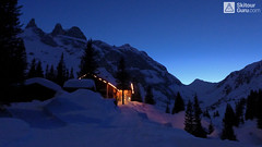


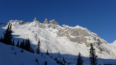
Lindauer Hütte is hut under the impressive dolomite rock towers of Rätikon, on the borders of Austria and Switzerland. Nearby is the Golm Ski Resort in Montafon. Two great skitours in the shadow of the rock towers at Sulzfluh and Drusenturm - both can only be done under excellent conditions. You can also cross the Drusator saddle to the swiss side of Rätikon.
Tours starting from hut
Ski tours around Hut Lindauer Hütte
-
Drusator 2364 m
Lindauer Hütte Rätikon Austria
- Length of ascent4 km
- ascent592 m
- duration2-3,5 h
- Fitness difficulty ♦♦◊◊
- Technical difficulty ♦♦◊◊
Drusator is a medium difficult ski tour of the austrian Rätikon (Montafon, Vorarlberg) from Lindauer Hütte to the Drusator saddle. Over the saddle you can reach the Partnun on the swiss side of Rätikon (Berghaus Sulzfluh, Carschina Hütte).

-

Grosser Drusenturm - Drei Türme 2830 m
Lindauer Hütte Rätikon Austria
- Length of ascent5,5 km
- ascent1090 m
- duration4-6 h
- Fitness difficulty ♦♦♦◊
- Technical difficulty ♦♦♦◊
Grosser Drusenturm is a very challenging ski tour in Ratikon, Austria (Montafon, Vorarlberg) from Lindauer Hütte to the rocky peak of Grosser Drusenturm. Due to a very steep, 300-meter altitude below the summit, it can be realized only under excellent conditions (weather, stable snow).
-

Sulzfluh N 2818 m
Lindauer Hütte Rätikon Austria
- Length of ascent5,5 km
- ascent1300 m
- duration5-7 h
- Fitness difficulty ♦♦♦◊
- Technical difficulty ♦♦♦◊
Sulzfluh (Lindauer Hütte, Rätikon) is a very challenging ski tour through the rocky slopes "In der Rachen" (in the throat). From the top are great views of the mountains of eastern Switzerland and Silvretta.
- Country
- Austria
- Montains
- Rätikon
- Open (winter)
- 20.12-11.1. , end of January to mid March
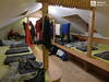
- Beds
- 200
- Winterraum
- 0
- Shortening of access (cableway, lift, taxi, snowcat...)
- no
- UTM / CH1903 x ("longitude" E/W)
- 32T 563488
- UTM / CH1903 y ("latitude" N/S)
- 5209331
- GPX access to hut (waipoints, track)
- Lindauer-Huette-access-SkitourGuru.gpx
- GPX all tours from the hut
- Lindauer Huette AUT RATIKON skitourguru.gpx
- Map
- Montafon 238 S, Swisstopo - Skitourenkarte, 1:50000 Sulzfluh 1157, Swisstopo - Landeskarten, 1:25000 Schesaplana 1156, Swisstopo - Landeskarten, 1:25000
- Guides
- Vorarlberg (deutsch, Rother Skitourenführer) Das perfekte Skitouren-Wochenende (deutsch, Rother Skitourenführer) Die schönsten Skidurchquerungen in den Alpen (deutsch, Bruckmann Verlag)
- Phone (hut)
- 0043 664 5033456
- Phone (valley)
- 00435559582
- Cell phone
- -
- Web
- www.lindauerhuette.at
- lindauerhuette@aon.at
- Owner of hut
- DAV Sektion Lindau
- Start Point
- Latschau / Golmerbahn lower station
- UTM / CH1903 x ("longitude" E/W)
- 32T 566509
- UTM / CH1903 y ("latitude" N/S)
- 5213651
- Altitude
- 1000 m
- Ascent (height difference)
- 755 m
- Time of Access
- 2-3 h
- Shortening lift
- no
- Avalanche danger
- LWD Vorarlberg
- Weather
- Alpenverein ZAMG ORF Wetter yr.no - Lindauer Hütte yr.no - Sulzfluh
- Snow report
- Golm - snow-forecast.com Golm - bergfex.at Golm - schneeradar.de
- Webcams
- Golm - Grüneck Partnun (CH, Graubünden)
- Region
- Vorarlberg Tourism Montafon
- Public traffic
- Postbus Österreichische Bahn
- Skiresort nearby
- Golm Gargellen Silvretta - Montafon
hut Lindauer Hütte - Reviews
There are no reviews in this section yet. Click the Add Review button to add first review.
Best ski tours in Austria by skitour.guru
-

Festkogel 2269 m
Johnsbach - Kölblwirt Gesäuse Austria
- Length of ascent5,5 km
- ascent1430 m
- duration6-8 h
- Fitness difficulty ♦♦♦◊
- Technical difficulty ♦♦♦◊
Festkogel is a very attractive ski tour between the rocks with a breathtaking view of the whole Gesäuse and the Enns valley. From the parking (of the Hesshütte), nearby the restaurant and Hotel Kölblwirt towards the waterfall along the trail. Continue through a steep narrow rock ditch towards the tower Schneekarturm. Around the tower until the last part of the climb. By frequent crossing of steep slopes, the Festkogel is recommended a ski trip in stable conditions.
-
Grosser Geiger SW 3360 m
Essener-Rostocker Hütte Venedigergruppe - Hohe Tauern Austria
- Length of ascent7,5 km
- ascent1090 m
- duration5,5-7 h
- Fitness difficulty ♦♦♦◊
- Technical difficulty ♦♦♦◊
Favorite ski tour from Essener-Rostocker Hütte. Climbing the Grosser Geiger from the south leads along the Maurerkees glacier. At 2650 meters, the route turns north-westward and heads a rather steep slope towards the flat upper glacier. There is skidepo under the top pyramid. On the top of the undemanding terrain in crampons and ice axe. Follow the same route to hut.
-

Lugauer 2206 m
Johnsbach - Kölblwirt Gesäuse Austria
- Length of ascent11 km
- ascent1680 m
- duration6,5-8,5 h
- Fitness difficulty ♦♦♦♦
- Technical difficulty ♦♦♦◊
Lugauer is a distinctive mountain rightfully called Styrian Matterhorn. Ascent is long, due to elevation and length, so it is good fitness advantage. Excellent experience promises a conclusion ascent over the forest. Finish on the ridge in the crampons.