
 Česky
Česky Deutsch


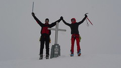


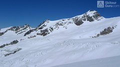
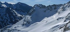
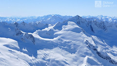
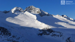
Favorite ski tour from Essener-Rostocker Hütte. Climbing the Grosser Geiger from the south leads along the Maurerkees glacier. At 2650 meters, the route turns north-westward and heads a rather steep slope towards the flat upper glacier. There is skidepo under the top pyramid. On the top of the undemanding terrain in crampons and ice axe. Follow the same route to hut.
Peak
- Country
- Austria
- Montains
- Venedigergruppe - Hohe Tauern
- Tags
- Austria Essener-Rostocker Hütte Hohe Tauern Osttirol Venedigergruppe Virgental
- Hut
- Essener-Rostocker Hütte
- UTM / CH1903 x ("longitude" E/W)
- 33 T 295757
- UTM / CH1903 y ("latitude" N/S)
- 5219044
Start point
Conditions
- Avalanche danger
- lawine.at
- Weather
- Essener-Rostocker Hütte / meteoblue.com Dreiherrnspitze / mountain-forecast.com Ochsenbug / mountain-forecast.com Bergwetter Tirol 2 days / orf.at Essener-Rostocker Hütte / yr.no Ostalpen / alpenverein.at (de) Tirol / orf.at Austria / ZAMG.ac.at
- Snow report
- Dreiherrnspitze / mountain-forecast.com St. Jakob in Deferegtal /bergfex.at St. Jakob in Deferegtal / onthesnow.com
- Webcams
- Essener-Rostocker Hütte
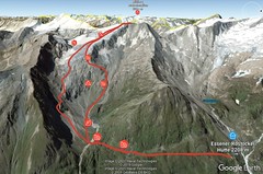
Ski tour map on Grosser Geiger SW


 bivakovací nouzová chata
  cepín a mačky potřeba
 exponovaný, obtížný terén
 horská chata
 hôtel, penzion
 lanovka, vlek
 lavinové nebezpečí, svah > 30°
 ledovcové trhliny
 lehká túra
 mimořádně obtížná túra
 mírně obtížná túra
 obtížná túra
 parkoviště
 přístup k chatě
 restaurace
 sedlo
sedlo sjezd
sjezd skidepo
 vrchol
 výstup
 začátek ledovce
- bivouac, winter room
- crampons & ice axe necessary
- exposed, difficulty terrain
- mountain hut, refuge
- hotel, pension
- cableway, skilift
- avalanche danger, slope > 30°
- glacier cracks
- little difficult tour
- extremely difficult tour
- rather difficult tour
- difficult tour
- parking
- hut acces
- restaurant
- col, pass, saddle
- descent
- skidepot
- peak, summit
- ascent
- glacier beginning
- biwak, winterraum
- steigeisen & pickel erforderlich
- ausgesetzt, schwierige gelände
- berghütte
- hotel, pension
- seilbahn, skilift
- lawinengefahr, hangneigung > 30°
- gletscherspalten
- wenig schwierige tour
- äusserst schwierige tour
- ziemlich schwierige tour
- schwierige tour
- parkplatz
- zugang zur hütte
- restaurant
- sattel, joch, pass
- abfahrt
- skidepot
- gipfel
- aufsieg
- gletscher anfang
- bivacco, locale invernale
- ramponi & piccozza necessari
- esposto, terreno difficolt?
- rifugio, capanna
- alberghi, pensione
- funivia, seggiovia
- pericolo di valanghe, pendenza > 30°
- crepe glacier
- tour piccolo difficile
- tour estremamente difficile
- tour piuttosto difficile
- escursioni difficili
- parcheggio
- accesso capanna
- ristorante
- col, sella, passo, forcella
- discesa
- sci deposito
- picco, vertice, piz
- salita
- inizio ghiacciaio
- bivouac, local d'hiver
- crampons & piolet nécessaire
- exposée, difficulté du terrain
- cabane de montagne, refuge
- hôtel, pension
- téléphérique, téléski
- danger d'avalanche, pente > 30°
- crevasse du glacier
- peu difficile tour
- extr?mement difficile tournée
- assez difficile tour
- difficile tournée
- parking
- acces cabane
- restaurant
- col, selle
- descente
- skis dépôt
- pic, sommet
- ascension
- début glacier
- < 20°
- 20° - 25°
- 25° - 30°
- 30° - 35°
- 35° - 40°
- > 40°
Current weather conditions in the tour area
Planning of ski tour
- Fitness difficulty
-
- ♦♦♦◊
- Technical difficulty
-
- ♦♦♦◊
- best time for this tour
- March-April
- Glacier
- Yes
- Map
- Venedigergruppe, OEAV 1:25000, Nr. 36 Wege und Skitouren
- Guides
- Skitourenführer Hohe Tauern / Panico, deutsch Schitouren-Atlas ÖSTERREICH WEST / SchallVerlag, deutsch Hohe Tauern (Bergverlag Rother)
About Ski tour
- Time difficulty
- Ascent (height difference)
- 1090 m
- Lenght of ascent
- 7,5 km
- Descent (height difference)
- 1090 m
- Total Lenght of tour
- 14 km
- Total time of the tour
- 5,5-7 h
- Elevation Range
- 2208 - 3360 m
- Principal Aspect
- South, West S-south, N-north, W-west, E-east
Download
- GPX (track only)
- GrGeiger-SW_TRACK.gpx best for display on a detailed topographical map (mapy.cz) or in apps for smartphones (Locus, Garmin Connect, etc.)
- GPX (waipoints, track)
- Gr-Geiger_Essen-Rost-Hut_skitour.gpx great for uploading in GPS device
- KML (with POI)
- GrosserGeiger 3360m skitour.kml for viewing in the Google Earth 3D map application, which you can install on your PC
Current avalanche potential on tour - Grosser Geiger SW

tour Grosser Geiger SW - Reviews
There are no reviews in this section yet. Click the Add Review button to add first review.
Ski tours around Hut Essener-Rostocker Hütte, in mountains Venedigergruppe - Hohe Tauern, Austria
-

Westliche Simonyspitze 3488 m
Essener-Rostocker Hütte Venedigergruppe - Hohe Tauern Austria
- Length of ascent5 km
- ascent1400 m
- duration6,5-8,5 h
- Fitness difficulty ♦♦♦◊
- Technical difficulty ♦♦♦◊
Westliche Simonyspitze is a great alpine ski tour with a view of the Dreiherrnspitze. First, it rises to Reggentörl. Short downhill and follow the Umbalkees Glacier up. The ascent to the top is usually without skis. Downhill is great especially for firn.

-
Dreiherrnspitze 3499 m
Essener-Rostocker Hütte Venedigergruppe - Hohe Tauern Austria
- Length of ascent8,6 km
- ascent1430 m
- duration9-11 h
- Fitness difficulty ♦♦♦♦
- Technical difficulty ♦♦♦◊
The Dreiherrnspitze is a spectacular, complex and challenging glacier ski tour. Especially difficult is its length, glacial cracks and terrain break at the end. First, it is easy to climb glacier the Südl. Malhamkees to Regentörl saddle. After a short downhill northwards to the Umbalkees Glacier, the traverse between the cracks and then to the Althauskees. Relatively steep slope to difficult terrain break (depending on snow conditions). After overcoming it, there is only 200 high meters in easy terrain. Downhill same track as ascent.
-
Mittlere Malmhalmspitze 3364 m
Essener-Rostocker Hütte Venedigergruppe - Hohe Tauern Austria
- Length of ascent km
- ascent1165 m
- duration6-8 h
- Fitness difficulty ♦♦♦◊
- Technical difficulty ♦♦♦◊
Mittlere Malmhalmspitze is a Skitour known for its excellent downhill ride, which can be extended to the Virgental Valley. A shorter yet physically demanding tour. From the Essener-Rostocker Hütte first south towards Maurer Alm and then west to the Nördlliches Malhamkees glacier. Cross the slope "Böse Wand" to the top.
-
Rostocker Eck 2749 m
Essener-Rostocker Hütte Venedigergruppe - Hohe Tauern Austria
- Length of ascent km
- ascent550 m
- duration h
- Fitness difficulty ♦♦◊◊
- Technical difficulty ♦♦◊◊
Rostocker Eck is a warm-up ski tour near the Essener-Rostocker Hütte. it is a tour, usually rising up the northern slope and descending the southern slope. Excellent lookout tower 550 m above the hut.
Best ski tours in Venedigergruppe - Hohe Tauern by skitour.guru
-
Schlieferspitze 3289 m
Kürsinger Hütte Venedigergruppe - Hohe Tauern Austria
- Length of ascent7,5 km
- ascent1050 m
- duration5-6,5 h
- Fitness difficulty ♦♦♦◊
- Technical difficulty ♦♦♦◊
Relatively demanding glacier ski tour on 3289 m Schlieferspitze leads glacial terrain. To stay on Kürsinger Hut fits is Schlieferspitze ideal tour for the last day. After ascent to descent the eastern slopes and valleys Sulzbachtal the parking lot. When staying overnight at Postalm is actually the only option for the ascent.
-

Keeskogel 3291 m
Kürsinger Hütte Venedigergruppe - Hohe Tauern Austria
- Length of ascent3 km
- ascent830 m
- duration3-4,5 h
- Fitness difficulty ♦♦◊◊
- Technical difficulty ♦♦♦◊
A shorter skitour on the lookout Keeskogel provides a fantastic panorama of the whole area of the main alpine ridge. Hohe Tauern at your fingertips - Grossvenediger, Grosser Geiger and Schlieferspitze. Final exposed ridge climbing requires little skill, dificulty I to II. UIAA. Much depends on snow conditions.
-
Grossvenediger N (Kürsinger H.) 3666 m
Kürsinger Hütte Venedigergruppe - Hohe Tauern Austria
- Length of ascent8 km
- ascent1230 m
- duration6-7 h
- Fitness difficulty ♦♦◊◊
- Technical difficulty ♦♦♦◊
Grossvenediger is significant, pyramidal peak, the fourth highest mountain in Austria in in the centre of glaciated mountains in the mountain group Venedigergruppe in the Hohe Tauern. Ski tour from Kürsinger Hütte leads almost all the glaciers, over the saddle Venedigerscharte. In the finish is a short walk from the skidepot and with the crampons and axe comes with an easy ridge to the summit.