
 Česky
Česky Deutsch


Essener-Rostocker Hütte is a classic mountain hut above the Virgental valley with many ski glacier tours to the surrounding 3000 peaks - Grosser Geiger., r. Happ, Dreiherrnspitze, Westliche Simonyspitze, Mittlere Malhalmspitze und Rostocker Eck. Carriage of luggage by self-service cable car. The chalet is on the route of the Skiroute Hochtirol - ski alpinist crossing.
Tours starting from hut
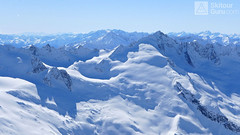
Ski tours around Hut Essener-Rostocker Hütte
-
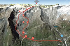
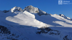
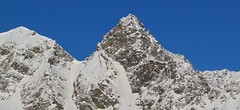
Mittlere Malmhalmspitze 3364 m
Essener-Rostocker Hütte Venedigergruppe - Hohe Tauern Austria
- Length of ascent km
- ascent1165 m
- duration6-8 h
- Fitness difficulty ♦♦♦◊
- Technical difficulty ♦♦♦◊
Mittlere Malmhalmspitze is a Skitour known for its excellent downhill ride, which can be extended to the Virgental Valley. A shorter yet physically demanding tour. From the Essener-Rostocker Hütte first south towards Maurer Alm and then west to the Nördlliches Malhamkees glacier. Cross the slope "Böse Wand" to the top.

-

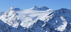
Westliche Simonyspitze 3488 m
Essener-Rostocker Hütte Venedigergruppe - Hohe Tauern Austria
- Length of ascent5 km
- ascent1400 m
- duration6,5-8,5 h
- Fitness difficulty ♦♦♦◊
- Technical difficulty ♦♦♦◊
Westliche Simonyspitze is a great alpine ski tour with a view of the Dreiherrnspitze. First, it rises to Reggentörl. Short downhill and follow the Umbalkees Glacier up. The ascent to the top is usually without skis. Downhill is great especially for firn.
-
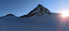
Grosser Geiger SW 3360 m
Essener-Rostocker Hütte Venedigergruppe - Hohe Tauern Austria
- Length of ascent7,5 km
- ascent1090 m
- duration5,5-7 h
- Fitness difficulty ♦♦♦◊
- Technical difficulty ♦♦♦◊
Favorite ski tour from Essener-Rostocker Hütte. Climbing the Grosser Geiger from the south leads along the Maurerkees glacier. At 2650 meters, the route turns north-westward and heads a rather steep slope towards the flat upper glacier. There is skidepo under the top pyramid. On the top of the undemanding terrain in crampons and ice axe. Follow the same route to hut.
-
Dreiherrnspitze 3499 m
Essener-Rostocker Hütte Venedigergruppe - Hohe Tauern Austria
- Length of ascent8,6 km
- ascent1430 m
- duration9-11 h
- Fitness difficulty ♦♦♦♦
- Technical difficulty ♦♦♦◊
The Dreiherrnspitze is a spectacular, complex and challenging glacier ski tour. Especially difficult is its length, glacial cracks and terrain break at the end. First, it is easy to climb glacier the Südl. Malhamkees to Regentörl saddle. After a short downhill northwards to the Umbalkees Glacier, the traverse between the cracks and then to the Althauskees. Relatively steep slope to difficult terrain break (depending on snow conditions). After overcoming it, there is only 200 high meters in easy terrain. Downhill same track as ascent.
-
Rostocker Eck 2749 m
Essener-Rostocker Hütte Venedigergruppe - Hohe Tauern Austria
- Length of ascent km
- ascent550 m
- duration h
- Fitness difficulty ♦♦◊◊
- Technical difficulty ♦♦◊◊
Rostocker Eck is a warm-up ski tour near the Essener-Rostocker Hütte. it is a tour, usually rising up the northern slope and descending the southern slope. Excellent lookout tower 550 m above the hut.
- Country
- Austria
- Montains
- Venedigergruppe - Hohe Tauern
- Open (winter)
- March - beginning May
- Beds
- 114
- Winterraum
- open, 16 beds
- Shortening of access (cableway, lift, taxi, snowcat...)
- no
- Luggage transport
- on the cableway from Maurertal, 30 min from p
- Card Pay
- yes
- Shower
- yes
- Wifi
- yes
- UTM / CH1903 x ("longitude" E/W)
- 33T 294797
- UTM / CH1903 y ("latitude" N/S)
- 5214815
- GPX access to hut (waipoints, track)
- Essener Rostocker Huette_access.gpx
- GPX access to hut (track only)
- ERHuette-access-TRACK.gpx
- Map
- Venedigergruppe, OEAV 1:25000, Nr. 36 Wege und Skitouren
- Guides
- Skitourenführer Hohe Tauern / Panico, deutsch Schitouren-Atlas ÖSTERREICH WEST / SchallVerlag, deutsch Hohe Tauern (Bergverlag Rother)
- Phone (hut)
- 0043/4877/5101
- Phone (valley)
- 0043/660/7678426
- Cell phone
- -
- Mobile Signal
- yes
- Web
- dav-essen.de
- essener.rostocker@gmx.at
- Owner of hut
- DAV Sektion Essen
- Essener Rostocker Hütte, 2208 m
- Reservation
- phone, e-mail
- Start Point
- Ströden - parking
- UTM / CH1903 x ("longitude" E/W)
- 33T 296308
- UTM / CH1903 y ("latitude" N/S)
- 5210503
- Altitude
- 1400 m
- Ascent (height difference)
- 820 m
- Time of Access
- 2-3 h
- Shortening lift
- no, only lugagge by cable car
- Avalanche danger
- lawine.at
- Weather
- Essener-Rostocker Hütte / meteoblue.com Dreiherrnspitze / mountain-forecast.com Ochsenbug / mountain-forecast.com Bergwetter Tirol 2 days / orf.at Essener-Rostocker Hütte / yr.no Ostalpen / alpenverein.at (de) Tirol / orf.at Austria / ZAMG.ac.at
- Snow report
- Dreiherrnspitze / mountain-forecast.com St. Jakob in Deferegtal /bergfex.at St. Jakob in Deferegtal / onthesnow.com
- Webcams
- Essener-Rostocker Hütte
- Region
- Virgental
- Public traffic
- Postbus ÖBB Railway
- Skiresort nearby
- St. Jakob im Defereggental Kals - Matrei in Osttirol
- Other links
- Austria Tourism
hut Essener-Rostocker Hütte - Reviews
There are no reviews in this section yet. Click the Add Review button to add first review.
Best ski tours in mountains Venedigergruppe - Hohe Tauern, Austria
-
Schlieferspitze 3289 m
Kürsinger Hütte Venedigergruppe - Hohe Tauern Austria
- Length of ascent7,5 km
- ascent1050 m
- duration5-6,5 h
- Fitness difficulty ♦♦♦◊
- Technical difficulty ♦♦♦◊
Relatively demanding glacier ski tour on 3289 m Schlieferspitze leads glacial terrain. To stay on Kürsinger Hut fits is Schlieferspitze ideal tour for the last day. After ascent to descent the eastern slopes and valleys Sulzbachtal the parking lot. When staying overnight at Postalm is actually the only option for the ascent.
-
Grossvenediger N (Kürsinger H.) 3666 m
Kürsinger Hütte Venedigergruppe - Hohe Tauern Austria
- Length of ascent8 km
- ascent1230 m
- duration6-7 h
- Fitness difficulty ♦♦◊◊
- Technical difficulty ♦♦♦◊
Grossvenediger is significant, pyramidal peak, the fourth highest mountain in Austria in in the centre of glaciated mountains in the mountain group Venedigergruppe in the Hohe Tauern. Ski tour from Kürsinger Hütte leads almost all the glaciers, over the saddle Venedigerscharte. In the finish is a short walk from the skidepot and with the crampons and axe comes with an easy ridge to the summit.
-

Grosser Geiger N 3360 m
Kürsinger Hütte Venedigergruppe - Hohe Tauern Austria
- Length of ascent5,5 km
- ascent1490 m
- duration6-7 h
- Fitness difficulty ♦♦♦◊
- Technical difficulty ♦♦♦◊
Grosser Geiger is a challenging skitour on the glacier terrain of the Alps part Venedigergruppe. It is available from Kürsinger Hütte on the north-facing slopes and from the Essener-Rostocker Hütte on the southern slopes. The most difficult part of the exit is to overcome the steep part on the main ridge.
Best ski tours in Austria by skitour.guru
-
Finailspitze North (from Hochjoch Hospiz) 3514 m
Hochjoch Hospiz Ötztal Alps / Alpi Venoste Austria
- Length of ascent7 km
- ascent1390 m
- duration5,5-7 h
- Fitness difficulty ♦♦♦◊
- Technical difficulty ♦♦♦◊
The tour to Fineilspitze begins with a short descent from the Hochjoch Hospiz hut into the valley of the Rofenache stream. Cross the stream and ascend on the right-hand side above the gorge. After the valley widens, continue left up over a moraine onto the glacier. On the glacier, head right of the ridge to a point at 3447 m. Leave the skis there and continue without them, using crampons, over exposed terrain along the ridge to the summit. Descent follows the ascent route.
-
Zuckerhütl (from Eisjochferner - cable car) 3505 m
Stubai - Mutterbergalm (cable car) Stubai Alps Austria
- Length of ascent5 km
- ascent960 m
- duration5,5-6,5 h
- Fitness difficulty ♦♦◊◊
- Technical difficulty ♦♦♦◊
Zuckerhütl je nejvyšší hora Stubaiských Alp. Leží nedaleko ledovcového skiresortu Stubaier Gletscherbahn. Pokud vyjedete lanovkou na nejvyšší bod střediska Eisjochferner a zatočíte po vysednutí ze sedačkové lanovky doleva k restauraci Jochdohle, začnete túru sjezdem z výšky 3150 m po ledovci Gaiskarferner. Ze dna karu (2751 m) do sedla Pfaffenjoch a po plochém ledovci pod vrcholovou pyramidu. Odtud bez lyží, v mačkách a s cepínem na vrchol. Při sjezdu po ledovci Sulzenauferner dávejte velký pozor na četné ledovcové trhliny.
-
Silvrettahorn 3244 m
Wiesbadener Hütte Silvretta Austria
- Length of ascent5 km
- ascent960 m
- duration5-6,5 h
- Fitness difficulty ♦♦♦◊
- Technical difficulty ♦♦♦◊
The ascent to the Silvrettahorn is one of the most popular excursion destinations of the Wiesbadener Hütte. After crossing the Ochsentaler Glacier, the ascent line turns right. The climb continues in the direction of Egghornlücke, but still turns right under the saddle. From the ski depot without skis over Westgrat to the summit.