
 Česky
Česky Deutsch


Peak
- Country
- Switzerland
- Montains
- Silvretta
- Tags
- Austria Jamtalhütte Silvretta Tirol
- Hut
- Tuoi Chamonna / Tuoihütte
- UTM / CH1903 x ("longitude" E/W)
- 807206
- UTM / CH1903 y ("latitude" N/S)
- 192112
Start point
- Start Point
- Tuoi Chamonna / Tuoihütte
- Altitude
- 2251 m
- UTM / CH1903 x ("longitude" E/W)
- 805492
- UTM / CH1903 y ("latitude" N/S)
- 190129
- village, valley
- Tuoital
Conditions
- Avalanche danger
- slf.ch - Institut für Schnee- und Lawinenforschung
- Weather
- Tuoihütte / meteoblue.com Alpenverein.at - Ostalpen Bergwetter Tirol 2 days Piz Tasna 3179m / mountain-forecast.com Paraid Naira 3015m / mountain-forecast.com Fluchthorn 3399m / mountain-forecast.com ORF.at ZAMG Austria
- Snow report
- Scuol / snow-forecast.com Scuol / onthesnow.com Scuol / bergfex.ch
- Webcams
- Chamanna Tuoi Scuol - Motta Naluns
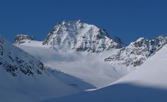
Ski tour map on Vordere/ Hintere Jamspitze SW


 bivakovací nouzová chata
  cepín a mačky potřeba
 exponovaný, obtížný terén
 horská chata
 hôtel, penzion
 lanovka, vlek
 lavinové nebezpečí, svah > 30°
 ledovcové trhliny
 lehká túra
 mimořádně obtížná túra
 mírně obtížná túra
 obtížná túra
 parkoviště
 přístup k chatě
 restaurace
 sedlo
sedlo sjezd
sjezd skidepo
 vrchol
 výstup
 začátek ledovce
- bivouac, winter room
- crampons & ice axe necessary
- exposed, difficulty terrain
- mountain hut, refuge
- hotel, pension
- cableway, skilift
- avalanche danger, slope > 30°
- glacier cracks
- little difficult tour
- extremely difficult tour
- rather difficult tour
- difficult tour
- parking
- hut acces
- restaurant
- col, pass, saddle
- descent
- skidepot
- peak, summit
- ascent
- glacier beginning
- biwak, winterraum
- steigeisen & pickel erforderlich
- ausgesetzt, schwierige gelände
- berghütte
- hotel, pension
- seilbahn, skilift
- lawinengefahr, hangneigung > 30°
- gletscherspalten
- wenig schwierige tour
- äusserst schwierige tour
- ziemlich schwierige tour
- schwierige tour
- parkplatz
- zugang zur hütte
- restaurant
- sattel, joch, pass
- abfahrt
- skidepot
- gipfel
- aufsieg
- gletscher anfang
- bivacco, locale invernale
- ramponi & piccozza necessari
- esposto, terreno difficolt?
- rifugio, capanna
- alberghi, pensione
- funivia, seggiovia
- pericolo di valanghe, pendenza > 30°
- crepe glacier
- tour piccolo difficile
- tour estremamente difficile
- tour piuttosto difficile
- escursioni difficili
- parcheggio
- accesso capanna
- ristorante
- col, sella, passo, forcella
- discesa
- sci deposito
- picco, vertice, piz
- salita
- inizio ghiacciaio
- bivouac, local d'hiver
- crampons & piolet nécessaire
- exposée, difficulté du terrain
- cabane de montagne, refuge
- hôtel, pension
- téléphérique, téléski
- danger d'avalanche, pente > 30°
- crevasse du glacier
- peu difficile tour
- extr?mement difficile tournée
- assez difficile tour
- difficile tournée
- parking
- acces cabane
- restaurant
- col, selle
- descente
- skis dépôt
- pic, sommet
- ascension
- début glacier
- < 20°
- 20° - 25°
- 25° - 30°
- 30° - 35°
- 35° - 40°
- > 40°
Current weather conditions in the tour area
Planning of ski tour
- Fitness difficulty
-
- ♦♦◊◊
- Technical difficulty
-
- ♦♦◊◊
- best time for this tour
- all winter
- Glacier
- Yes
- Map
- Silvrettagruppe, OEAV 1:25000, Nr. 26 Tarasp, Landeskarte der Schweiz mit Skitouren 1:50000, Nr. 249 S
- Guides
- Skitourenführer Tirol / Alpinverlag, deusch Ötztal – Silvretta / Bergverlag Rother, deusch SCHITOUREN-ATLAS ÖSTERREICH WEST / Schall Verlag, deusch Graubünden Süd Skitouren / SAC-CAS, deutsch, french Engadin / Bergverlag Rother, deusch
About Ski tour
- Time difficulty
- Ascent (height difference)
- 910 m
- Lenght of ascent
- km
- Descent (height difference)
- 910 m
- Total time of the tour
- 3-4 h
- Elevation Range
- 2250 - 3155 m
- Principal Aspect
- N, E S-south, N-north, W-west, E-east
Download
- KML (with POI)
- Jamspitzen_3156-76m_skitour.kml for viewing in the Google Earth 3D map application, which you can install on your PC
Current avalanche potential on tour - Vordere/ Hintere Jamspitze SW

tour Vordere/ Hintere Jamspitze SW - Reviews
There are no reviews in this section yet. Click the Add Review button to add first review.
Ski tours around Hut Tuoi Chamonna / Tuoihütte, in mountains Silvretta, Switzerland

Best ski tours in Silvretta by skitour.guru
-
Vordere Jamspitze from Jamtalhütte 3154 m
Jamtalhütte Silvretta Austria
- Length of ascent6 km
- ascent1050 m
- duration4,5-6 h
- Fitness difficulty ♦♦◊◊
- Technical difficulty ♦♦♦◊
Jamspitze is a very popular skitour from the Jamtalhütte. It is a light ski tour along the Jamtalferner glacier to the Jamspitze saddle. The saddle is followed by a sharp slope without skis in crampons.

-

Nördliche Augstenspitze Circuit 3228 m
Jamtalhütte Silvretta Austria
- Length of ascent10 km
- ascent1450 m
- duration6-8 h
- Fitness difficulty ♦♦♦◊
- Technical difficulty ♦♦♦◊
Nördliche Augstenspitze is a comprehensive and varied skitour from the Jamtalhütte. First goes to the saddle through the Chalausferner glacier to Fuorcla chalaus saddle, usually in crampons. Short descent to the Oberer Augstenferner Glacier. At the end in crampons and with ice ax to the top. A possible alternative is to extend the tour through Urezzasjoch.
-

Piz Tasna from Heidelberger Hütte 3179 m
Heidelberger Hütte Silvretta Austria
- Length of ascent7 km
- ascent980 m
- duration6,5-8 h
- Fitness difficulty ♦♦♦◊
- Technical difficulty ♦♦♦◊
Piz Tasna je oblíbený vrchol oblasti kolem Heidelberger Hütte. Cesta pod horu údolím Fimbertal je velmi dlouhá. Na vrcholovém hřebeni pozor, jde o exponovaný terén. Obtížnost v závěru hodně záleží na podmínkách.