
 Česky
Česky Deutsch


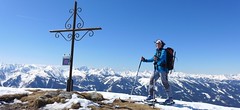


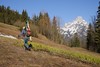


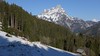

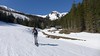
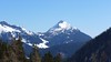

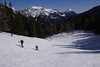
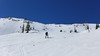

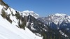
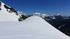


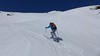

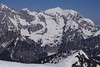


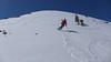

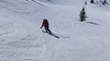
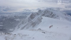
Blaseneck is a relatively easy ski tour. Forest paths lead to Ploderalm from parking lots at Johnsbachlift or Ebnerklamm. Over the Ploderalm and briefly through the forest to the top. View from the top of the Gesäuse and the Paltental. At descent follows the ascent.
Peak
- Country
- Austria
- Montains
- Gesäuse
- Tags
- Austria Gesäuse Johnsbach Steiermark
- Hut
- Johnsbach - Kölblwirt
- UTM / CH1903 x ("longitude" E/W)
- 33 T 471454
- UTM / CH1903 y ("latitude" N/S)
- 5260602
Start point
- Start Point
- Johnsbach Ebnerklamm / Johnsbach Lift
- Altitude
- 888 m
- UTM / CH1903 x ("longitude" E/W)
- 33 T 473166
- UTM / CH1903 y ("latitude" N/S)
- 5263770
- village, valley
- Johnsbachtal
- cableway / lift
- no, by car
Conditions
- Avalanche danger
- lawine.at
- Weather
- Johnsbach /Meteoblue.com Lugauer / Meteoblue.com Hochtor / Mountain-forecast.com Steirmark / ORF Steirmark / ZAMG
- Snow report
- Dorflift Johnsbach
- Webcams
- Dorflift Johnsbach Kölblalm Gscheidegg
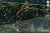
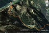
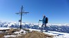
Ski tour map on Blaseneck


 bivakovací nouzová chata
  cepín a mačky potřeba
 exponovaný, obtížný terén
 horská chata
 hôtel, penzion
 lanovka, vlek
 lavinové nebezpečí, svah > 30°
 ledovcové trhliny
 lehká túra
 mimořádně obtížná túra
 mírně obtížná túra
 obtížná túra
 parkoviště
 přístup k chatě
 restaurace
 sedlo
sedlo sjezd
sjezd skidepo
 vrchol
 výstup
 začátek ledovce
- bivouac, winter room
- crampons & ice axe necessary
- exposed, difficulty terrain
- mountain hut, refuge
- hotel, pension
- cableway, skilift
- avalanche danger, slope > 30°
- glacier cracks
- little difficult tour
- extremely difficult tour
- rather difficult tour
- difficult tour
- parking
- hut acces
- restaurant
- col, pass, saddle
- descent
- skidepot
- peak, summit
- ascent
- glacier beginning
- biwak, winterraum
- steigeisen & pickel erforderlich
- ausgesetzt, schwierige gelände
- berghütte
- hotel, pension
- seilbahn, skilift
- lawinengefahr, hangneigung > 30°
- gletscherspalten
- wenig schwierige tour
- äusserst schwierige tour
- ziemlich schwierige tour
- schwierige tour
- parkplatz
- zugang zur hütte
- restaurant
- sattel, joch, pass
- abfahrt
- skidepot
- gipfel
- aufsieg
- gletscher anfang
- bivacco, locale invernale
- ramponi & piccozza necessari
- esposto, terreno difficolt?
- rifugio, capanna
- alberghi, pensione
- funivia, seggiovia
- pericolo di valanghe, pendenza > 30°
- crepe glacier
- tour piccolo difficile
- tour estremamente difficile
- tour piuttosto difficile
- escursioni difficili
- parcheggio
- accesso capanna
- ristorante
- col, sella, passo, forcella
- discesa
- sci deposito
- picco, vertice, piz
- salita
- inizio ghiacciaio
- bivouac, local d'hiver
- crampons & piolet nécessaire
- exposée, difficulté du terrain
- cabane de montagne, refuge
- hôtel, pension
- téléphérique, téléski
- danger d'avalanche, pente > 30°
- crevasse du glacier
- peu difficile tour
- extr?mement difficile tournée
- assez difficile tour
- difficile tournée
- parking
- acces cabane
- restaurant
- col, selle
- descente
- skis dépôt
- pic, sommet
- ascension
- début glacier
- < 20°
- 20° - 25°
- 25° - 30°
- 30° - 35°
- 35° - 40°
- > 40°
Current weather conditions in the tour area
Planning of ski tour
- Fitness difficulty
-
- ♦♦◊◊
- Technical difficulty
-
- ♦♦◊◊
- best time for this tour
- Januar-April
- Glacier
- No
- Map
- Gesäuse, OEAV 1:25000, Nr. 16
- Guides
- Skitourenführer Österreich - Band1 / Alpinverlag, deutsch SCHITOUREN-ATLAS ÖSTERREICH OST / Schall-Verlag. deutsch Obersteiermark / Bergverlag Rother, deutsch
About Ski tour
- Time difficulty
- Ascent (height difference)
- 1090 m
- Lenght of ascent
- 7 km
- Descent (height difference)
- 1090 m
- Total Lenght of tour
- 14 km
- Total time of the tour
- 4-5 h
- Elevation Range
- 880 - 1969 m
- Principal Aspect
- N, NE S-south, N-north, W-west, E-east
Download
- GPX (track only)
- Blaseneck-TRACK.gpx best for display on a detailed topographical map (mapy.cz) or in apps for smartphones (Locus, Garmin Connect, etc.)
- GPX (waipoints, track)
- Blaseneck TOUR SkitourGuru.gpx great for uploading in GPS device
- KML (with POI)
- Blaseneck1958mLift_skitour.kml for viewing in the Google Earth 3D map application, which you can install on your PC
Video of tour on Blaseneck
Current avalanche potential on tour - Blaseneck

tour Blaseneck - Reviews
There are no reviews in this section yet. Click the Add Review button to add first review.
Ski tours around Hut Johnsbach - Kölblwirt, in mountains Gesäuse, Austria
-

Lugauer 2206 m
Johnsbach - Kölblwirt Gesäuse Austria
- Length of ascent11 km
- ascent1680 m
- duration6,5-8,5 h
- Fitness difficulty ♦♦♦♦
- Technical difficulty ♦♦♦◊
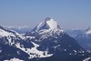
Lugauer is a distinctive mountain rightfully called Styrian Matterhorn. Ascent is long, due to elevation and length, so it is good fitness advantage. Excellent experience promises a conclusion ascent over the forest. Finish on the ridge in the crampons.

-
Gsuchmauer 2116 m
Johnsbach - Kölblwirt Gesäuse Austria
- Length of ascent6,5 km
- ascent1150 m
- duration4-6 h
- Fitness difficulty ♦♦◊◊
- Technical difficulty ♦♦◊◊
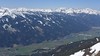
Gsuchmauer is a famous classic ski tour from the Johnsbach Valley. First on a forest road and on alpine pasture turn left in S direction to rock. After a clear line from the valley to the ridge and further right upwards. Beautiful view of Lugauer, Hochtor and Blaseneck. At the descent, follow the ascent route.
-

Festkogel 2269 m
Johnsbach - Kölblwirt Gesäuse Austria
- Length of ascent5,5 km
- ascent1430 m
- duration6-8 h
- Fitness difficulty ♦♦♦◊
- Technical difficulty ♦♦♦◊
Festkogel is a very attractive ski tour between the rocks with a breathtaking view of the whole Gesäuse and the Enns valley. From the parking (of the Hesshütte), nearby the restaurant and Hotel Kölblwirt towards the waterfall along the trail. Continue through a steep narrow rock ditch towards the tower Schneekarturm. Around the tower until the last part of the climb. By frequent crossing of steep slopes, the Festkogel is recommended a ski trip in stable conditions.