
 Česky
Česky Deutsch


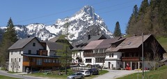

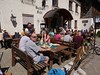
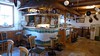
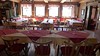


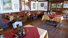


Likeable mountain hotel at the end of the village Johnsbach, renowned for excellent cuisine. Suitable accommodation for hikes to Lugauer, Gsuchmaer, Festkogel, Blaskogel etc.
Tours starting from hut
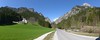
Ski tours around Hut Johnsbach - Kölblwirt
-
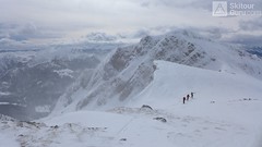
Gsuchmauer 2116 m
Johnsbach - Kölblwirt Gesäuse Austria
- Length of ascent6,5 km
- ascent1150 m
- duration4-6 h
- Fitness difficulty ♦♦◊◊
- Technical difficulty ♦♦◊◊
Gsuchmauer is a famous classic ski tour from the Johnsbach Valley. First on a forest road and on alpine pasture turn left in S direction to rock. After a clear line from the valley to the ridge and further right upwards. Beautiful view of Lugauer, Hochtor and Blaseneck. At the descent, follow the ascent route.

-
Blaseneck 1969 m
Johnsbach - Kölblwirt Gesäuse Austria
- Length of ascent7 km
- ascent1090 m
- duration4-5 h
- Fitness difficulty ♦♦◊◊
- Technical difficulty ♦♦◊◊
Blaseneck is a relatively easy ski tour. Forest paths lead to Ploderalm from parking lots at Johnsbachlift or Ebnerklamm. Over the Ploderalm and briefly through the forest to the top. View from the top of the Gesäuse and the Paltental. At descent follows the ascent.
-

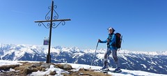
Festkogel 2269 m
Johnsbach - Kölblwirt Gesäuse Austria
- Length of ascent5,5 km
- ascent1430 m
- duration6-8 h
- Fitness difficulty ♦♦♦◊
- Technical difficulty ♦♦♦◊
Festkogel is a very attractive ski tour between the rocks with a breathtaking view of the whole Gesäuse and the Enns valley. From the parking (of the Hesshütte), nearby the restaurant and Hotel Kölblwirt towards the waterfall along the trail. Continue through a steep narrow rock ditch towards the tower Schneekarturm. Around the tower until the last part of the climb. By frequent crossing of steep slopes, the Festkogel is recommended a ski trip in stable conditions.
-

Lugauer 2206 m
Johnsbach - Kölblwirt Gesäuse Austria
- Length of ascent11 km
- ascent1680 m
- duration6,5-8,5 h
- Fitness difficulty ♦♦♦♦
- Technical difficulty ♦♦♦◊
Lugauer is a distinctive mountain rightfully called Styrian Matterhorn. Ascent is long, due to elevation and length, so it is good fitness advantage. Excellent experience promises a conclusion ascent over the forest. Finish on the ridge in the crampons.
- Country
- Austria
- Montains
- Gesäuse
- Open (winter)
- all winter
- Beds
- 40
- Winterraum
- 0
- Shortening of access (cableway, lift, taxi, snowcat...)
- accessible by car
- UTM / CH1903 x ("longitude" E/W)
- 33 T 470951
- UTM / CH1903 y ("latitude" N/S)
- 5264307
- Map
- Gesäuse, OEAV 1:25000, Nr. 16
- Guides
- Skitourenführer Österreich - Band1 / Alpinverlag, deutsch SCHITOUREN-ATLAS ÖSTERREICH OST / Schall-Verlag. deutsch Obersteiermark / Bergverlag Rother, deutsch
- Phone (hut)
- 0043 3611 216
- Phone (valley)
- -
- Cell phone
- -
- Web
- koelblwirt.at
- koelblwirt@aon.at
- Owner of hut
- Familie Wolf
- Avalanche danger
- lawine.at
- Weather
- Johnsbach /Meteoblue.com Lugauer / Meteoblue.com Hochtor / Mountain-forecast.com Steirmark / ORF Steirmark / ZAMG
- Snow report
- Dorflift Johnsbach
- Webcams
- Dorflift Johnsbach Kölblalm Gscheidegg
- Region
- Johnsbach Gesäuse NP
- Public traffic
- ÖBB Railway Postbus
hut Johnsbach - Kölblwirt - Reviews
There are no reviews in this section yet. Click the Add Review button to add first review.
Best ski tours in Austria by skitour.guru
-

Hochstein 2827 m
Innervillgraten Villgratner Berge - Deferegger Alpen Austria
- Length of ascent6,5 km
- ascent1150 m
- duration4-6 h
- Fitness difficulty ♦♦♦◊
- Technical difficulty ♦♦◊◊
Skialpová túra na Hochstein je členitá a zajímavá. Za almem Kamelisenalm se stoupá mírným táhlým západním svahem do sedla Öwelenke. Krátký sjezd na pásech a hned doleva traverzem směrem k jezeru (nesjíždět až dolů k potoku). Nejprudší výstup túry je z kotliny nad jezerem. Závěr výstupu na vrchol vede táhlým mírným svahem. Sjezd po trse výstupu. Alternativou je za dobrých podmínek přelezení hřebínku z posledního sedla do sektoru trasy na Rotes Kinkele a po dosažení vrcholu sjíždet trasou z Rotes Kinkele, která je sjezdařsky zajímavější.
-

Östliche Seespitze 3416 m
Franz Senn Hütte Stubai Alps Austria
- Length of ascent6,5 km
- ascent1270 m
- duration6-8 h
- Fitness difficulty ♦♦♦◊
- Technical difficulty ♦♦♦◊
Östliche Seespitze (Franz Senn Hütte, Stubaier Alpen) is a glacier tour with a steep passage (30-35°). At the end without skiing along the ridge to the summit.
-

Weisskugel East, from Hochjoch Hospiz 3739 m
Hochjoch Hospiz Ötztal Alps / Alpi Venoste Austria
- Length of ascent11 km
- ascent1550 m
- duration7-10 h
- Fitness difficulty ♦♦♦♦
- Technical difficulty ♦♦♦◊
Skialpinistická túra na Weisskugel je obtížná především svou délkou. Začátek túry se liší podle sněhové situace. Když je málo sněhu, jde se po rampě, víceméně po vrstevnici k ledovci Hintereisferner. Po ledovci mírně nahoru západním směrem. Prudký je až výšvih do sedla Hintereisjoch, odkud se stoupá doprava, severním směrem k vrcholu. Poslední desítky metrů vedou exponovaným terénem, hodně záleží na množství sněhu.