
 Česky
Česky Deutsch


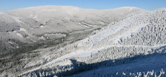
V okolí Železné Rudy, kterému dominují Špičák a Pancíř je několik značených skialpových tras. Z nedalekých prášil vede trasa na vrchol Poledníku. Všechny trasy jsou ve stylu kondičního fitnesss skitouringu. Kousek za hranicemi jsou tři trasy v masivu Velkého Javoru - Arberlandu. Od zastávky vlaku Železná Ruda - Špičák je to kousek do skicentra Špičák.
Tours starting from hut
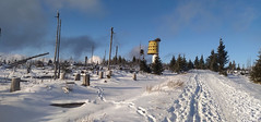
Ski tours around Hut Železná Ruda - Prášily
-

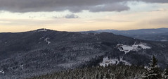
Špičák - Čertovo jezero, okruh 1202 m
Železná Ruda - Prášily Bohemian Forest Czech
- Length of ascent5 km
- ascent400 m
- duration1,5-2 h
- Fitness difficulty ♦◊◊◊
- Technical difficulty ♦◊◊◊
Kondiční túra kolem Špičáku. Vystoupat na vrchol k rozhledně se dá buď přes Špičácké sedlo nebo z druhé strany přes Čertovo jezero. Optimální je výstup na Špičák a po sjezdovce dolů. Následně totéž z druhé strany.

-
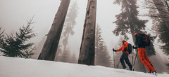
Poledník 1315 m
Železná Ruda - Prášily Bohemian Forest Czech
- Length of ascent km
- ascent m
- duration h
- Fitness difficulty ♦◊◊◊
- Technical difficulty ♦◊◊◊
Jednoduchá túra pro začátečníky vystupuje na Poledník po běžkařské trase. Sjezd vede přes Prášilské jezero. Dokonalá ukázka řádění orkánu Kyrill na hřebenu Šumavy.
-
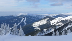
Pancíř z Javorné, okruh 1214 m
Železná Ruda - Prášily Bohemian Forest Czech
- Length of ascent7 km
- ascent575 m
- duration3-4 h
- Fitness difficulty ♦◊◊◊
- Technical difficulty ♦◊◊◊
Jednoduchá kondiční túra po mírných svazích pro úplné začátečníky. Okruh začíná a končí ve skiareálu Javorná.
- Country
- Czech
- Montains
- Bohemian Forest
- Open (winter)
- Beds
- 0
- Winterraum
- Shortening of access (cableway, lift, taxi, snowcat...)
- UTM / CH1903 x ("longitude" E/W)
- 33U 370348
- UTM / CH1903 y ("latitude" N/S)
- 5447342
- Map
- Šumava - Pláně, 1:25000, Nr. 66, Geodézie On-Line Šumava - Železnorudsko, 1:25000, Nr. 93, Geodézie On-Line
- Guides
- Skitour.Guru
- Phone (hut)
- -
- Phone (valley)
- -
- Cell phone
- -
- Web
- -
- -
- Owner of hut
- -
- Weather
- Grosser Arber, mountain-forecast.com Špičák, snow-forecast.com Špičák, wetteronline.de Špičák, ventusky.com Poledník, ventusky.com Poledník, meteoblue.com Prášily, ventusky.cz Prášily, meteoblue.com Železná Ruda, ventusky.cz Železná Ruda, meteoblue.com Předpovědní model Aladin Komplexní meteoservis Czech Republic
- Snow report
- Špičák - Železná Ruda, snow-forecast.com Špičák - Železná Ruda, snow.cz Špičák - Železná Ruda, bergfex.com
- Webcams
- Špičák skiresort 4x Pancíř webcam Prášily Šumava webcams
hut Železná Ruda - Prášily - Reviews
There are no reviews in this section yet. Click the Add Review button to add first review.
Best ski tours in mountains Bohemian Forest, Czech
-

Třístoličník - Plechý 1378 m
Trojmezí - Šumava Bohemian Forest Czech
- Length of ascent10 km
- ascent840 m
- duration5,5-7 h
- Fitness difficulty ♦♦◊◊
- Technical difficulty ♦◊◊◊
The ski tour to the highest part of the Šumava ridge leads over three important peaks. Hochstein 1333 m on the German side, Třístoličník 1302 m (Dreisesselberg) and finally Plechý (Plöckenstein), the highest point in the Czech part of Šumava. From above there is a view of the Plešné jezero lake, which separates the Jezerní stěna wall from the ridge. The route mainly leads along forest roads. The marked path along the ridge leads through the intersection of three borders - the Czech Republic, Germany (Bavaria) and Austria (Upper Austria). Refreshments are available in the Hut Berggasthof Dreisessel under Třístolicník. The ski tour can be included in the category of fitness ski tours and does not expect any downhill experiences. It is an ideal train ride from Nová Pec (the destination point) to Nové Údolí station, where this ski tour begins.
-
Smrčina - Hochficht 1333 m
Trojmezí - Šumava Bohemian Forest Czech
- Length of ascent13 km
- ascent840 m
- duration5-6,5 h
- Fitness difficulty ♦♦◊◊
- Technical difficulty ♦◊◊◊
On the top of Smrčina-Hpochficht, the highest point of the Austrian ski area Hochficht is located, from the czech side you must visit Nová Pec with ski and skins. A circuit through the Šumava forestes is offered. As Plechý is Smrčina also an ideal area for fitness ski tours.
Best ski tours in Czech by skitour.guru
-

Vozka 1377 m
Chata Jiřího na Šeráku Jeseniky Czech
- Length of ascent7 km
- ascent555 m
- duration3-5 h
- Fitness difficulty ♦◊◊◊
- Technical difficulty ♦◊◊◊
Snadná a panoramatická lyžařská túra na Vozku. Začíná na Červenohorském sedle a přes Vřesovou studánku a Červenou horu vede po křebenu hrubého Jeseníku k odbočce na Vozku. Odtud sjezd do údolí k lyžařskému areálu Kouty.
-
Labský důl - circuit 1358 m
Brádlerovy boudy Giant Mountains Czech
- Length of ascent6,5 km
- ascent585 m
- duration3,5-5 h
- Fitness difficulty ♦◊◊◊
- Technical difficulty ♦◊◊◊
A round trip around the huts above Špindlerův Mlýn. The route begins with a descent from Bradlerovy boudy and goes into the Labsjý důl valley. The ascent to Labská bouda and about 1 km behind the hut begins the descent to Martinova bouda and then to the Brádlerovy boudy. Possible to combine with the ascent to Vysoké kolo. Another variant is the ridge route from Labská bouda via Vysoké kolo - see the Krkonoše-haute route day1 ski tour.
-
Sestupová, trasa"D", Dolní Morava 1232 m
Slaměnka - Dolní Morava Jeseniky Czech
- Length of ascent6 km
- ascent540 m
- duration2,5-3,5 h
- Fitness difficulty ♦◊◊◊
- Technical difficulty ♦◊◊◊
Trasy pro fitness skitouring nebo skitouring pro začátečníky na Dolní Moravě jsou vyznačeny, vedou po lesních přístupových cestách v blízkosti sjezdovek, část souběžně s běžeckými trasami a značenými turistickými chodníky. Na těchto trasách nepotřebujete lavinovou výbavu. Potřebné vybavení si můžete půjčit ve Skitourcentum u parkoviště na Točně nebo v půjčovně střediska DM naproti hotelu Vista. Skialpová trasa "D" slouží hlavně pro jízdu dolů z vrcholu Slamník. Dá se využít i pro výstup, hlavně ve středu a v pátek, a to i do pozdního večera při čelovce. Vede od Skitourcentra podél silnice k hotelu Vista, dále pak cestou k bývalému lomu. Od něj vpravo lesní cestou až k horní stanici lanovky U Slona – Vyhlídka. Dále pak stejně jako trasou A. Přes rozcestí u Chlumu kolem Slaměnky na Slamník. Na této trase dbejte zvýšené opatrnosti při dvojitém přecházení sjezdových tratí skiareálu, hlavně při jízdě dolů, kdy může být na sjezdových tratích pracující rolba. Všechny trasy na DM se dají zakončit u horské chaty Slaměnka pod vrcholem Slamníku. Sjezd do údolí je po sjezdovkách střediska, které jsou po 16 h. zavřené. V případě večerního sjezdu pozor na nebezpečí ocelového lana, na kterém je zavěšena rolba upravující svah. Lano představuje smrtelné nebezpečí!