
 Česky
Česky Deutsch


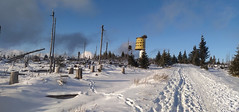


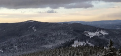
Jednoduchá túra pro začátečníky vystupuje na Poledník po běžkařské trase. Sjezd vede přes Prášilské jezero. Dokonalá ukázka řádění orkánu Kyrill na hřebenu Šumavy.
Peak
- Country
- Czech
- Montains
- Bohemian Forest
- Tags
- české hory Poledník Prášily skialpujdoma ski touring with children Špičák Šumava Železná Ruda
- Hut
- Železná Ruda - Prášily
- UTM / CH1903 x ("longitude" E/W)
- 33U 382779
- UTM / CH1903 y ("latitude" N/S)
- 5435827
Start point
- Start Point
- Prášily - parking
- Altitude
- 900 m
- UTM / CH1903 x ("longitude" E/W)
- 33U 381655
- UTM / CH1903 y ("latitude" N/S)
- 5440365
Conditions
- Weather
- Grosser Arber, mountain-forecast.com Špičák, snow-forecast.com Špičák, wetteronline.de Špičák, ventusky.com Poledník, ventusky.com Poledník, meteoblue.com Prášily, ventusky.cz Prášily, meteoblue.com Železná Ruda, ventusky.cz Železná Ruda, meteoblue.com Předpovědní model Aladin Komplexní meteoservis Czech Republic
- Snow report
- Špičák - Železná Ruda, snow-forecast.com Špičák - Železná Ruda, snow.cz Špičák - Železná Ruda, bergfex.com
- Webcams
- Špičák skiresort 4x Pancíř webcam Prášily Šumava webcams
Ski tour map on Poledník


 bivakovací nouzová chata
  cepín a mačky potřeba
 exponovaný, obtížný terén
 horská chata
 hôtel, penzion
 lanovka, vlek
 lavinové nebezpečí, svah > 30°
 ledovcové trhliny
 lehká túra
 mimořádně obtížná túra
 mírně obtížná túra
 obtížná túra
 parkoviště
 přístup k chatě
 restaurace
 sedlo
sedlo sjezd
sjezd skidepo
 vrchol
 výstup
 začátek ledovce
- bivouac, winter room
- crampons & ice axe necessary
- exposed, difficulty terrain
- mountain hut, refuge
- hotel, pension
- cableway, skilift
- avalanche danger, slope > 30°
- glacier cracks
- little difficult tour
- extremely difficult tour
- rather difficult tour
- difficult tour
- parking
- hut acces
- restaurant
- col, pass, saddle
- descent
- skidepot
- peak, summit
- ascent
- glacier beginning
- biwak, winterraum
- steigeisen & pickel erforderlich
- ausgesetzt, schwierige gelände
- berghütte
- hotel, pension
- seilbahn, skilift
- lawinengefahr, hangneigung > 30°
- gletscherspalten
- wenig schwierige tour
- äusserst schwierige tour
- ziemlich schwierige tour
- schwierige tour
- parkplatz
- zugang zur hütte
- restaurant
- sattel, joch, pass
- abfahrt
- skidepot
- gipfel
- aufsieg
- gletscher anfang
- bivacco, locale invernale
- ramponi & piccozza necessari
- esposto, terreno difficolt?
- rifugio, capanna
- alberghi, pensione
- funivia, seggiovia
- pericolo di valanghe, pendenza > 30°
- crepe glacier
- tour piccolo difficile
- tour estremamente difficile
- tour piuttosto difficile
- escursioni difficili
- parcheggio
- accesso capanna
- ristorante
- col, sella, passo, forcella
- discesa
- sci deposito
- picco, vertice, piz
- salita
- inizio ghiacciaio
- bivouac, local d'hiver
- crampons & piolet nécessaire
- exposée, difficulté du terrain
- cabane de montagne, refuge
- hôtel, pension
- téléphérique, téléski
- danger d'avalanche, pente > 30°
- crevasse du glacier
- peu difficile tour
- extr?mement difficile tournée
- assez difficile tour
- difficile tournée
- parking
- acces cabane
- restaurant
- col, selle
- descente
- skis dépôt
- pic, sommet
- ascension
- début glacier
- < 20°
- 20° - 25°
- 25° - 30°
- 30° - 35°
- 35° - 40°
- > 40°
Current weather conditions in the tour area
Planning of ski tour
- Fitness difficulty
-
- ♦◊◊◊
- Technical difficulty
-
- ♦◊◊◊
- best time for this tour
- all winter
- Glacier
- No
- Map
- Šumava - Pláně, 1:25000, Nr. 66, Geodézie On-Line Šumava - Železnorudsko, 1:25000, Nr. 93, Geodézie On-Line
- Guides
- Skitour.Guru
About Ski tour
- Time difficulty
- Ascent (height difference)
- - m
- Lenght of ascent
- km
- Descent (height difference)
- - m
- Total time of the tour
- h
- Elevation Range
- 900 - 1315 m
- Principal Aspect
- S-south, N-north, W-west, E-east
Download
- GPX (track only)
- Poledník_Prášily_TRACK.gpx best for display on a detailed topographical map (mapy.cz) or in apps for smartphones (Locus, Garmin Connect, etc.)
- GPX (waipoints, track)
- Polednik_Prasily_SKITOUR.gpx great for uploading in GPS device
- KML (with POI)
- Polednik_Prasily_SKITOUR.kml for viewing in the Google Earth 3D map application, which you can install on your PC
tour Poledník - Reviews
There are no reviews in this section yet. Click the Add Review button to add first review.
Ski tours around Hut Železná Ruda - Prášily, in mountains Bohemian Forest, Czech
-

Špičák - Čertovo jezero, okruh 1202 m
Železná Ruda - Prášily Bohemian Forest Czech
- Length of ascent5 km
- ascent400 m
- duration1,5-2 h
- Fitness difficulty ♦◊◊◊
- Technical difficulty ♦◊◊◊
Kondiční túra kolem Špičáku. Vystoupat na vrchol k rozhledně se dá buď přes Špičácké sedlo nebo z druhé strany přes Čertovo jezero. Optimální je výstup na Špičák a po sjezdovce dolů. Následně totéž z druhé strany.

-
Pancíř z Javorné, okruh 1214 m
Železná Ruda - Prášily Bohemian Forest Czech
- Length of ascent7 km
- ascent575 m
- duration3-4 h
- Fitness difficulty ♦◊◊◊
- Technical difficulty ♦◊◊◊
Jednoduchá kondiční túra po mírných svazích pro úplné začátečníky. Okruh začíná a končí ve skiareálu Javorná.
Best ski tours in Bohemian Forest by skitour.guru
-
Smrčina - Hochficht 1333 m
Trojmezí - Šumava Bohemian Forest Czech
- Length of ascent13 km
- ascent840 m
- duration5-6,5 h
- Fitness difficulty ♦♦◊◊
- Technical difficulty ♦◊◊◊
On the top of Smrčina-Hpochficht, the highest point of the Austrian ski area Hochficht is located, from the czech side you must visit Nová Pec with ski and skins. A circuit through the Šumava forestes is offered. As Plechý is Smrčina also an ideal area for fitness ski tours.
-

Třístoličník - Plechý 1378 m
Trojmezí - Šumava Bohemian Forest Czech
- Length of ascent10 km
- ascent840 m
- duration5,5-7 h
- Fitness difficulty ♦♦◊◊
- Technical difficulty ♦◊◊◊
The ski tour to the highest part of the Šumava ridge leads over three important peaks. Hochstein 1333 m on the German side, Třístoličník 1302 m (Dreisesselberg) and finally Plechý (Plöckenstein), the highest point in the Czech part of Šumava. From above there is a view of the Plešné jezero lake, which separates the Jezerní stěna wall from the ridge. The route mainly leads along forest roads. The marked path along the ridge leads through the intersection of three borders - the Czech Republic, Germany (Bavaria) and Austria (Upper Austria). Refreshments are available in the Hut Berggasthof Dreisessel under Třístolicník. The ski tour can be included in the category of fitness ski tours and does not expect any downhill experiences. It is an ideal train ride from Nová Pec (the destination point) to Nové Údolí station, where this ski tour begins.