
 Česky
Česky Deutsch


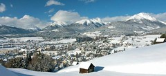
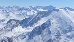
Tamsweg is the starting town for several ski tours in Lungau. The most famous route leads to Preber, directly above the town. In the immediate vicinity, there are routes to Zechnerkarspitze, as well as ski tour routes that are suitable and easier to Gstoder, Grosses Gurpitscheck, and Gumma.
Tours starting from hut
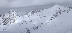
Ski tours around Hut Tamsweg - Lungau
- Country
- Austria
- Montains
- Niedere Tauern
- Open (winter)
- Beds
- 0
- Winterraum
- Shortening of access (cableway, lift, taxi, snowcat...)
- available by car
- Card Pay
- yes
- Shower
- yes
- Wifi
- yes
- UTM / CH1903 x ("longitude" E/W)
- 33T 409595
- UTM / CH1903 y ("latitude" N/S)
- 5220283
- Map
- Niedere Tauern, OEAV 1:25000, Nr. 45/II
- Guides
- SCHITOURENFÜHRER ÖSTERREICH Band I / Alpinverlag, DE SCHITOUREN-ATLAS ÖSTERREICH OST, Schall-Verlag
- Phone (hut)
- -
- Phone (valley)
- -
- Cell phone
- -
- Mobile Signal
- yes
- Web
- lungau.at
- info@tourismuslungau.at
- Owner of hut
- -
- Salzburger Lungau
- Online reservation
- booking.com
- Avalanche danger
- Lawine Salzburg
- Weather
- Tamsweg / Meteoblue.com Preber / Meteoblue.com Greim (Woelzer Tauern) 2474m / mountain-forecast.com Ostalpen / alpenverein.at Nieder Tauern Bergwetter 2 days / orf.at Salzburgland / orf.at Austria / ZAMG Skiwetter - Obertauern
- Snow report
- www.snow-forecast.com - Katschberg-Aineck www.snow-forecast.com - Obertauern
- Webcams
- Krakauschatten 1286m Speireck - St. Michael im Lungau Katschberg Obertauern Zederhaus - Autobahn
- Region
- Lungau
- Public traffic
- Postbus ÖBB Railway
- Skiresort nearby
- Lungau
- Other links
- Lungau.at - skitouren
hut Tamsweg - Lungau - Reviews
There are no reviews in this section yet. Click the Add Review button to add first review.
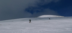
Best ski tours in mountains Niedere Tauern, Austria
-
Mosermandl 2677 m
Zederhaus - Kirchenwirt Niedere Tauern Austria
- Length of ascent8,5 km
- ascent1405 m
- duration6,5-7 h
- Fitness difficulty ♦♦♦◊
- Technical difficulty ♦♦♦◊
Gross Mosermandl je spolu s Weisseckem absolutním highlightem oblasti Zederhaustal v regionu Salzburger Lungau. Z parkoviště Wald se stoupá nejprve mírně údolím, pak po lesní cestě nahoru nad hranici lesa. Následují už svahy se sklonem 30 stupňů a větším. Nejobtížnější pasáž je v závěru výstupu, většinou bez lyží, v mačkách. Sjezd kopíruje trasu výstupu. Při dostatku času a sil je možné jít do Waldu přes kopec Schöpfling a místo cesty údolím si užít hezký sjezd.

-
Felskarspitze 2506 m
Zederhaus - Kirchenwirt Niedere Tauern Austria
- Length of ascent6,5 km
- ascent1195 m
- duration4-5,5 h
- Fitness difficulty ♦♦♦◊
- Technical difficulty ♦♦◊◊
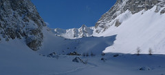
Skialpová túra na Felskarspitz je skvělá. Dolní polovina je v lese s možností hezkého sjezdu, horní čás je ve znamení ledovcového karu a mohutné jihovýchodní stěny Weissecku. Sjezd většinou závětrnou kotlinou, sklon tak akorát a místo pro všechny. Díky severní expozici často prašan. Pokud jsou dobré podmínky, vyplatí se z vrcholu pokračovat na Weisseck a prožít fantastický, dlouhý sjezd.
-
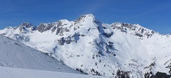
Weisseck 2711 m
Zederhaus - Kirchenwirt Niedere Tauern Austria
- Length of ascent7 km
- ascent1450 m
- duration5-7 h
- Fitness difficulty ♦♦♦◊
- Technical difficulty ♦♦♦◊
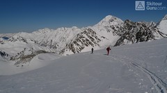
Ski tour to the impressive Weisseck. In good conditions, a spectacular Ödenkar boiler descent is offered. If we don't climb to the Weisseck, the beautiful Ferskarspitze is on the way. Through the forest you reach the valley "In hell" (In der Hölle) - on one side of the rock towers, on the other side of the wall of Weisseck. Enter the Ödenkar from the upper plateau with the summit cross and watch out for snow guards and a very steep start.
Best ski tours in Austria by skitour.guru
-
Grosses Degenhorn 2937 m
Innervillgraten Villgratner Berge - Deferegger Alpen Austria
- Length of ascent11 km
- ascent1470 m
- duration7,5-9,5 h
- Fitness difficulty ♦♦♦◊
- Technical difficulty ♦♦◊◊
Skialpová túra na Grosses Degenhorn míří na jeden z nejvyšších vrcholů pohoří Villgraten, a proto je z něj skvělý výhled. Nádherný firnový sjezd si musíte zasloužit dlouhým výstupem přes údolí Arntal. Díky své výšší poloze je možné túru podniknout i v květnu. V jarních podmínkách je nutné počítat s dlouhou chůzí bez lyží údolím Arntal.
-

Nockberge Trail Day 2 2336 m
Innerkrems - Mehrlhütte Nockberge Austria
- Length of ascent10,5 km
- ascent1210 m
- duration6-8 h
- Fitness difficulty ♦♦♦◊
- Technical difficulty ♦♦♦◊
2. etapa 4denního skialpového přechodu Nockberge Trail vede z Innerkremsu na Turracher Höhe a je ze všech nejnáročnější - jak délkou, převýšenm tak i technickou náročností. Oblé kopce alpského pohoří Nockberge mají jedinou nevýhodu - vítr z jejich svahů často odfoukne sníh a je ho místy nedostatek. Po bezproblémovém výstupu na Königstuhl a Karlnock následuje sjezd do sedla Stangnock a pak po širokém hřebenu nahoru na Gregerlnock. Následující sjezd poměrně prudkým svahem má lavinový potenciál - buďte pozorní, v případě špatných podmínek sjíždějte po hřebenu do míst, kde je svah mírnější. Po sjezdu na alm následuje orientačně zapeklitá fáze - držte se striktně linie v GPS. Za potokem začíná výstup na Winkler Alm. Cesta na sjezdovku nevede přes les (pozor na stopy). Až dorazíte k sjezdovce, musíte ještě vystoupat k lanovce Schafalmbahn (na dohled) a po sjezdovce č.1 na sedlo Turracher Höhe.
-
Hinterer Daunkopf (N, from Amberger H.) 3225 m
Amberger Hütte Stubai Alps Austria
- Length of ascent7 km
- ascent1100 m
- duration4-5,5 h
- Fitness difficulty ♦♦◊◊
- Technical difficulty ♦♦◊◊
Krásná túra členitým terénem po zajímavé hraně ledovce na vrchol Hinterer Daunkopf. Krásný výhled na sjezdovky střediska Stubaier Gletscher. Pozor na orientaci a hlavně stav ledovce. Sjezd po výstupové linii.