
 Česky
Česky Deutsch


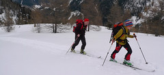
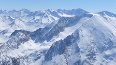
The Zederhaustal valley near the Lungau ski resort is an excellent starting point for many ski tours. Valuable skitours come mainly from the parking in Wald - Weisseck, Felskarspitze, Grosser Mosermandl ... After a tour, go to the Kirchenwirt for dinner - it cooks well and Peter Gruber will give you relevant ski touring tips for the next days.
Tours starting from hut
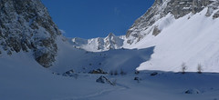
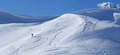
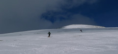
Ski tours around Hut Zederhaus - Kirchenwirt
-
Seeköpfl 2222 m
Zederhaus - Kirchenwirt Niedere Tauern Austria
- Length of ascent6 km
- ascent1000 m
- duration3-4,5 h
- Fitness difficulty ♦♦◊◊
- Technical difficulty ♦◊◊◊
Túra na vrchol Seeköpfl patří mezi ty nejlehčí a hodí se na dny s ne zrovna ideálním počasím. Po jednoduché trase po lesní cestěk hranici lesa, následně stoupání lesem a pak po širokém, otevřeném svahu na nevýrazný vrchol. Sjezd buď po trase výstupu nebo po severních svazích a cestách na parkoviště Wald. V případě této volby je nutno mezi parkovišti dojít pěšky nebo stopem.

-
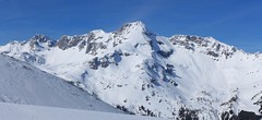
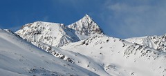
Weisseck 2711 m
Zederhaus - Kirchenwirt Niedere Tauern Austria
- Length of ascent7 km
- ascent1450 m
- duration5-7 h
- Fitness difficulty ♦♦♦◊
- Technical difficulty ♦♦♦◊
Ski tour to the impressive Weisseck. In good conditions, a spectacular Ödenkar boiler descent is offered. If we don't climb to the Weisseck, the beautiful Ferskarspitze is on the way. Through the forest you reach the valley "In hell" (In der Hölle) - on one side of the rock towers, on the other side of the wall of Weisseck. Enter the Ödenkar from the upper plateau with the summit cross and watch out for snow guards and a very steep start.
-
Felskarspitze 2506 m
Zederhaus - Kirchenwirt Niedere Tauern Austria
- Length of ascent6,5 km
- ascent1195 m
- duration4-5,5 h
- Fitness difficulty ♦♦♦◊
- Technical difficulty ♦♦◊◊
Skialpová túra na Felskarspitz je skvělá. Dolní polovina je v lese s možností hezkého sjezdu, horní čás je ve znamení ledovcového karu a mohutné jihovýchodní stěny Weissecku. Sjezd většinou závětrnou kotlinou, sklon tak akorát a místo pro všechny. Díky severní expozici často prašan. Pokud jsou dobré podmínky, vyplatí se z vrcholu pokračovat na Weisseck a prožít fantastický, dlouhý sjezd.
-
Mosermandl 2677 m
Zederhaus - Kirchenwirt Niedere Tauern Austria
- Length of ascent8,5 km
- ascent1405 m
- duration6,5-7 h
- Fitness difficulty ♦♦♦◊
- Technical difficulty ♦♦♦◊
Gross Mosermandl je spolu s Weisseckem absolutním highlightem oblasti Zederhaustal v regionu Salzburger Lungau. Z parkoviště Wald se stoupá nejprve mírně údolím, pak po lesní cestě nahoru nad hranici lesa. Následují už svahy se sklonem 30 stupňů a větším. Nejobtížnější pasáž je v závěru výstupu, většinou bez lyží, v mačkách. Sjezd kopíruje trasu výstupu. Při dostatku času a sil je možné jít do Waldu přes kopec Schöpfling a místo cesty údolím si užít hezký sjezd.
-
Schöpfing 2139 m
Zederhaus - Kirchenwirt Niedere Tauern Austria
- Length of ascent5,5 km
- ascent900 m
- duration3-4,5 h
- Fitness difficulty ♦♦◊◊
- Technical difficulty ♦◊◊◊
Túra na Schöpfing je snadná a hodí se pro den horšího počasí. Slibuje výborný výhled na Weisseck a Mosermandl. Sjezd západním svahem bývá často s prašanem, hlavně v první části zimy.
- Country
- Austria
- Montains
- Niedere Tauern
- Open (winter)
- everytime
- Beds
- 22
- Winterraum
- no
- Shortening of access (cableway, lift, taxi, snowcat...)
- no, available by car
- Luggage transport
- by car directly to hotel
- Card Pay
- yes
- Shower
- yes
- Wifi
- yes
- UTM / CH1903 x ("longitude" E/W)
- 33T 386861
- UTM / CH1903 y ("latitude" N/S)
- 5223212
- GPX all tours from the hut
- Zederhaustal-Lungau_ALL.gpx
- Map
- Niedere Tauern, OEAV 1:25000, Nr. 45/II
- Guides
- SCHITOURENFÜHRER ÖSTERREICH Band I / Alpinverlag, DE SCHITOUREN-ATLAS ÖSTERREICH OST, Schall-Verlag
- Phone (hut)
- 0043/647/8222
- Phone (valley)
- -
- Cell phone
- -
- Mobile Signal
- yes
- Web
- alpingasthof-kirchenwirt.at
- kirchenwirt.zederhaus@sbg.at
- Owner of hut
- Familie Gruber
- Reservation
- phone, e-mail
- Online reservation
- alpingasthof-kirchenwirt.at
- Avalanche danger
- Lawine Salzburg
- Weather
- Zederhaus / Meteoblue.com Weisseck / Meteoblue.com Hafner 3076m / mountain-forecast.com Ostalpen / alpenverein.at Nieder Tauern Bergwetter 2 days / orf.at Salzburgland / orf.at Austria / ZAMG Skiwetter - Obertauern
- Snow report
- Meteovista - Zederhaus www.snow-forecast.com - Katschberg-Aineck
- Webcams
- Zederhaus - Autobahn Speireck - St. Michael im Lungau Katschberg
- Region
- Zederhaus Lungau
- Public traffic
- Postbus ÖBB Railway
- Skiresort nearby
- Lungau
- Other links
- Lungau.at - skitouren
hut Zederhaus - Kirchenwirt - Reviews
There are no reviews in this section yet. Click the Add Review button to add first review.
Best ski tours in mountains Niedere Tauern, Austria
Best ski tours in Austria by skitour.guru
-
Wildspitze - Vernagt Hütte to Vent 3770 m
Vernagthütte Ötztal Alps / Alpi Venoste Austria
- Length of ascent7,5 km
- ascent1100 m
- duration7-9 h
- Fitness difficulty ♦♦♦◊
- Technical difficulty ♦♦♦♦
Trasa výstupu je shodná z túrou z chaty Vernagthütte. Při sjezdu odbočte doleva k sedlu Mitterkarjoch. Velký pozor na trhliny na okraji ledovce. Varianta z ledovce doleva vede strmým, vysněženým svahem. Varianta pravá, přes Mitterkarjoch poskytuje při nižší sněhové pokrývce sestup přes feratu obtížnosti B/C. Po vyjetí ze strmých svahů traverzujtedoleva s co nejmenší ztrátou výšky velkým kotlem k chatě Breslauer. Od chaty zpočátku přes strmý svah k horní stanici lanovky ze skiareálu Vent. Po sjezdovkách dolů na parkoviště. Túra jen pro zkušené alpinisty - výborné lyžaře a schopnosti lézt ve skalním terénu!
-

Rotes Kinkele 2754 m
Innervillgraten Villgratner Berge - Deferegger Alpen Austria
- Length of ascent5,5 km
- ascent1065 m
- duration4-6 h
- Fitness difficulty ♦♦◊◊
- Technical difficulty ♦♦♦◊
Rotes Kinkele je výborná túra uprostřed oblasti a tak poskytuje z vrcholu výhled na všechny zásadní kopce oblasti. Po lesních cestách na malebný Kamelisenalm a pak vlevo od potoka stále nahoru. Na počátku dlouhého hřebenu na vrchol je potřeba vyhodnotit, zda bude schůdný na pásech nebo v mačkách. Výšlap na pyramidu k vrcholovému kříži je snadný. Sjezd kopíruje trasu výstupu
-

Stubacher Sonnblick 3088 m
Rudolfshütte Berghotel Granatspitz Group - Hohe Tauern Austria
- Length of ascent5 km
- ascent920 m
- duration3-4,5 h
- Fitness difficulty ♦♦◊◊
- Technical difficulty ♦♦◊◊
Stubacher Sonnblick z Rudolfshütte je sázka na jistotu. Varianta výstupové i sjezdové linie. Závěrečných 150 výškových metrů mezi ledovcem a vrcholem tvoří kamenná pyramida. Pokud jsou dobré sněhové podmínky, dá se vystoupat na lyžích až k vrcholovému kříži. Z vrcholu je krásný výhled k západu na dominantní rozložitý masiv Grossvenedigeru. Jihovýchodnímu směru jasně kraluje nejvyšší rakouská hora – Grossglockner.