
 Česky
Česky Deutsch


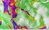


Skialpinistická túra na Weisskugel je obtížná především svou délkou. Začátek túry se liší podle sněhové situace. Když je málo sněhu, jde se po rampě, víceméně po vrstevnici k ledovci Hintereisferner. Po ledovci mírně nahoru západním směrem. Prudký je až výšvih do sedla Hintereisjoch, odkud se stoupá doprava, severním směrem k vrcholu. Poslední desítky metrů vedou exponovaným terénem, hodně záleží na množství sněhu.
Peak
- Country
- Austria
- Montains
- Ötztal Alps / Alpi Venoste
- Tags
- Austria Ötztal Ötztaler Alpen Tirol Vent
- Hut
- Hochjoch Hospiz
- UTM / CH1903 x ("longitude" E/W)
- 32T 631764
- UTM / CH1903 y ("latitude" N/S)
- 5184195
Start point
- Start Point
- Hochjoch Hospiz
- Altitude
- 2413 m
- UTM / CH1903 x ("longitude" E/W)
- 32T 639906
- UTM / CH1903 y ("latitude" N/S)
- 5187362
- village, valley
- Vent
Conditions
- Avalanche danger
- lawine.at
- Weather
- Hochjoch Hospiz / meteoblue.com Bergwetter Tirol 2 days Vent, snow-forecast.com Guslarspitzen 3147 / mountain-forecast.com Fineilspitze 3514 / mountain-forecast.com Fluchtkogel / meteoblue.com Weisskugel 3739 m / mountain-forecast.com Alpenvereinswetter wetter.at - Austria ZAMG - Austria ORF Wetter
- Snow report
- Vent / bergfex.at Vent / snow-forecast.com Sölden / schneeradar.de Sölden / onthesnow.com
- Webcams
- Vernagthütte Vent Rif. Bella Vista / Schöne Aussicht Hütte Sölden-Rettenbachgletscher
Ski tour map on Weisskugel East, from Hochjoch Hospiz


 bivakovací nouzová chata
  cepín a mačky potřeba
 exponovaný, obtížný terén
 horská chata
 hôtel, penzion
 lanovka, vlek
 lavinové nebezpečí, svah > 30°
 ledovcové trhliny
 lehká túra
 mimořádně obtížná túra
 mírně obtížná túra
 obtížná túra
 parkoviště
 přístup k chatě
 restaurace
 sedlo
sedlo sjezd
sjezd skidepo
 vrchol
 výstup
 začátek ledovce
- bivouac, winter room
- crampons & ice axe necessary
- exposed, difficulty terrain
- mountain hut, refuge
- hotel, pension
- cableway, skilift
- avalanche danger, slope > 30°
- glacier cracks
- little difficult tour
- extremely difficult tour
- rather difficult tour
- difficult tour
- parking
- hut acces
- restaurant
- col, pass, saddle
- descent
- skidepot
- peak, summit
- ascent
- glacier beginning
- biwak, winterraum
- steigeisen & pickel erforderlich
- ausgesetzt, schwierige gelände
- berghütte
- hotel, pension
- seilbahn, skilift
- lawinengefahr, hangneigung > 30°
- gletscherspalten
- wenig schwierige tour
- äusserst schwierige tour
- ziemlich schwierige tour
- schwierige tour
- parkplatz
- zugang zur hütte
- restaurant
- sattel, joch, pass
- abfahrt
- skidepot
- gipfel
- aufsieg
- gletscher anfang
- bivacco, locale invernale
- ramponi & piccozza necessari
- esposto, terreno difficolt?
- rifugio, capanna
- alberghi, pensione
- funivia, seggiovia
- pericolo di valanghe, pendenza > 30°
- crepe glacier
- tour piccolo difficile
- tour estremamente difficile
- tour piuttosto difficile
- escursioni difficili
- parcheggio
- accesso capanna
- ristorante
- col, sella, passo, forcella
- discesa
- sci deposito
- picco, vertice, piz
- salita
- inizio ghiacciaio
- bivouac, local d'hiver
- crampons & piolet nécessaire
- exposée, difficulté du terrain
- cabane de montagne, refuge
- hôtel, pension
- téléphérique, téléski
- danger d'avalanche, pente > 30°
- crevasse du glacier
- peu difficile tour
- extr?mement difficile tournée
- assez difficile tour
- difficile tournée
- parking
- acces cabane
- restaurant
- col, selle
- descente
- skis dépôt
- pic, sommet
- ascension
- début glacier
- < 20°
- 20° - 25°
- 25° - 30°
- 30° - 35°
- 35° - 40°
- > 40°
Current weather conditions in the tour area
Planning of ski tour
- Fitness difficulty
-
- ♦♦♦♦
- Technical difficulty
-
- ♦♦♦◊
- best time for this tour
- march - may
- Glacier
- Yes
- Map
- Weisskugel, OEAV 1:25000, Nr. 30/2
- Guides
- Ötztal – Silvretta / Bergverlag Rother, deusch SCHITOUREN-ATLAS ÖSTERREICH WEST / Schall Verlag, deusch Skitourenführer Ötztaler Alpen / Panico, deusch
About Ski tour
- Time difficulty
- Ascent (height difference)
- 1550 m
- Lenght of ascent
- 11 km
- Descent (height difference)
- 1550 m
- Total Lenght of tour
- 22 km
- Total time of the tour
- 7-10 h
- Elevation Range
- 2360 - 3739 m
- Principal Aspect
- E, NE, S S-south, N-north, W-west, E-east
Download
- GPX (track only)
- Weisskugel HochjH_TRK.gpx best for display on a detailed topographical map (mapy.cz) or in apps for smartphones (Locus, Garmin Connect, etc.)
- GPX (waipoints, track)
- Weisskugel_HochjochHospiz_skitour.gpx great for uploading in GPS device
- KML (with POI)
- Weisskugell_HochjochHospiz_skitour.kml for viewing in the Google Earth 3D map application, which you can install on your PC
Current avalanche potential on tour - Weisskugel East, from Hochjoch Hospiz

tour Weisskugel East, from Hochjoch Hospiz - Reviews
There are no reviews in this section yet. Click the Add Review button to add first review.
Ski tours around Hut Hochjoch Hospiz, in mountains Ötztal Alps / Alpi Venoste, Austria
-
Finailspitze North (from Hochjoch Hospiz) 3514 m
Hochjoch Hospiz Ötztal Alps / Alpi Venoste Austria
- Length of ascent7 km
- ascent1390 m
- duration5,5-7 h
- Fitness difficulty ♦♦♦◊
- Technical difficulty ♦♦♦◊
The tour to Fineilspitze begins with a short descent from the Hochjoch Hospiz hut into the valley of the Rofenache stream. Cross the stream and ascend on the right-hand side above the gorge. After the valley widens, continue left up over a moraine onto the glacier. On the glacier, head right of the ridge to a point at 3447 m. Leave the skis there and continue without them, using crampons, over exposed terrain along the ridge to the summit. Descent follows the ascent route.

-

Guslarspitze S, from Hochjoch Hospiz 3138 m
Hochjoch Hospiz Ötztal Alps / Alpi Venoste Austria
- Length of ascent3 km
- ascent720 m
- duration2-3 h
- Fitness difficulty ♦♦◊◊
- Technical difficulty ♦♦◊◊
Túra na Guslarspitze z chaty Hochjoch Hospiz není příliš náročná. Stoupá se přímo z chaty jižním svahem. Sklon svahu se plynule zvětšuje. Po vrcholovém hřebenu je to kousek ke kříži. Sjezd po trase výstupu. Přes Guslarspitze vede nejjednodušší trasa k chatě Vernagthütte.
-

Fluchtkogel S, from Hochjoch Hospiz 3500 m
Hochjoch Hospiz Ötztal Alps / Alpi Venoste Austria
- Length of ascent6 km
- ascent1130 m
- duration3,5-5 h
- Fitness difficulty ♦♦♦◊
- Technical difficulty ♦♦◊◊
Skialpová túra na Fluchtkogel z chaty Hochjoch Hospiz slibuje zajímavý výstup a skvělý výhled z vrcholu. Od chaty traverzem mírně vzhůru (ne moc doprava nahoru) tak, abyste dosáhli spodního okraje ledovcového karu. Úzkým koridorem po prudším výšvihu ke spodnímu okraji ledovce Kesselwandferner. Po mírném rozlehlém ledovci k sedlu Guslarjoch. Závěr výstupu na plochý vrchol je po místy prudkém svahu. Pokud chcete sjet k chatě Vernagthütte, z vrcholu sjeďtze k sedlu Guslarjoch a po ledovci Guslarferner a následně členitým terénem k chatě. V případě návratu na Hochjoch Hospiz sjezd po trase výstupu.
Best ski tours in Ötztal Alps / Alpi Venoste by skitour.guru
-

Hohe Wilde / Hochwilde 3461 m
Langtalereckhütte Ötztal Alps / Alpi Venoste Austria
- Length of ascent8 km
- ascent1040 m
- duration6-8 h
- Fitness difficulty ♦♦♦◊
- Technical difficulty ♦♦♦♦
Hohe Wilde (Langtalereck Hütte, Ötztaler Alpen) is a distinctive mountain at the end of the Langtaler Ferner glacier with a challenging finisch to the summit.
-
Hintere Schwärze 3624 m
Martin-Busch-Hütte Ötztal Alps / Alpi Venoste Austria
- Length of ascent6,5 km
- ascent1300 m
- duration5,5-7 h
- Fitness difficulty ♦♦◊◊
- Technical difficulty ♦♦♦◊
Hintere Schwärze je vrchol, schovaný trošku stranou. Patří mezi top10 nejvyšších hor Rakouska. Po sjezdu od chaty se trasa stáčí doprava na ledovec Marzellferner. Po ledovci mírně nahoru. Následuje prudší svah k závěrečnému výšvihu. Od skidepa v mačkách a s cepínem na vrchol, jednoduchým terénem.
-
Fluchtkogel SE, from Vernagthütte 3500 m
Vernagthütte Ötztal Alps / Alpi Venoste Austria
- Length of ascent4 km
- ascent740 m
- duration3-4,5 h
- Fitness difficulty ♦♦♦◊
- Technical difficulty ♦♦◊◊
Túra na Fluchtkogel z Vernagthütte je výletem za krásnými výhledy přes celé Ötztálské Alpy. Jediný prudší úsek je pod sedle Oberes Guslarjoch a ještě v závěrečném svahu na plochý vrchol. Dolů kolem výstupových stop.