
 Česky
Česky Deutsch


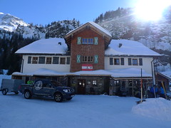


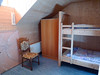

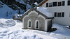
Great hut over Rauris in a place nicknamed Schneeloch - a snow hole. Great long hikes to Hoher Sonnblick, Hocharn and to Kolmkarspitze, Silberpfennig in the mountain group of Goldberggruppe in Hohe Tauern.
Tours starting from hut
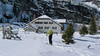
Ski tours around Hut Kolm Saigurn - Sonnblickbasis
-

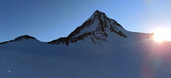
Hocharn 3254 m
Kolm Saigurn - Sonnblickbasis Goldberg Gruppe - Hohe Tauern Austria
- Length of ascent6 km
- ascent1700 m
- duration5,5-8,5 h
- Fitness difficulty ♦♦♦◊
- Technical difficulty ♦♦◊◊
Hocharn (Goldberggruppe - Hohe Tauern) is a spectacular backcountry skiing tour of the West-Alps character, with an elevation of 1700 m. A wonderful downhill variant is under the northern wall of Sonnblick. From the hut Kolm Saigurn or from the Lenzagerboden parking.

-
Kolmkarspitze 2492 m
Kolm Saigurn - Sonnblickbasis Goldberg Gruppe - Hohe Tauern Austria
- Length of ascent4 km
- ascent950 m
- duration4-5 h
- Fitness difficulty ♦♦◊◊
- Technical difficulty ♦♦◊◊
Kolmkarspitze (Kolm Saigurn, Goldberggruppe - Hohe Tauern) is a less challenging tour in the Rauris area. Slopes of up to 30° promise safe tour even under worse conditions.
-

Wintergasse 2244 m
Kolm Saigurn - Sonnblickbasis Goldberg Gruppe - Hohe Tauern Austria
- Length of ascent2 km
- ascent400 m
- duration2-3 h
- Fitness difficulty ♦♦◊◊
- Technical difficulty ♦♦◊◊
Wintergasse (Goldberggruppe - Hohe Tauern) is the ideal gorge for the extension Hoher Sonnblick ski tour. Ascent goes sideways and downhill ride through the northern exposition of a constant slope of 30 degrees.
-

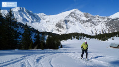
Hoher Sonnblick 3105 m
Kolm Saigurn - Sonnblickbasis Goldberg Gruppe - Hohe Tauern Austria
- Length of ascent8 km
- ascent1507 m
- duration5-7 h
- Fitness difficulty ♦♦♦◊
- Technical difficulty ♦♦◊◊
Hoher Sonnblick (Goldberggruppe - Hohe Tauern) is a popular tour from Kolm Saigurn Hut. At the top you can have a beer at the Zittelhaus cottage. Excellent alpine ski school, downhill slopes of various expositions and snow.
- Country
- Austria
- Montains
- Goldberg Gruppe - Hohe Tauern
- Open (winter)
- all winter
- Beds
- 60
- Winterraum
- 0
- Shortening of access (cableway, lift, taxi, snowcat...)
- by car from parking Bodenhaus
- UTM / CH1903 x ("longitude" E/W)
- 33T 346932
- UTM / CH1903 y ("latitude" N/S)
- 5214683
- GPX access to hut (waipoints, track)
- KOLM SAIGURN_all_wpt_tracks.gpx
- Map
- Sonnblick, OEAV 1:25000, Nr. 42
- Guides
- Skitourenführer Österreich Band1 SCHITOUREN-ATLAS ÖSTERREICH WEST DAS PERFEKTE SCHITOUREN-WOCHENENDE
- Phone (hut)
- +43(0)6544/8103
- Phone (valley)
- -
- Cell phone
- -
- Web
- -
- sonnblickbasis@naturfreunde.at
- Owner of hut
- Naturfreunde
- Sonnblickbasis kolm saigurn
- Start Point
- Rauris - Parkplatz Bodenhaus
- UTM / CH1903 x ("longitude" E/W)
- 33 T 347642
- UTM / CH1903 y ("latitude" N/S)
- 5218731
- Altitude
- 1230 m
- Ascent (height difference)
- 370 m
- Time of Access
- 2 h
- Shortening lift
- yes, cheap taxi from hut
- Start Point
- Parkplatz Lenzager
- UTM / CH1903 x ("longitude" E/W)
- 33 T 347051
- UTM / CH1903 y ("latitude" N/S)
- 5216162
- Altitude
- 1550 m
- Ascent (height difference)
- 50 m
- Time of Access
- 0,5 h
- Shortening lift
- -
- Avalanche danger
- lawine.at - Salzburger Land
- Weather
- ZAMG ORF Alpenverein yr.no - Kolm Saigurn yr.no - Hoher Sonnblick
- Snow report
- bergfex.at snow-forecast.com schneeradar.de
- Webcams
- foto-webcam.eu Feratel Webcams Travel snow-forecast.com
- Region
- Rauristal
- Public traffic
- Postbus ÖBB Railway
- Skiresort nearby
- Rauris Bad Gastein
- Other links
- NP Hohe Tauern
hut Kolm Saigurn - Sonnblickbasis - Reviews
There are no reviews in this section yet. Click the Add Review button to add first review.
Best ski tours in Austria by skitour.guru
-

Nördliche Augstenspitze Circuit 3228 m
Jamtalhütte Silvretta Austria
- Length of ascent10 km
- ascent1450 m
- duration6-8 h
- Fitness difficulty ♦♦♦◊
- Technical difficulty ♦♦♦◊
Nördliche Augstenspitze is a comprehensive and varied skitour from the Jamtalhütte. First goes to the saddle through the Chalausferner glacier to Fuorcla chalaus saddle, usually in crampons. Short descent to the Oberer Augstenferner Glacier. At the end in crampons and with ice ax to the top. A possible alternative is to extend the tour through Urezzasjoch.
-
Finailspitze North (from Hochjoch Hospiz) 3514 m
Hochjoch Hospiz Ötztal Alps / Alpi Venoste Austria
- Length of ascent7 km
- ascent1390 m
- duration5,5-7 h
- Fitness difficulty ♦♦♦◊
- Technical difficulty ♦♦♦◊
The tour to Fineilspitze begins with a short descent from the Hochjoch Hospiz hut into the valley of the Rofenache stream. Cross the stream and ascend on the right-hand side above the gorge. After the valley widens, continue left up over a moraine onto the glacier. On the glacier, head right of the ridge to a point at 3447 m. Leave the skis there and continue without them, using crampons, over exposed terrain along the ridge to the summit. Descent follows the ascent route.
-

Östliche Seespitze 3416 m
Franz Senn Hütte Stubai Alps Austria
- Length of ascent6,5 km
- ascent1270 m
- duration6-8 h
- Fitness difficulty ♦♦♦◊
- Technical difficulty ♦♦♦◊
Östliche Seespitze (Franz Senn Hütte, Stubaier Alpen) is a glacier tour with a steep passage (30-35°). At the end without skiing along the ridge to the summit.