
 Česky
Česky Deutsch


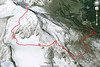

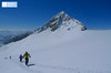
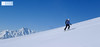
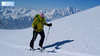
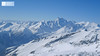
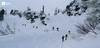
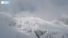
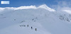
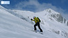
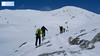

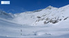
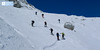
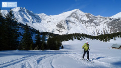
Hoher Sonnblick (Goldberggruppe - Hohe Tauern) is a popular tour from Kolm Saigurn Hut. At the top you can have a beer at the Zittelhaus cottage. Excellent alpine ski school, downhill slopes of various expositions and snow.
Peak
- Country
- Austria
- Montains
- Goldberg Gruppe - Hohe Tauern
- Tags
- Goldberggruppe Hohe Tauern Kolm Saigurn Rauris
- Hut
- Kolm Saigurn - Sonnblickbasis
- UTM / CH1903 x ("longitude" E/W)
- 33 T 344875
- UTM / CH1903 y ("latitude" N/S)
- 5213191
Start point
- Start Point
- Sonnblickbasis - Kolm Saigurn
- Altitude
- 1598 m
- UTM / CH1903 x ("longitude" E/W)
- 33T 346932
- UTM / CH1903 y ("latitude" N/S)
- 5214683
- village, valley
- Rauris - Parkplatz Bodenhaus
- cableway / lift
- no
Conditions
- Avalanche danger
- lawine.at - Salzburger Land
- Weather
- ZAMG ORF Alpenverein yr.no - Kolm Saigurn yr.no - Hoher Sonnblick
- Snow report
- bergfex.at snow-forecast.com schneeradar.de
- Webcams
- foto-webcam.eu Feratel Webcams Travel snow-forecast.com
Ski tour map on Hoher Sonnblick


 bivakovací nouzová chata
  cepín a mačky potřeba
 exponovaný, obtížný terén
 horská chata
 hôtel, penzion
 lanovka, vlek
 lavinové nebezpečí, svah > 30°
 ledovcové trhliny
 lehká túra
 mimořádně obtížná túra
 mírně obtížná túra
 obtížná túra
 parkoviště
 přístup k chatě
 restaurace
 sedlo
sedlo sjezd
sjezd skidepo
 vrchol
 výstup
 začátek ledovce
- bivouac, winter room
- crampons & ice axe necessary
- exposed, difficulty terrain
- mountain hut, refuge
- hotel, pension
- cableway, skilift
- avalanche danger, slope > 30°
- glacier cracks
- little difficult tour
- extremely difficult tour
- rather difficult tour
- difficult tour
- parking
- hut acces
- restaurant
- col, pass, saddle
- descent
- skidepot
- peak, summit
- ascent
- glacier beginning
- biwak, winterraum
- steigeisen & pickel erforderlich
- ausgesetzt, schwierige gelände
- berghütte
- hotel, pension
- seilbahn, skilift
- lawinengefahr, hangneigung > 30°
- gletscherspalten
- wenig schwierige tour
- äusserst schwierige tour
- ziemlich schwierige tour
- schwierige tour
- parkplatz
- zugang zur hütte
- restaurant
- sattel, joch, pass
- abfahrt
- skidepot
- gipfel
- aufsieg
- gletscher anfang
- bivacco, locale invernale
- ramponi & piccozza necessari
- esposto, terreno difficolt?
- rifugio, capanna
- alberghi, pensione
- funivia, seggiovia
- pericolo di valanghe, pendenza > 30°
- crepe glacier
- tour piccolo difficile
- tour estremamente difficile
- tour piuttosto difficile
- escursioni difficili
- parcheggio
- accesso capanna
- ristorante
- col, sella, passo, forcella
- discesa
- sci deposito
- picco, vertice, piz
- salita
- inizio ghiacciaio
- bivouac, local d'hiver
- crampons & piolet nécessaire
- exposée, difficulté du terrain
- cabane de montagne, refuge
- hôtel, pension
- téléphérique, téléski
- danger d'avalanche, pente > 30°
- crevasse du glacier
- peu difficile tour
- extr?mement difficile tournée
- assez difficile tour
- difficile tournée
- parking
- acces cabane
- restaurant
- col, selle
- descente
- skis dépôt
- pic, sommet
- ascension
- début glacier
- < 20°
- 20° - 25°
- 25° - 30°
- 30° - 35°
- 35° - 40°
- > 40°
Current weather conditions in the tour area
Planning of ski tour
- Fitness difficulty
-
- ♦♦♦◊
- Technical difficulty
-
- ♦♦◊◊
- best time for this tour
- March-May
- Glacier
- Yes
- Map
- Sonnblick, OEAV 1:25000, Nr. 42
- Guides
- SCHITOURENFÜHRER ÖSTERREICH Band I SCHITOUREN-ATLAS ÖSTERREICH WEST DAS PERFEKTE SCHITOUREN-WOCHENENDE
About Ski tour
- Time difficulty
- Ascent (height difference)
- 1507 m
- Lenght of ascent
- 8 km
- Descent (height difference)
- 1507 m
- Total Lenght of tour
- 16 km
- Total time of the tour
- 5-7 h
- Elevation Range
- 1598 - 3105 m
- Principal Aspect
- N, E, S S-south, N-north, W-west, E-east
Download
- GPX (track only)
- Sonnblick_3105m_TRACK.gpx best for display on a detailed topographical map (mapy.cz) or in apps for smartphones (Locus, Garmin Connect, etc.)
- GPX (waipoints, track)
- Hoher Sonnblick 3105 AUT SkitourGuru.gpx great for uploading in GPS device
- KML (with POI)
- Hoher Sonnblick TOURmap.kml for viewing in the Google Earth 3D map application, which you can install on your PC
Current avalanche potential on tour - Hoher Sonnblick

tour Hoher Sonnblick - Reviews
There are no reviews in this section yet. Click the Add Review button to add first review.
Ski tours around Hut Kolm Saigurn - Sonnblickbasis, in mountains Goldberg Gruppe - Hohe Tauern, Austria
-

Wintergasse 2244 m
Kolm Saigurn - Sonnblickbasis Goldberg Gruppe - Hohe Tauern Austria
- Length of ascent2 km
- ascent400 m
- duration2-3 h
- Fitness difficulty ♦♦◊◊
- Technical difficulty ♦♦◊◊
Wintergasse (Goldberggruppe - Hohe Tauern) is the ideal gorge for the extension Hoher Sonnblick ski tour. Ascent goes sideways and downhill ride through the northern exposition of a constant slope of 30 degrees.

-
Kolmkarspitze 2492 m
Kolm Saigurn - Sonnblickbasis Goldberg Gruppe - Hohe Tauern Austria
- Length of ascent4 km
- ascent950 m
- duration4-5 h
- Fitness difficulty ♦♦◊◊
- Technical difficulty ♦♦◊◊
Kolmkarspitze (Kolm Saigurn, Goldberggruppe - Hohe Tauern) is a less challenging tour in the Rauris area. Slopes of up to 30° promise safe tour even under worse conditions.
-

Hocharn 3254 m
Kolm Saigurn - Sonnblickbasis Goldberg Gruppe - Hohe Tauern Austria
- Length of ascent6 km
- ascent1700 m
- duration5,5-8,5 h
- Fitness difficulty ♦♦♦◊
- Technical difficulty ♦♦◊◊
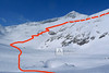
Hocharn (Goldberggruppe - Hohe Tauern) is a spectacular backcountry skiing tour of the West-Alps character, with an elevation of 1700 m. A wonderful downhill variant is under the northern wall of Sonnblick. From the hut Kolm Saigurn or from the Lenzagerboden parking.