
 Česky
Česky Deutsch


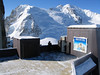


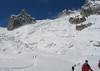


Vallée Blanche is a legendary descent between the famous granite towers above Chamonix. Take the cable car from Chamonix to the Aiguille du Midi and various exits from there. Beware of glacier cracks! From Mer de Glace to the train (Montevers station) you can take the cable car or get off with skins. In the middle of the descent, refreshment is possible in the Refuge du Requin. This descent is mainly panoramic as a skiing enjoyment...
Peak
- Country
- France
- Montains
- Massif Mont Blanc
- Tags
- France Haute Route Chamonix-Zermatt Haute Savoie Chamonix-Mont-Blanc Massif Mont Blanc Mont Blanc Valée Blanche
- Hut
- Chamonix-Mont-Blanc
- UTM / CH1903 x ("longitude" E/W)
- 32T 336054
- UTM / CH1903 y ("latitude" N/S)
- 5082772
Start point
- Start Point
- Chamonix-Mont-Blanc
- Altitude
- 1030 m
- UTM / CH1903 x ("longitude" E/W)
- 32T 334857
- UTM / CH1903 y ("latitude" N/S)
- 5087709
Conditions
- Avalanche danger
- Meteo France - Haute Savoie
- Weather
- Chamonix Mont-Blanc / meteofrance.com Aiguille Du Midi 3842m / mountain-forecast.com Le Brévent 2525m / mountain-forecast.com Grands Montets 3295m / mountain-forecast.com Aig. Chardonnet 3824m / mountain-forecast.com Petit Dru 3733m / mountain-forecast.com Grands Montets, meteoblue.com Argentiére, meteoblue.com Chamonix, snow-forecast.com
- Snow report
- Chamonix - Grands Montets, bergfex.ch Chamonix - Grands Montets, skiresort.info Chamonix, snow-forecast.com Chamonix, onthesnow.com
- Webcams
- Aiguille di Midi Chamonix, all webcams
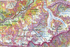
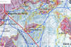
Ski tour map on Vallée Blanche - freeride


 bivakovací nouzová chata
  cepín a mačky potřeba
 exponovaný, obtížný terén
 horská chata
 hôtel, penzion
 lanovka, vlek
 lavinové nebezpečí, svah > 30°
 ledovcové trhliny
 lehká túra
 mimořádně obtížná túra
 mírně obtížná túra
 obtížná túra
 parkoviště
 přístup k chatě
 restaurace
 sedlo
sedlo sjezd
sjezd skidepo
 vrchol
 výstup
 začátek ledovce
- bivouac, winter room
- crampons & ice axe necessary
- exposed, difficulty terrain
- mountain hut, refuge
- hotel, pension
- cableway, skilift
- avalanche danger, slope > 30°
- glacier cracks
- little difficult tour
- extremely difficult tour
- rather difficult tour
- difficult tour
- parking
- hut acces
- restaurant
- col, pass, saddle
- descent
- skidepot
- peak, summit
- ascent
- glacier beginning
- biwak, winterraum
- steigeisen & pickel erforderlich
- ausgesetzt, schwierige gelände
- berghütte
- hotel, pension
- seilbahn, skilift
- lawinengefahr, hangneigung > 30°
- gletscherspalten
- wenig schwierige tour
- äusserst schwierige tour
- ziemlich schwierige tour
- schwierige tour
- parkplatz
- zugang zur hütte
- restaurant
- sattel, joch, pass
- abfahrt
- skidepot
- gipfel
- aufsieg
- gletscher anfang
- bivacco, locale invernale
- ramponi & piccozza necessari
- esposto, terreno difficolt?
- rifugio, capanna
- alberghi, pensione
- funivia, seggiovia
- pericolo di valanghe, pendenza > 30°
- crepe glacier
- tour piccolo difficile
- tour estremamente difficile
- tour piuttosto difficile
- escursioni difficili
- parcheggio
- accesso capanna
- ristorante
- col, sella, passo, forcella
- discesa
- sci deposito
- picco, vertice, piz
- salita
- inizio ghiacciaio
- bivouac, local d'hiver
- crampons & piolet nécessaire
- exposée, difficulté du terrain
- cabane de montagne, refuge
- hôtel, pension
- téléphérique, téléski
- danger d'avalanche, pente > 30°
- crevasse du glacier
- peu difficile tour
- extr?mement difficile tournée
- assez difficile tour
- difficile tournée
- parking
- acces cabane
- restaurant
- col, selle
- descente
- skis dépôt
- pic, sommet
- ascension
- début glacier
- < 20°
- 20° - 25°
- 25° - 30°
- 30° - 35°
- 35° - 40°
- > 40°
Current weather conditions in the tour area
Planning of ski tour
- Fitness difficulty
-
- ♦♦◊◊
- Technical difficulty
-
- ♦♦◊◊
- best time for this tour
- March-May
- Glacier
- Yes
- Map
- Chamonix 3630, IGN 1:25000 Martigny 282 S, Swisstopo 1:50000
- Guides
- Ski de Randonnée autour du Mont Blanc (JM Editions, francais) Haute Route (Rother, deutsch) Haute Route Chamonix-Zermatt (JM editions, french) Die klassischen Skitouren (SAC, deutsch) Les classiques de randonnée à ski (SAC, francais)
About Ski tour
- Time difficulty
- Ascent (height difference)
- 110 m
- Lenght of ascent
- 0,5 km
- Descent (height difference)
- 1950 m
- Total Lenght of tour
- 12,5 km
- Total time of the tour
- 2,5-3,5 h
- Elevation Range
- 1800 - 3842 m
- Principal Aspect
- S, SE, E, NE, N S-south, N-north, W-west, E-east
Download
- GPX (track only)
- Valee-Blanche_Montenvers_TRK.gpx best for display on a detailed topographical map (mapy.cz) or in apps for smartphones (Locus, Garmin Connect, etc.)
- GPX (waipoints, track)
- Valee-Blanche_Montevers_skitour.gpx great for uploading in GPS device
- KML (with POI)
- ValeeBlanche-Montevers_skitour_Guru.kml for viewing in the Google Earth 3D map application, which you can install on your PC
