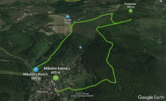
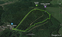
Do cesty nastupujeme asi 20 m nad společným vyústění sjezdovky č. 3 a 4. Ze sjezdovky zahneme ostře vlevo do lesního porostu a po cca 100m se dostaneme na skalní hřebínek, po kterém pokračujeme ve výstupu až pod obrovský buk, kolem kterého obtížně „cik-cak“ vystupujeme asi 20 m příkrým srázem na cestu. Odbočíme vpravo a pokračujeme po cestě až k ostré zatáčce pod hrází potoka. Zde uhýbáme ostře vlevo příkrým úbočím směrem k pravé části hráze. Od ní pokračujeme dále šikmo vlevo vzhůru podél potoka cca 300 m. U velkého buku ostře doprava (jedna varianta pokračuje rovně podél potoka – neprokáceno !!!) a po traverzové cestě k otočce doleva do vrcholového 150m traverzu, který vede vlevo svahem. Dále stopa uhýbá ostře vpravo za výraznou prohlubní, kterou míjíme po pravé ruce. Jsme na vrcholu sjezdovky č. 4. Odtud lze pokračovat dále po tyčovém značení kolem stanice Horské služby až na vrchol Bouřňáku a nebo sjet do Mikulova sjezdovkou č. 4.
Peak
- Country
- Czech
- Montains
- Krušné hory
- Tags
- Bouřňák české hory Hrob Krušné hory Mikulov v Krušných horách skialpujdoma
- Hut
- Skialp nad Hrobem - Bouřňák
- UTM / CH1903 x ("longitude" E/W)
- 33U 408673
- UTM / CH1903 y ("latitude" N/S)
- 5615705
Start point
- Start Point
- Bouřňák - Skialp nad Hrobem - Krušné hory
- Altitude
- 585 m
- UTM / CH1903 x ("longitude" E/W)
- 33U 409464
- UTM / CH1903 y ("latitude" N/S)
- 5615968
- Participed on tour mapping
- skialpmadhrobem.cz, www.skialpnadhrobem.cz
Planning of ski tour
- Fitness difficulty
-
- ♦◊◊◊
- Technical difficulty
-
- ♦◊◊◊
- best time for this tour
- all winter
- Glacier
- No
- Map
- Krušné hory - východ, 1:25000, Geodézie On-Line
- Guides
- Skitour.Guru
About Ski tour
- Time difficulty
- Ascent (height difference)
- 305 m
- Lenght of ascent
- 2 km
- Descent (height difference)
- 305 m
- Total Lenght of tour
- 3 km
- Total time of the tour
- 1-1,5 h
- Elevation Range
- 585 - 869 m
- Principal Aspect
- E S-south, N-north, W-west, E-east
Download
- GPX (track only)
- Bournak_Pilousova TRACK.gpx best for display on a detailed topographical map (mapy.cz) or in apps for smartphones (Locus, Garmin Connect, etc.)
- GPX (waipoints, track)
- Bournak_Pilousova_SKITOUR.gpx great for uploading in GPS device
tour Bouřňák - Pilousova - Reviews
There are no reviews in this section yet. Click the Add Review button to add first review.
Ski tours around Hut Skialp nad Hrobem - Bouřňák, in mountains Krušné hory, Czech
-

Pramenáč - Křížová 909 m
Skialp nad Hrobem - Bouřňák Krušné hory Czech
- Length of ascent2,5 km
- ascent345 m
- duration1,5-2,5 h
- Fitness difficulty ♦◊◊◊
- Technical difficulty ♦◊◊◊
Výstup začíná na konci Růžové ulice v Mikulově u kašny. Odtud se vydáme doprava mezi domy do strmého kopce. Úvozovou cestou dojdeme k mostku pod tratí, za ním se dáme doleva a stoupá- me po cestě příkře až na křižovatku, kterou přecházíme rovně na cestu.Z ní po 30m odbočujeme doleva mezi stromky a jdeme po lesní pěšině vzhůru lesem. Dojdeme na silnici (Dubí-Vitiška), kterou přejdeme a opět se vnoříme do lesa. Za lesem vyjdeme doleva na mýtinu s menšími stromky, po ní po cestách za stálého stoupání mírně vlevo a po 200m ostře doprava a hned doleva. Dlouhou rovnou cestou se dostaneme na polní cestu, na ní doleva a za 200m dojdeme ke dřevěné stavbě odpočívadla. Od něj doprava po cestě na vrchol Pramenáč. Z Pramenáče na Bouřňák se dostaneme po turistické cestě přes Vitišku, na které jsou v zimě běžecké stopy. Sjezd začíná na vrcholu Pramenáče u vrcholového kříže. S křížem v za zády se vydáme doprava dolů po cestě, která se po 250m u odpočívadla napojuje na další cestu. Na této křižovatce odbočíme vpravo jedeme stále mírně dolů. Po chvíli cesta tvoří ostrou levou zatáčku. Dále se pak cesta mírně vlní a po 750m po ní dojedeme na pěticestí u chaty Mikuláška. Zde sjezd pokračuje mírně vlevo dolů úvozovou cestou, která po 100m vyústí na Hönigovka- sjezd. Od chaty Vitiška na konci vleku lze použít cestu vedoucí v pravém úbočí svahu. Podstatné je držet se nalevo od vleku pod el. vedením. Na konci úbočí vede cesta nad vlakovým tunelem, kde zatáčí vlevo. Náš sjezd v tomto místě cestu opouští a směřuje kolmo dolů pod elektrickým vedením, kde nám ČEZ vyřezal krásný úsek volného sjezdu plného prahů a členitostí. Po té elektrické vedení překračuje sinici a my rovněž a za svodidlem nás ještě čeká kousek sjezdu volným terénem až k pokladně Skicentra Bouřňák.

-

Bouřňák - Mikulovská 869 m
Skialp nad Hrobem - Bouřňák Krušné hory Czech
- Length of ascent2 km
- ascent300 m
- duration1-1,5 h
- Fitness difficulty ♦◊◊◊
- Technical difficulty ♦◊◊◊
Výstupová trasa začíná přímo na parkovišti v Mikulově. Jezírko budete mít po pravé straně, parkoviště za zády a před sebou uvidíte první značku (výstup=zelená šipka). Průsekem stoupáme vzhůru přes 1. až na 2. cestu, po které zahýbáme vlevo. Jdeme asi 300 m do levotočivé zatáčky, ve které uhýbáme z cesty doprava strmým výšvihem. Pokračujeme mírně stoupajícím terénem za stálého směřování doprava, blížíme se ke slalomovému svahu, na který vyjdeme cca 200 pod koncem lanovky – kotvy. Jsme na vrcholu Bouřňáku. K sestupu do Mikulova použijte jakoukoliv sjezdovku mimo čísla 6.

-

Bouřňák - Serpentiny pro Macholda 869 m
Skialp nad Hrobem - Bouřňák Krušné hory Czech
- Length of ascent1,5 km
- ascent240 m
- duration1-1,5 h
- Fitness difficulty ♦◊◊◊
- Technical difficulty ♦◊◊◊
Trasa na památku horolezce a lékaře Petra Macholda. Do trasy nastupujeme za můstkem na sjezdovce č. 5 (turistické) v pravém úhlu doleva několika zákrutami se dostaneme na cestu, kterou překřížíme a pokračujeme starou úvozovou cestou vzhůru až ke sjezdovce č. 5 (turistické). Sjezdovku č. 5 překřížíme a pokračujeme dál kolmo svahem. Po levé ruce máme hustý pruh lesa, podél kterého vystoupáme až pod silnici. V tomto místě se dáme vlevo a paralelně se silnicí dojdeme po 200 metrech k rozcestí u trafostanice. Zde znovu vlevo a dojdeme na sjezdovku č. 4. Pokračování je na vás vlevo sjezd po 4ce vpravo výstup po 4ce na Bouřňák po tyčovém značení, nebo zahýbáme vpravo a sjíždíme po sjezdovce č. 5 (turistické) do Mikulova. Nad prudkým sjezdem (vidíme na silnici) lze odbočit doleva a po tzv. „tankovce“ opět zahájíme výstup směrem Bouřňák po Tankovce. Varianta na Bouřňák: nad sjezdovkou č. 4 vyjdeme průsekem na pláně u Horské služby a podél tyčí až na vrchol Bouřňák. Sjezd do Mikulova jakoukoliv sjezdovkou mimo č. 6.

-

Bouřňák - Hrobská 869 m
Skialp nad Hrobem - Bouřňák Krušné hory Czech
- Length of ascent1 km
- ascent150 m
- duration0,5-1 h
- Fitness difficulty ♦◊◊◊
- Technical difficulty ♦◊◊◊
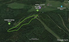
Výstup začíná na sjezdovce č. 6 („jih“, “hrobská“) u začátku vleku – poma . Průsekem stoupáme podél pomy asi 300 m, pak ostře uhýbáme doprava a krátkým sjezdem (na pasech) se dostáváme na cestu. Uhýbáme v pravém úhlu vlevo a po cestě stoupáme vzhůru. Po 400 m se noříme do lesa po levé straně a lesem docházíme na vrchol Bouřňák , kde vycházíme na slalomový svah.

Best ski tours in Krušné hory by skitour.guru
-

Mezihořský Vrch 916 m
Mezihoří - centrální Krušnohoří Krušné hory Czech
- Length of ascent4 km
- ascent360 m
- duration1,5-2,5 h
- Fitness difficulty ♦◊◊◊
- Technical difficulty ♦◊◊◊

-

Klínovec - Fichtelberg 1244 m
Boží Dar - Klínovec Krušné hory Czech
- Length of ascent8,5 km
- ascent1260 m
- duration7-8,5 h
- Fitness difficulty ♦♦◊◊
- Technical difficulty ♦◊◊◊
Dlouhá túra na Klínovec, nejvyšší horu Krušných hor, začíná na Božím Daru. Na několika místech se dá zkrátit. Trasa vede i přes Fichtelberg na německé straně Erzgebirge.

-

Mezihoří - Bernatský vrch - Kalek 838 m
Mezihoří - centrální Krušnohoří Krušné hory Czech
- Length of ascent8,5 km
- ascent535 m
- duration3,5-5 h
- Fitness difficulty ♦♦◊◊
- Technical difficulty ♦◊◊◊


 Česky
Česky Deutsch


