
 Česky
Česky Deutsch


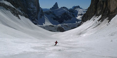
Túra na Dürrenstein / Picco di Vallandro začíná na parkovišti Plätzwiese téměř ve 2000 m n.m. Ptoto je výstup poměrně krátký a patří mezi ty snadnější. Výstup i sjezd vedou po slunných svazích, které až na krátké úseky nepřesahují sklon 30 stupňů. Z masivu Dürrenstein se dají výborně pozorovat Sextenské Dolomity včetně Drei Zinnen / Tre Cime, vrcholy Pragser Dolomiten a velkolepé věže Cristallo i masiv Tofana.
Peak
- Country
- Italy
- Montains
- Dolomiti
- Tags
- Alta Pusteria Alto Adige Dolomiti Dolomiti di Braies Italia Italy Italy Pragser Dolomiten Pustertal South Tyrol
- Hut
- Pragser Dolomiten - Dolomiti di Braies
- UTM / CH1903 x ("longitude" E/W)
- 33T 284707
- UTM / CH1903 y ("latitude" N/S)
- 5172584
Start point
- Start Point
- Parkplatz Plätzwiese
- Altitude
- 1975 m
- UTM / CH1903 x ("longitude" E/W)
- 33T 283899
- UTM / CH1903 y ("latitude" N/S)
- 5170876
Conditions
- Avalanche danger
- Lawinen.report
- Weather
- dolomitimeteo.it Seekofel 2810 m / mountain-forecast.com Dürrenstein 2842 m / mountain-forecast.com Monte Cristallo 3221 m / meteoblue.com Seekofel 2810 m / meteoblue.com alpenverein.at meteo.it
- Snow report
- Kronplatz / bergfex.it Kronplatz / snow-forecast.com Kronplatz / onthesnow.com Cortina - Misurina / bergfex.it
- Webcams
- Prags - Braies Prags - Braies south Kronplatz 2275 Kronplatz - Olang Mittelstation 2070m Prags - Braies Lago Misurina
Ski tour map on Dürrenstein - Picco di Vallandro


 bivakovací nouzová chata
  cepín a mačky potřeba
 exponovaný, obtížný terén
 horská chata
 hôtel, penzion
 lanovka, vlek
 lavinové nebezpečí, svah > 30°
 ledovcové trhliny
 lehká túra
 mimořádně obtížná túra
 mírně obtížná túra
 obtížná túra
 parkoviště
 přístup k chatě
 restaurace
 sedlo
sedlo sjezd
sjezd skidepo
 vrchol
 výstup
 začátek ledovce
- bivouac, winter room
- crampons & ice axe necessary
- exposed, difficulty terrain
- mountain hut, refuge
- hotel, pension
- cableway, skilift
- avalanche danger, slope > 30°
- glacier cracks
- little difficult tour
- extremely difficult tour
- rather difficult tour
- difficult tour
- parking
- hut acces
- restaurant
- col, pass, saddle
- descent
- skidepot
- peak, summit
- ascent
- glacier beginning
- biwak, winterraum
- steigeisen & pickel erforderlich
- ausgesetzt, schwierige gelände
- berghütte
- hotel, pension
- seilbahn, skilift
- lawinengefahr, hangneigung > 30°
- gletscherspalten
- wenig schwierige tour
- äusserst schwierige tour
- ziemlich schwierige tour
- schwierige tour
- parkplatz
- zugang zur hütte
- restaurant
- sattel, joch, pass
- abfahrt
- skidepot
- gipfel
- aufsieg
- gletscher anfang
- bivacco, locale invernale
- ramponi & piccozza necessari
- esposto, terreno difficolt?
- rifugio, capanna
- alberghi, pensione
- funivia, seggiovia
- pericolo di valanghe, pendenza > 30°
- crepe glacier
- tour piccolo difficile
- tour estremamente difficile
- tour piuttosto difficile
- escursioni difficili
- parcheggio
- accesso capanna
- ristorante
- col, sella, passo, forcella
- discesa
- sci deposito
- picco, vertice, piz
- salita
- inizio ghiacciaio
- bivouac, local d'hiver
- crampons & piolet nécessaire
- exposée, difficulté du terrain
- cabane de montagne, refuge
- hôtel, pension
- téléphérique, téléski
- danger d'avalanche, pente > 30°
- crevasse du glacier
- peu difficile tour
- extr?mement difficile tournée
- assez difficile tour
- difficile tournée
- parking
- acces cabane
- restaurant
- col, selle
- descente
- skis dépôt
- pic, sommet
- ascension
- début glacier
- < 20°
- 20° - 25°
- 25° - 30°
- 30° - 35°
- 35° - 40°
- > 40°
Current weather conditions in the tour area
Planning of ski tour
- Fitness difficulty
-
- ♦♦◊◊
- Technical difficulty
-
- ♦♦◊◊
- best time for this tour
- Januar-March
- Glacier
- No
- Map
- Pragser Dolomiten-Dolomiti di Braies, Tabacco 031, 1:25000
- Guides
- Skitouren in den Dolomiten Hochpustertal (de, it - Tappeiner) Scialpinismo in Dolomiti / Versante Sud, italiano Dolomiten / Rother, deutsch
About Ski tour
- Time difficulty
- Ascent (height difference)
- 850 m
- Lenght of ascent
- 4 km
- Descent (height difference)
- 1370 m
- Total Lenght of tour
- 7,5 km
- Total time of the tour
- 3-4 h
- Elevation Range
- 1975 - 2839 m
- Principal Aspect
- S, SW S-south, N-north, W-west, E-east
Download
- GPX (track only)
- Durrenstein TRK.gpx best for display on a detailed topographical map (mapy.cz) or in apps for smartphones (Locus, Garmin Connect, etc.)
- GPX (waipoints, track)
- Durrenstein_Platzwiese_skitour.gpx great for uploading in GPS device
- KML (with POI)
- Durrenstein_Platzwiese_skitour.kml for viewing in the Google Earth 3D map application, which you can install on your PC
Current avalanche potential on tour - Dürrenstein - Picco di Vallandro

tour Dürrenstein - Picco di Vallandro - Reviews
There are no reviews in this section yet. Click the Add Review button to add first review.
Ski tours around Hut Pragser Dolomiten - Dolomiti di Braies, in mountains Dolomiti, Italy
-

Seekofel - Croda del Becco 2810 m
Pragser Dolomiten - Dolomiti di Braies Dolomiti Italy
- Length of ascent8 km
- ascent1370 m
- duration5-6,5 h
- Fitness difficulty ♦♦♦◊
- Technical difficulty ♦♦◊◊
Skialpová túra na Seekofel (italsky Croda del Becco) od jezera Pragser Wildsee (Lago di Braies( slibuje velký vyhlídkový zážitek, jak už to bývá u túr v Dolomitech. Nádherné skály lemující jezero a následně výstup údolíčkem a členitým terénem na náhorní plošinu. Následuje odbočka vravo, západním směrem a nad chatou Seekofelhütte do sedla Ofenscharte / Forcella della Forno. Odtud po hřebenu (často vyfoukaný) na vrchol. Letecký pohled na jezero Pragser Wildsee i protější vrchol Kleine Gaisl. V dáli je vidět Tofana i TreCime di Lavaredo. Sjezd po trase výstupu s možností varianty západně od výstupové linie.

-

Kleine Gaisl - Croda Rossa Piccada 2859 m
Pragser Dolomiten - Dolomiti di Braies Dolomiti Italy
- Length of ascent10,5 km
- ascent1690 m
- duration6-8 h
- Fitness difficulty ♦♦♦♦
- Technical difficulty ♦♦♦◊
Skialpinistická túra na Kleine Gaisl (italsky Croda Rossa Piccada) patří k těm náročnějším. Jak kvůli délce, tak i lavinovému nebezpečí za severních svazích. Členitým terénem přes sedlo Fossesser Ridl. Nejobtížnější je vystoupat na hřeben pod Roten Wand a pak po plochém hřebenu na vrchol. Odměnou je impozantní výhled na celé východní Dolomity i mohutné skály Hohe Gaisl. Z vrcholu je vidět sjezdová linie z Passo Colfiedo. Sjezd kopíruje výstupovou trasu.
Best ski tours in Dolomiti by skitour.guru
-

Puezspitz (Day 2, H.R. Dolomiten Südtirol) 2913 m
Campill - Pension Odles Dolomiti Italy
- Length of ascent8 km
- ascent1700 m
- duration6,5-8,5 h
- Fitness difficulty ♦♦♦◊
- Technical difficulty ♦♦♦◊
Puezspitze (Dolomites, Puez-Geisler). Ski tour to the distinctive Dolomite peak through the steep corridor between the rocks. Excellent views to the Val Gardena valley and the rocky Sella massif. Split downhill through the Gardenaccia plateau to the Alta Badia area.
-

Monte Cristallo - Passo Cristallo 2806 m
Dolomiti d´Ampezzo - Cortina, Cimabanche, Schluderbach Dolomiti Italy
- Length of ascent6,5 km
- ascent1390 m
- duration4-5,5 h
- Fitness difficulty ♦♦♦◊
- Technical difficulty ♦♦♦♦
An challenging tour to the Passo/Forcelle Cristallo is a dream come true for everyone who loves thrilling descents. It begins just above the Schluderbach junction, and the most extensive variant finishes with a descent to Passo Tre Croci. Ascent starts along a shaded, gentle, rocky streambed leading into a grand alpine valley. You exit its narrow confines via a tight corridor through the rocks (on the left, to the north). Afterward, you cross a consistently steep, wide slope heading toward a choke point below the saddle.
Descent: Usually, you follow the same path used for the ascent. A very worthwhile alternative is descending on the south side. First, there’s a very steep section, which often has firn-like snow thanks to the sun. While skiing down the scree slopes, stay to the right, then go between the dwarf pines down to the saddle near Hotel Tre Croci (bus stop).
-
Hochbrunner Schneid / Monte Popera 3046 m
Sextener Dolomiten / Dolomiti Sesto - Sexten, Fischleintal Dolomiti Italy
- Length of ascent7 km
- ascent1592 m
- duration6-8 h
- Fitness difficulty ♦♦♦♦
- Technical difficulty ♦♦♦♦
The most eastern 3000 peak of the Sexten Alps, a great yet challenging ski tour. In the second half of the tour are steep slopes, over 35 °. A great view of Tre Cime from an unusual angle.