
 Česky
Česky Deutsch


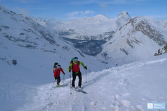
The mountain hut Faneshütte / Rifugio Fanes is located in the Ladin part of South Tyrol. It is easily accessible by ski from the valley parking lot at the Pederü hut. Cozy rooms (1-5 beds) and a communal dormitory (11 beds) are available. The kitchen is known for its quality. There are numerous ski tour opportunities – Cima Dieci, Monte Castello, Col Becchei, and especially Piz Lavarella. For the last tour from the hut, the summit of Ciamin is suitable, from which you can ski down to the Pederü parking lot. The hut is on the route of the Dolomiti Haute Route.
Tours starting from hut
Ski tours around Hut Faneshütte - Rifugio Fanes
- Country
- Italy
- Montains
- Dolomiti
- Open (winter)
- 26.12 - mid April
- Beds
- 66
- Winterraum
- 2 beds, special kee
- Shortening of access (cableway, lift, taxi, snowcat...)
- by snowcat from parking at Rifugio Pederü
- Luggage transport
- yes, by snowcat - must be ordered
- Card Pay
- yes
- Shower
- yes
- Wifi
- yes
- UTM / CH1903 x ("longitude" E/W)
- 33T 27137
- UTM / CH1903 y ("latitude" N/S)
- 5166399
- GPX access to hut (waipoints, track)
- Fanes-Rif_access_skitour.gpx
- GPX access to hut (track only)
- Fanes-Hut_access_TRK.gpx
- GPX all tours from the hut
- RifFanes-RifLavarela_ALL_skitour.gpx
- Map
- Pragser Dolomiten - Dolomiti di Braies, Tabacco 1:25000, Nr. 031 with skitour Cortina Ampezzo, Tabacco 1:25000, Nr. 3 with skitour Alta Badia, Tabacco 1:25000, Nr. 7 with skitour
- Guides
- Skitouren in Dolomiten (de, it - Tappeiner) Skitouren in Südtirol, Band 2 (de, it - Tappeiner) Dolomiten (de, Rother)
- Phone (hut)
- +39 0474 453001
- Phone (valley)
- -
- Cell phone
- +39 348 3900660
- Mobile Signal
- yes
- Web
- rifugiofanes.com
- info@rifugiofanes.com
- Owner of hut
- privat
- Rifugio Fanes
- Reservation
- online
- Online reservation
- rifugiofanes.com
- Start Point
- Pederü Hütte - San Vigilio di Marebbe
- UTM / CH1903 x ("longitude" E/W)
- 33 T 273565
- UTM / CH1903 y ("latitude" N/S)
- 5169234
- Altitude
- 1550 m
- Ascent (height difference)
- 500 m
- Time of Access
- 1,5 - 2 h
- Shortening lift
- no, luggage transport by snowcat from Pederü
- Avalanche danger
- Südtirol Lawinenlagebericht (it, de)
- Weather
- Rif. Lavarella / dolomitesmeteo.it Zehnerspitze 3026 m /meteoblue.com Südtirol Wetterbericht (it, de) Kronplatz (snow-forecast.com) Kronplatz (yr.no - en, no) meteo.it (it) meteoam.it (it) Ostalpen (alpenverein.at ,de) Meteodata (Berg)
- Snow report
- bergfex.it snow-forecast.com schneeradar.de (de) onthesnow.com (en)
- Webcams
- Rif. Fanes Kronplatz Gipfel San Vigilio Kronplatz
- Region
- Kronplatz / Plan de Corones Südtirol Tourism
- Public traffic
- Südtirol Mobil
- Skiresort nearby
- Kronplatz / Plan de Corones Alta Badia Dolomiti Superski
- Other links
- San Vigilio Tourism Alta Badia - Tourism
hut Faneshütte - Rifugio Fanes - Reviews
There are no reviews in this section yet. Click the Add Review button to add first review.
Best ski tours in mountains Dolomiti, Italy
-

Kleine Gaisl - Croda Rossa Piccada 2859 m
Pragser Dolomiten - Dolomiti di Braies Dolomiti Italy
- Length of ascent10,5 km
- ascent1690 m
- duration6-8 h
- Fitness difficulty ♦♦♦♦
- Technical difficulty ♦♦♦◊
Skialpinistická túra na Kleine Gaisl (italsky Croda Rossa Piccada) patří k těm náročnějším. Jak kvůli délce, tak i lavinovému nebezpečí za severních svazích. Členitým terénem přes sedlo Fossesser Ridl. Nejobtížnější je vystoupat na hřeben pod Roten Wand a pak po plochém hřebenu na vrchol. Odměnou je impozantní výhled na celé východní Dolomity i mohutné skály Hohe Gaisl. Z vrcholu je vidět sjezdová linie z Passo Colfiedo. Sjezd kopíruje výstupovou trasu.

-
Croda Ciamin (Day 4 H.R. Dolomiten Südtirol) 1422 m
Lavarella Ücia / Rifugio Lavarella Dolomiti Italy
- Length of ascent2 km
- ascent780 m
- duration5-7 h
- Fitness difficulty ♦♦◊◊
- Technical difficulty ♦♦♦◊
CRODA CIAMIN (Day 4 H.R. Dolomiten Südtirol) is a nice peak available from Lavarella, Fanes and Pederü. The enjoyment is the downhill on the groove Gran Vallon
-

Monte Cristallo - Passo Cristallo 2806 m
Dolomiti d´Ampezzo - Cortina, Cimabanche, Schluderbach Dolomiti Italy
- Length of ascent6,5 km
- ascent1390 m
- duration4-5,5 h
- Fitness difficulty ♦♦♦◊
- Technical difficulty ♦♦♦♦
An challenging tour to the Passo/Forcelle Cristallo is a dream come true for everyone who loves thrilling descents. It begins just above the Schluderbach junction, and the most extensive variant finishes with a descent to Passo Tre Croci. Ascent starts along a shaded, gentle, rocky streambed leading into a grand alpine valley. You exit its narrow confines via a tight corridor through the rocks (on the left, to the north). Afterward, you cross a consistently steep, wide slope heading toward a choke point below the saddle.
Descent: Usually, you follow the same path used for the ascent. A very worthwhile alternative is descending on the south side. First, there’s a very steep section, which often has firn-like snow thanks to the sun. While skiing down the scree slopes, stay to the right, then go between the dwarf pines down to the saddle near Hotel Tre Croci (bus stop).
Best ski tours in Italy by skitour.guru
-

Weisseespitze - Cima del Lago Bianco 3532 m
Langtauferer Tal / Vallelunga - Melag Ötztaler Alpen Italy
- Length of ascent7 km
- ascent1615 m
- duration6-8 h
- Fitness difficulty ♦♦♦♦
- Technical difficulty ♦♦♦◊
Skialpinistická túra na Weisseespitze (italsky Cima del Lago Bianco) je špičkovým i náročným zážitkem. Vychází se z konce údolí Langtauferertal z vesničky Melag. Po snadném úvodu běžkařskou stopou následuje poměrně prudký výstup lavinovým svahem a poté dlouhý traverz. Po mírném svahu severním směrem, pak po zbytcích ledovce Falginfernen na úpatí strmého žlabu. S lyžemi na batohu kousek pod hřeben- skidepot. Na mačkách a s cepínem na vrchol. Ideální výhled na velkolepé ledovcové moře - největší ledovcovou pláň Rakouska. Letecké výhledy na ledovcový skiresort Kaunertal. Sjezdovou trasu si za dobrých podmínek můžete vylepšit najetím do kotle západně od výstupové stopy.
-

Glockhauser 3201 m
Langtauferer Tal / Vallelunga - Melag Ötztaler Alpen Italy
- Length of ascent5,5 km
- ascent1085 m
- duration3-4,5 h
- Fitness difficulty ♦♦◊◊
- Technical difficulty ♦♦◊◊
Skialpinistická túra na Glockhauser není příliš náročná a nabízí vynikající výhledy na západní část Ötztálských Alp - Weißkugel, Bärenbartkögel, Falalbenairspitze atd. Zajímavostí je odlišná trasa výstupu a sjezdu Sjezd jihovýchodně situovaným kotlem Schönkar je zejména při firnu skvělým zážitkem. Pozor na laviny při větším množství nového sněhu.