
 Česky
Česky Deutsch


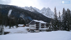

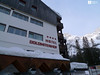
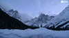
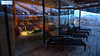
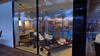
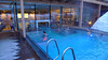
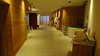

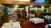

Dolomitenhof is huge five-star hotel in the Fischleintal Valley over Sexten (Moos) with excellent cuisine and great wellness with views of the surrounding mountains. Tours to Hochbrunner Schneid, Oberbachernspitze, Drei Zinnen, Sentinellascharte. A short walk away is the Talschlusshütte chalet. The best starting point for the Sexten Dolomites.
Tours starting from hut
Ski tours around Hut Sextner Dolomiten / Dolomiti Sesto - Dolomitenhof

- Country
- Italy
- Montains
- Dolomiti
- Open (winter)
- December-mid April
- Beds
- 200
- Winterraum
- 0
- Shortening of access (cableway, lift, taxi, snowcat...)
- accessible by car
- UTM / CH1903 x ("longitude" E/W)
- 33 T 297595
- UTM / CH1903 y ("latitude" N/S)
- 5171405
- GPX access to hut (waipoints, track)
- Dolomitenhof-1460-m_WPT.gpx
- GPX all tours from the hut
- SEXTEN-DOLOMITI_all_skitour.gpx
- Map
- Sextener Dolomiten/Dolomiti Sesto, Tabacco 1:25000
- Guides
- Skitouren in Südtirol, Band 2 (de, it - Tappeiner) Skitouren im Hochpustertal (de, it - Tappeiner) Scialpinismo in Dolomiti / Versante Sud, italiano Dolomiten / Rother, deutsch
- Phone (hut)
- +39 0474 713000
- Phone (valley)
- -
- Cell phone
- -
- Mobile Signal
- yes
- Web
- dolomitenhof.com
- info@dolomitenhof.com
- Owner of hut
- Familie Innerkofler
- Hotel Dolomitenhof & Alte Post****
- Start Point
- Moos / Moso - Parkplatz Fischleinboden
- UTM / CH1903 x ("longitude" E/W)
- 33 T 297577
- UTM / CH1903 y ("latitude" N/S)
- 5171526
- Altitude
- 1454 m
- Ascent (height difference)
- 6 m
- Time of Access
- 0,1 h
- Shortening lift
- no
- Avalanche danger
- Südtirol Lawinenlagebericht (it, de)
- Weather
- Südtirol Wetterbericht (it, de) Sexten / snow-forecast.com Sexten / meteo.it (it) Sexten / meteoam.it (it) Sexten / yr.no Ostalpen / alpenverein.at (de) Meteodata (Berg) Elferkofel 3090m / mountain-forecast.com Dreischusterspitze, Cima Tre Scarperi 3151m / mountain-forecast.com
- Snow report
- Sexten / bergfex.it Sexten / snow-forecast.com Sexten / schneeradar.de (de) Sexten / onthesnow.com (en)
- Webcams
- Sexten - Drei Zinnen Blick Sexten Helm Drei Zinnen Hütte Fischleintal
- Region
- Hochpustertal / Val Pusteria Südtirol
- Public traffic
- Südtirol Mobil
- Skiresort nearby
- Sexten / Sesto Dolomiti Superski
hut Sextner Dolomiten / Dolomiti Sesto - Dolomitenhof - Reviews
There are no reviews in this section yet. Click the Add Review button to add first review.
Best ski tours in mountains Dolomiti, Italy
-

Monte Cristallo - Passo Cristallo 2806 m
Dolomiti d´Ampezzo - Cortina, Cimabanche, Schluderbach Dolomiti Italy
- Length of ascent6,5 km
- ascent1390 m
- duration4-5,5 h
- Fitness difficulty ♦♦♦◊
- Technical difficulty ♦♦♦♦
An challenging tour to the Passo/Forcelle Cristallo is a dream come true for everyone who loves thrilling descents. It begins just above the Schluderbach junction, and the most extensive variant finishes with a descent to Passo Tre Croci. Ascent starts along a shaded, gentle, rocky streambed leading into a grand alpine valley. You exit its narrow confines via a tight corridor through the rocks (on the left, to the north). Afterward, you cross a consistently steep, wide slope heading toward a choke point below the saddle.
Descent: Usually, you follow the same path used for the ascent. A very worthwhile alternative is descending on the south side. First, there’s a very steep section, which often has firn-like snow thanks to the sun. While skiing down the scree slopes, stay to the right, then go between the dwarf pines down to the saddle near Hotel Tre Croci (bus stop).

-

Puezspitz (Day 2, H.R. Dolomiten Südtirol) 2913 m
Campill - Pension Odles Dolomiti Italy
- Length of ascent8 km
- ascent1700 m
- duration6,5-8,5 h
- Fitness difficulty ♦♦♦◊
- Technical difficulty ♦♦♦◊
Puezspitze (Dolomites, Puez-Geisler). Ski tour to the distinctive Dolomite peak through the steep corridor between the rocks. Excellent views to the Val Gardena valley and the rocky Sella massif. Split downhill through the Gardenaccia plateau to the Alta Badia area.
-

Seekofel - Croda del Becco 2810 m
Pragser Dolomiten - Dolomiti di Braies Dolomiti Italy
- Length of ascent8 km
- ascent1370 m
- duration5-6,5 h
- Fitness difficulty ♦♦♦◊
- Technical difficulty ♦♦◊◊
Skialpová túra na Seekofel (italsky Croda del Becco) od jezera Pragser Wildsee (Lago di Braies( slibuje velký vyhlídkový zážitek, jak už to bývá u túr v Dolomitech. Nádherné skály lemující jezero a následně výstup údolíčkem a členitým terénem na náhorní plošinu. Následuje odbočka vravo, západním směrem a nad chatou Seekofelhütte do sedla Ofenscharte / Forcella della Forno. Odtud po hřebenu (často vyfoukaný) na vrchol. Letecký pohled na jezero Pragser Wildsee i protější vrchol Kleine Gaisl. V dáli je vidět Tofana i TreCime di Lavaredo. Sjezd po trase výstupu s možností varianty západně od výstupové linie.
Best ski tours in Italy by skitour.guru
-

Glockhauser 3201 m
Langtauferer Tal / Vallelunga - Melag Ötztaler Alpen Italy
- Length of ascent5,5 km
- ascent1085 m
- duration3-4,5 h
- Fitness difficulty ♦♦◊◊
- Technical difficulty ♦♦◊◊
Skialpinistická túra na Glockhauser není příliš náročná a nabízí vynikající výhledy na západní část Ötztálských Alp - Weißkugel, Bärenbartkögel, Falalbenairspitze atd. Zajímavostí je odlišná trasa výstupu a sjezdu Sjezd jihovýchodně situovaným kotlem Schönkar je zejména při firnu skvělým zážitkem. Pozor na laviny při větším množství nového sněhu.
-

Weisseespitze - Cima del Lago Bianco 3532 m
Langtauferer Tal / Vallelunga - Melag Ötztaler Alpen Italy
- Length of ascent7 km
- ascent1615 m
- duration6-8 h
- Fitness difficulty ♦♦♦♦
- Technical difficulty ♦♦♦◊
Skialpinistická túra na Weisseespitze (italsky Cima del Lago Bianco) je špičkovým i náročným zážitkem. Vychází se z konce údolí Langtauferertal z vesničky Melag. Po snadném úvodu běžkařskou stopou následuje poměrně prudký výstup lavinovým svahem a poté dlouhý traverz. Po mírném svahu severním směrem, pak po zbytcích ledovce Falginfernen na úpatí strmého žlabu. S lyžemi na batohu kousek pod hřeben- skidepot. Na mačkách a s cepínem na vrchol. Ideální výhled na velkolepé ledovcové moře - největší ledovcovou pláň Rakouska. Letecké výhledy na ledovcový skiresort Kaunertal. Sjezdovou trasu si za dobrých podmínek můžete vylepšit najetím do kotle západně od výstupové stopy.