
 Česky
Česky Deutsch


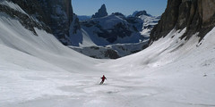
The ski tour to Oberbachernspitze is extremely interesting. From the Fischleintal valley, Talschlusshütte is heading for the wild valley of Rio Fiscalino. Under the monumental mountain Zwölferkogel turn right and climb a narrow gutter to the west. Further progress through the rugged terrain, to the right is the Zsigmondy Hütte. Continue to the right, northwest. The final passage through the steeper slope is not demanding on orientation. From the top a wonderful view to Tre Cime.
Peak
- Country
- Italy
- Montains
- Dolomiti
- Tags
- Dolomiti South Tirol Dolomiti Sesto Fischleintal Italia Italy Sextener Dolomiten
- Hut
- Sextener Dolomiten / Dolomiti Sesto - Sexten, Fischleintal
- UTM / CH1903 x ("longitude" E/W)
- 33T 296826
- UTM / CH1903 y ("latitude" N/S)
- 5168368
Start point
- Start Point
- Sexten - Fischleintal / Talschlusshütte - Rifugio Fondovalle
- Altitude
- 1454 m
- UTM / CH1903 x ("longitude" E/W)
- 33T 297576
- UTM / CH1903 y ("latitude" N/S)
- 5171525
- village, valley
- Sextental / Valle di Sesto
Conditions
- Avalanche danger
- lawinen.report
- Weather
- Moos - Moso / Fischleintal Talschlusshütte - Rifugio Fondovalle, 1548 m Sexten, meteoblue.com Tre Cime Lavaredo 2973m, mountain-forecast.com Sextener Rotwand 2965 m, mountain-forecast.com Zwölferkofel 3094 m, mountain-forecast.com Elferkofel 3092 m, mountain-forecast.com Monte Helmo - Helm 2434 m, mountain-forecast.com Alpenvereinswetter Wetter Südtirol App Wetter Südtirol
- Snow report
- Sexten - Sesto, San Candido - Innichen, 3 Peaks Dolomites, onthesnow.com 3 Zinnen Dolomiten, bergfex.it 3 Zinnen Dolomiten, skiresort.info Tre Cime - Hochpustertal, snow.cz
- Webcams
- Sexten - Fischleintal, all webcams
Ski tour map on Oberbachernspitze / Croda Fiscalina Ovest


 bivakovací nouzová chata
  cepín a mačky potřeba
 exponovaný, obtížný terén
 horská chata
 hôtel, penzion
 lanovka, vlek
 lavinové nebezpečí, svah > 30°
 ledovcové trhliny
 lehká túra
 mimořádně obtížná túra
 mírně obtížná túra
 obtížná túra
 parkoviště
 přístup k chatě
 restaurace
 sedlo
sedlo sjezd
sjezd skidepo
 vrchol
 výstup
 začátek ledovce
- bivouac, winter room
- crampons & ice axe necessary
- exposed, difficulty terrain
- mountain hut, refuge
- hotel, pension
- cableway, skilift
- avalanche danger, slope > 30°
- glacier cracks
- little difficult tour
- extremely difficult tour
- rather difficult tour
- difficult tour
- parking
- hut acces
- restaurant
- col, pass, saddle
- descent
- skidepot
- peak, summit
- ascent
- glacier beginning
- biwak, winterraum
- steigeisen & pickel erforderlich
- ausgesetzt, schwierige gelände
- berghütte
- hotel, pension
- seilbahn, skilift
- lawinengefahr, hangneigung > 30°
- gletscherspalten
- wenig schwierige tour
- äusserst schwierige tour
- ziemlich schwierige tour
- schwierige tour
- parkplatz
- zugang zur hütte
- restaurant
- sattel, joch, pass
- abfahrt
- skidepot
- gipfel
- aufsieg
- gletscher anfang
- bivacco, locale invernale
- ramponi & piccozza necessari
- esposto, terreno difficolt?
- rifugio, capanna
- alberghi, pensione
- funivia, seggiovia
- pericolo di valanghe, pendenza > 30°
- crepe glacier
- tour piccolo difficile
- tour estremamente difficile
- tour piuttosto difficile
- escursioni difficili
- parcheggio
- accesso capanna
- ristorante
- col, sella, passo, forcella
- discesa
- sci deposito
- picco, vertice, piz
- salita
- inizio ghiacciaio
- bivouac, local d'hiver
- crampons & piolet nécessaire
- exposée, difficulté du terrain
- cabane de montagne, refuge
- hôtel, pension
- téléphérique, téléski
- danger d'avalanche, pente > 30°
- crevasse du glacier
- peu difficile tour
- extr?mement difficile tournée
- assez difficile tour
- difficile tournée
- parking
- acces cabane
- restaurant
- col, selle
- descente
- skis dépôt
- pic, sommet
- ascension
- début glacier
- < 20°
- 20° - 25°
- 25° - 30°
- 30° - 35°
- 35° - 40°
- > 40°
Current weather conditions in the tour area
Planning of ski tour
- Fitness difficulty
-
- ♦♦♦◊
- Technical difficulty
-
- ♦♦◊◊
- best time for this tour
- February-March
- Glacier
- No
- Map
- Sextener Dolomitem, Dolomiti di Sesto / Tabacco Nr. 10, 1:25000
- Guides
- Skitouren in Hochpustertal / Tappeiner, deutsch Scialpinismo in Alta Pusteria / Tappeiner, italiano
About Ski tour
- Time difficulty
- Ascent (height difference)
- 1250 m
- Lenght of ascent
- km
- Descent (height difference)
- 1250 m
- Total time of the tour
- h
- Elevation Range
- 1454 - 2677 m
- Principal Aspect
- Soputh, East S-south, N-north, W-west, E-east
Download
- GPX (track only)
- Oberbachernspitze_Moos_TRK.gpx best for display on a detailed topographical map (mapy.cz) or in apps for smartphones (Locus, Garmin Connect, etc.)
- GPX (waipoints, track)
- Oberbachernspitze_Sexten_skitour.gpx great for uploading in GPS device
- KML (with POI)
- Oberbachernspitze_Moos_skitour.kml for viewing in the Google Earth 3D map application, which you can install on your PC
Current avalanche potential on tour - Oberbachernspitze / Croda Fiscalina Ovest

tour Oberbachernspitze / Croda Fiscalina Ovest - Reviews
There are no reviews in this section yet. Click the Add Review button to add first review.
Ski tours around Hut Sextener Dolomiten / Dolomiti Sesto - Sexten, Fischleintal, in mountains Dolomiti, Italy
-
Hochbrunner Schneid / Monte Popera 3046 m
Sextener Dolomiten / Dolomiti Sesto - Sexten, Fischleintal Dolomiti Italy
- Length of ascent7 km
- ascent1592 m
- duration6-8 h
- Fitness difficulty ♦♦♦♦
- Technical difficulty ♦♦♦♦
The most eastern 3000 peak of the Sexten Alps, a great yet challenging ski tour. In the second half of the tour are steep slopes, over 35 °. A great view of Tre Cime from an unusual angle.

-

Sextner Stein / Sasso del Sesto 2539 m
Sextener Dolomiten / Dolomiti Sesto - Sexten, Fischleintal Dolomiti Italy
- Length of ascent8 km
- ascent1370 m
- duration3,5-5 h
- Fitness difficulty ♦♦◊◊
- Technical difficulty ♦♦◊◊
Simple panoramic ski tour with a fantastic view of the monumental Drei Zinnen – the three towers of the Tre Cime di Lavaredo massif – and other beautiful rocky peaks, such as Monte Cristallo. Through the Fischleintal valley, the route leads past the Talschlusshütte / Rifugio Fondovalle, turning right up through the small Altensteintal valley. On the horizon lies the saddle with the Drei Zinnen Hütte / Rifugio Locatelli. Just before the hut, near the chapel, the path leads right to the rocky summit. There is an option to take a detour to the flat viewpoint over the Selletta Bassa ridge (see Google Earth map). The descent follows the ascent route.
Best ski tours in Dolomiti by skitour.guru
-
Croda Ciamin (Day 4 H.R. Dolomiten Südtirol) 1422 m
Lavarella Ücia / Rifugio Lavarella Dolomiti Italy
- Length of ascent2 km
- ascent780 m
- duration5-7 h
- Fitness difficulty ♦♦◊◊
- Technical difficulty ♦♦♦◊
CRODA CIAMIN (Day 4 H.R. Dolomiten Südtirol) is a nice peak available from Lavarella, Fanes and Pederü. The enjoyment is the downhill on the groove Gran Vallon
-

Seekofel - Croda del Becco 2810 m
Pragser Dolomiten - Dolomiti di Braies Dolomiti Italy
- Length of ascent8 km
- ascent1370 m
- duration5-6,5 h
- Fitness difficulty ♦♦♦◊
- Technical difficulty ♦♦◊◊
Skialpová túra na Seekofel (italsky Croda del Becco) od jezera Pragser Wildsee (Lago di Braies( slibuje velký vyhlídkový zážitek, jak už to bývá u túr v Dolomitech. Nádherné skály lemující jezero a následně výstup údolíčkem a členitým terénem na náhorní plošinu. Následuje odbočka vravo, západním směrem a nad chatou Seekofelhütte do sedla Ofenscharte / Forcella della Forno. Odtud po hřebenu (často vyfoukaný) na vrchol. Letecký pohled na jezero Pragser Wildsee i protější vrchol Kleine Gaisl. V dáli je vidět Tofana i TreCime di Lavaredo. Sjezd po trase výstupu s možností varianty západně od výstupové linie.
-

Kleine Gaisl - Croda Rossa Piccada 2859 m
Pragser Dolomiten - Dolomiti di Braies Dolomiti Italy
- Length of ascent10,5 km
- ascent1690 m
- duration6-8 h
- Fitness difficulty ♦♦♦♦
- Technical difficulty ♦♦♦◊
Skialpinistická túra na Kleine Gaisl (italsky Croda Rossa Piccada) patří k těm náročnějším. Jak kvůli délce, tak i lavinovému nebezpečí za severních svazích. Členitým terénem přes sedlo Fossesser Ridl. Nejobtížnější je vystoupat na hřeben pod Roten Wand a pak po plochém hřebenu na vrchol. Odměnou je impozantní výhled na celé východní Dolomity i mohutné skály Hohe Gaisl. Z vrcholu je vidět sjezdová linie z Passo Colfiedo. Sjezd kopíruje výstupovou trasu.