
 Česky
Česky Deutsch


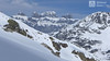
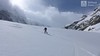
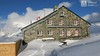
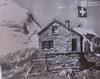
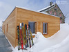

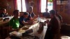

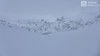
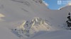

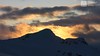
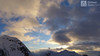
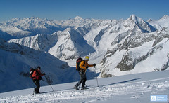
Tierberglihütte is classical mountain hut, situated high above the Gadmental valley above the Stingletscher glacier. Excellent location for skitours to the peaks of Sustenhorn, Gwächtenhorn, Hint. Tierberg. A haven for ski mountaineers at the Urner Haute Route and Swiss Glacier Haute Route. Also renowned for the 1400 hm downhill on the Zwischen Tierbergen glacier. After complete reconstruction in 2015, extended by beautiful space on the north side of the cottage. Beautiful sunsets, Jungfrau beer and great goodies and service.
Tours starting from hut
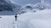
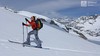
Ski tours around Hut Tierberglihütte
-

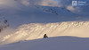
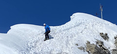
Sustenhorn (day 1, h.r. Swiss Glacier) 3503 m
Tierberglihütte Urner Alps Switzerland
- Length of ascent4,4 km
- ascent1640 m
- duration6-8 h
- Fitness difficulty ♦♦♦◊
- Technical difficulty ♦♦◊◊
A very popular tour of glacial terrain. Start at Hotel Steingletscher (Sustenpass road, parking) or Tierbergli hütte. From the parking a large elevation of 1700 m. Technically not very demanding tour, but conditionally yes. Route parameters are listed at the start of the Hotel Steingletscher and from the peak of Sustenhorn leads downhill to Tierbergli.

-
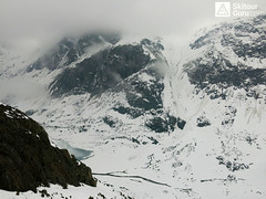
Zwischen Tierbergen, day 2, h.r. Swiss Glacie 2975 m
Tierberglihütte Urner Alps Switzerland
- Length of ascent10 km
- ascent1390 m
- duration7-9 h
- Fitness difficulty ♦♦♦♦
- Technical difficulty ♦♦♦◊
Tierberglücke & Sacklimi, these are two saddles between huts. If not ideal conditions, it is a very difficult tour. The Tierberglücke saddle waits for a 1300 m steep downhill ride on the western slope of the Zwischen Tierbergen glacier. Locally challenging and avalanche. After crossing the creek from Triftgletscher, a very difficult ascent takes place through a narrow corridor, often turning every 5 meters. There follows a wide crest that rises to Sacklimi saddle. In the ascent finish to Sacklimi is route steep and there is a avalanche risk. The downhill is easy and the final ascent to the Trift Hut also.
- Country
- Switzerland
- Montains
- Urner Alps
- Open (winter)
- march on weekends, april-may
- Beds
- 70
- Winterraum
- 0
- Shortening of access (cableway, lift, taxi, snowcat...)
- no
- UTM / CH1903 x ("longitude" E/W)
- 674630
- UTM / CH1903 y ("latitude" N/S)
- 172790
- GPX access to hut (waipoints, track)
- TierbergliHuette Access SKITOURGURUcom.gpx
- GPX all tours from the hut
- TierbergliHut allTOUR_WPT_SkitourGuru.gpx
- Map
- Sustenpass 255 S, Swisstopo 1:50000 Meiental 1211, Swisstopo 1:25000
- Guides
- Alpine Skitouren Zentralschweiz – Tessin", SAC Verlag Zentralschweizer Voralpen und Alpen Die klassischen Skitouren (SAC, deutsch) Les classiques de randonnée à ski (SAC, francais) Scialpinismo in Svizzera Zentralschweiz (Rother, deutsch)
- Phone (hut)
- +41 (0)79 363 25 70
- Phone (valley)
- +41 (0)79 342 66 77
- Cell phone
- -
- Web
- www.tierbergli.ch
- info@tierbergli.ch
- Owner of hut
- SAC Baselland
- Tierberglihütte
- Start Point
- Hotel Steingletscher
- UTM / CH1903 x ("longitude" E/W)
- 675573
- UTM / CH1903 y ("latitude" N/S)
- 175994
- Altitude
- 1864 m
- Ascent (height difference)
- 930 m
- Time of Access
- 3-4 h
- Shortening lift
- no
- Avalanche danger
- SLF
- Weather
- SRF Meteo Meteoschweiz snow-forecast.com - Engelberg Meteoblue - Tierberglihütte yr.no - Tierberglihütte
- Snow report
- snow-forecast.com - Engelberg snow-forecast.com - Andermatt bergfex.ch - Engelberg bergfex.ch - Andermatt onthesnow.com skiresort.info Melchsee-Frutt snow.myswitzerland.com Melchsee-Frutt
- Webcams
- Steingletcher Engelberg - Titlis Andermatt
- Region
- Haslital Zentralschweiz Tourismus
- Public traffic
- Vlaky Linkové autobusy
- Skiresort nearby
- Engelberg Melchsee-Frutt Andermatt
- Other links
- Hotel Steingletscher Haslital Hütten
hut Tierberglihütte - Reviews
michal.bulicka 25. 02. 2021
- Staff ♦♦♦◊
- Food ♦♦♦◊
- Overnight room ♦♦♦◊
- Overnight lager ♦♦♦◊
- Cosiness ♦♦◊◊
- Overall rating ♦♦♦◊
Best ski tours in mountains Urner Alps, Switzerland
-

Chli Bielenhorn 2940 m
Andermatt - Realp - Oberalppass Urner Alps Switzerland
- Length of ascent8,5 km
- ascent1450 m
- duration5-6,5 h
- Fitness difficulty ♦♦♦◊
- Technical difficulty ♦♦◊◊
Chli Bielenhorn je skalnatá špička v říši monumentálních žulových stěn divokých hor. Začátek kolem silnice na Furkapass pokračuje po pláni pod chatou Albert-Heim-Hütte. Pak přichází v sousedství pohled na ledovce monumentálního Dammastocku. V kulisách skal vede logická linie ke skidepu kousek pod vrcholem. V případě stabilního sněhu je fajn alternativou sjezdová linie jižně od výstupové stopy a dále členitým terénem k hotelu Tiefenbach a v okolí silnice nebo po ní zpět do Realpu.
-

Pazolastock - Piz Badus 2928 m
Andermatt - Realp - Oberalppass Urner Alps Switzerland
- Length of ascent6 km
- ascent1370 m
- duration4-6 h
- Fitness difficulty ♦♦◊◊
- Technical difficulty ♦♦◊◊
Vyhlídková, poměrně jednoduchá túra po hřebeni na Piz Badus přes Pazolastock. Na start túry je snadná cesta vlakem z Andermattu. Pozor na laviny při traverzu Pazolastocku. První sjezd je lehký a bezpečný. Logická výstupová linie přes hřeben pod Piz Badus. Na vrchol v mačkách nebo na lyžích, podle podmínek. Letecký pohled na Andermatt. Při sjezdu z Piz Badus pozor na strmý úsek za jezerem. Po nalepení pásů závěrečných 100 výškových metrů do sedla Oberalppass k vlaku (jezdí každou hodinu).
-
Pizzo Lucendro 2963 m
Rotondohütte Urner Alps Switzerland
- Length of ascent5,5 km
- ascent1090 m
- duration4-6 h
- Fitness difficulty ♦♦◊◊
- Technical difficulty ♦♦♦◊
Pizzo Lucendro je výrazný vrchol nad Gotthardpassem a také prvotřídní rozhledna. Na túru lze vyrazit z údolního Realpu, snazší je start z chaty Rotondohütte. Po sjezdu nad úroveň salaší nastává dlouhý výstup členitým terénem, který nabírá na strmosti. Těsně pod skalním sedlem je v úzkém koridoru zvládání otočky nutností. Za sedlem následuje poměrně snadný výstup do sedla, k místu, kde bývá depo lyží. Při výstupu po hřebeni k vrcholovému kříži pozor na převěje a místy exponovaný terén. Při sjezdu za jarního firnu se vyplatí počkat v sedle, než slunce změkčí stinný svah pro velkolepý odpolední sjezd západním svahem. Z nejnižšího bodu návrat na chatu nebo sjezd až do Realpu.
Best ski tours in Switzerland by skitour.guru
-

Fenetre Ferret - H.R. Grande Lui, Day 3 2698 m
La Fouly Walliser Alpen / Alpes valaisannes Switzerland
- Length of ascent11 km
- ascent1330 m
- duration5-7 h
- Fitness difficulty ♦♦♦◊
- Technical difficulty ♦♦◊◊
The Haute Route Grande Lui variant from Chamonix to Zermatt, also known as the "Haute Route Pure", leads from La Fouly to the Grand Saint Bernard Pass. Overnight accommodation is provided in the hospice of the same name, under conditions similar to those in a mountain hut. The traverse of the slope below the Ferret lakes is particularly prone to avalanches.
-

Tour du Ciel - day 3 3649 m
Cabane du Mountet Walliser Alpen / Alpes valaisannes Switzerland
- Length of ascent10,5 km
- ascent2420 m
- duration10-12 h
- Fitness difficulty ♦♦♦♦
- Technical difficulty ♦♦♦♦
A very long and demanding, royal stage of this Haute Route. In my opinion, the most impressive stage of all multi-day Alpine crossings. Due to the elevation gain and time required, it’s worth considering splitting the stage into two days with an overnight stay in Zinal. The long, exposed ridge to the summit requires rope protection depending on conditions. The descent is fantastically long, but caution is needed – there are large crevasses. This ski tour is only recommended in stable weather; in poor conditions, it’s advisable to bypass the Blanc de Moming via the Glacier de Zinal and ascend directly to the Cabane de Tracuit.
-
Grosser Aletschhorn 4189 m
Oberaletschhütte Berner Alpen / Alpes bernoises Switzerland
- Length of ascent7 km
- ascent1750 m
- duration7-9 h
- Fitness difficulty ♦♦♦♦
- Technical difficulty ♦♦♦◊
Grosser Aletschhorn is lonely 4000 in the middle of the Berner Alps in Switzerland over the Oberaletschgletscher and the hut of the same name. From the top views of the Wallis Alps, including the Matterhorn.