
 Česky
Česky Deutsch


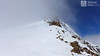
 Urner Alps Switzerland photo 01")
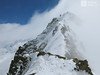
 Urner Alps Switzerland photo 02")
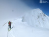
 Urner Alps Switzerland photo 03")
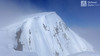
 Urner Alps Switzerland photo 04")
 Urner Alps Switzerland photo 05")
 Urner Alps Switzerland photo 06")
 Urner Alps Switzerland photo 07")
 Urner Alps Switzerland photo 08")
 Urner Alps Switzerland photo 09")
 Urner Alps Switzerland photo 10")
 Urner Alps Switzerland photo 11")
 Urner Alps Switzerland photo 12")
 Urner Alps Switzerland photo 13")
 Urner Alps Switzerland photo 14")
 Urner Alps Switzerland photo 15")
 Urner Alps Switzerland photo 16")
 Urner Alps Switzerland photo 17")
 Urner Alps Switzerland photo 18")
 Urner Alps Switzerland photo 19")
 Urner Alps Switzerland photo 20")
 Urner Alps Switzerland photo 21")
 Urner Alps Switzerland photo 22")
 Urner Alps Switzerland photo 23")
 Urner Alps Switzerland photo 24")
 Urner Alps Switzerland photo 25")
 Urner Alps Switzerland photo 26")
 Urner Alps Switzerland photo 27")


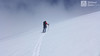

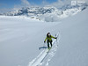
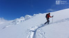
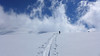
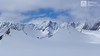


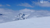
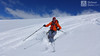
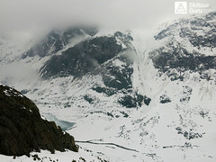
A very popular tour of glacial terrain. Start at Hotel Steingletscher (Sustenpass road, parking) or Tierbergli hütte. From the parking a large elevation of 1700 m. Technically not very demanding tour, but conditionally yes. Route parameters are listed at the start of the Hotel Steingletscher and from the peak of Sustenhorn leads downhill to Tierbergli.
Peak
- Country
- Switzerland
- Montains
- Urner Alps
- Tags
- Haute Route Swiss Glacier Tierberglihütte Urner Alpen
- Hut
- Tierberglihütte
- UTM / CH1903 x ("longitude" E/W)
- 677747
- UTM / CH1903 y ("latitude" N/S)
- 172462
Start point
- Start Point
- Tierberglihütte
- Altitude
- 1864 m
- UTM / CH1903 x ("longitude" E/W)
- 674630
- UTM / CH1903 y ("latitude" N/S)
- 172790
- village, valley
- Hotel Steingletscher 1864 m
- cableway / lift
- no
Conditions
- Avalanche danger
- SLF
- Weather
- SRF Meteo Meteoschweiz snow-forecast.com - Engelberg Meteoblue - Tierberglihütte yr.no - Tierberglihütte
- Snow report
- snow-forecast.com - Engelberg snow-forecast.com - Andermatt bergfex.ch - Engelberg bergfex.ch - Andermatt onthesnow.com skiresort.info Melchsee-Frutt snow.myswitzerland.com Melchsee-Frutt
- Webcams
- Steingletcher Engelberg - Titlis Andermatt
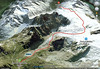
Ski tour map on Sustenhorn (day 1, h.r. Swiss Glacier)


 bivakovací nouzová chata
  cepín a mačky potřeba
 exponovaný, obtížný terén
 horská chata
 hôtel, penzion
 lanovka, vlek
 lavinové nebezpečí, svah > 30°
 ledovcové trhliny
 lehká túra
 mimořádně obtížná túra
 mírně obtížná túra
 obtížná túra
 parkoviště
 přístup k chatě
 restaurace
 sedlo
sedlo sjezd
sjezd skidepo
 vrchol
 výstup
 začátek ledovce
- bivouac, winter room
- crampons & ice axe necessary
- exposed, difficulty terrain
- mountain hut, refuge
- hotel, pension
- cableway, skilift
- avalanche danger, slope > 30°
- glacier cracks
- little difficult tour
- extremely difficult tour
- rather difficult tour
- difficult tour
- parking
- hut acces
- restaurant
- col, pass, saddle
- descent
- skidepot
- peak, summit
- ascent
- glacier beginning
- biwak, winterraum
- steigeisen & pickel erforderlich
- ausgesetzt, schwierige gelände
- berghütte
- hotel, pension
- seilbahn, skilift
- lawinengefahr, hangneigung > 30°
- gletscherspalten
- wenig schwierige tour
- äusserst schwierige tour
- ziemlich schwierige tour
- schwierige tour
- parkplatz
- zugang zur hütte
- restaurant
- sattel, joch, pass
- abfahrt
- skidepot
- gipfel
- aufsieg
- gletscher anfang
- bivacco, locale invernale
- ramponi & piccozza necessari
- esposto, terreno difficolt?
- rifugio, capanna
- alberghi, pensione
- funivia, seggiovia
- pericolo di valanghe, pendenza > 30°
- crepe glacier
- tour piccolo difficile
- tour estremamente difficile
- tour piuttosto difficile
- escursioni difficili
- parcheggio
- accesso capanna
- ristorante
- col, sella, passo, forcella
- discesa
- sci deposito
- picco, vertice, piz
- salita
- inizio ghiacciaio
- bivouac, local d'hiver
- crampons & piolet nécessaire
- exposée, difficulté du terrain
- cabane de montagne, refuge
- hôtel, pension
- téléphérique, téléski
- danger d'avalanche, pente > 30°
- crevasse du glacier
- peu difficile tour
- extr?mement difficile tournée
- assez difficile tour
- difficile tournée
- parking
- acces cabane
- restaurant
- col, selle
- descente
- skis dépôt
- pic, sommet
- ascension
- début glacier
- < 20°
- 20° - 25°
- 25° - 30°
- 30° - 35°
- 35° - 40°
- > 40°
Current weather conditions in the tour area
Planning of ski tour
- Fitness difficulty
-
- ♦♦♦◊
- Technical difficulty
-
- ♦♦◊◊
- best time for this tour
- March-May
- Glacier
- Yes
- Map
- Sustenpass 255 S, Swisstopo 1:50000 Meiental 1211, Swisstopo 1:25000
- Guides
- Alpine Skitouren Zentralschweiz – Tessin", SAC Verlag Die klassischen Skitouren (SAC, deutsch) Les classiques de randonnée à ski (SAC, francais) Scialpinismo in Svizzera Zentralschweiz (Rother, deutsch)
- find current conditions and experiences on the spot
- gipfelbuch.ch
About Ski tour
- Time difficulty
- Ascent (height difference)
- 1640 m
- Lenght of ascent
- 4,4 km
- Descent (height difference)
- 740 m
- Total Lenght of tour
- 8,8 km
- Total time of the tour
- 6-8 h
- Elevation Range
- 1865 - 3503 m
- Principal Aspect
- NW, W, SSW S-south, N-north, W-west, E-east
Download
- GPX (track only)
- Sustenhorn_Steingletscher_TierbergliH_TRACK.gpx best for display on a detailed topographical map (mapy.cz) or in apps for smartphones (Locus, Garmin Connect, etc.)
- GPX (waipoints, track)
- Sustenhorn_Day1_SwissGlacier_SKITOURGURUcom.gpx great for uploading in GPS device
- KML (with POI)
- Sustenhorn TOUR SKItourGURU.kml for viewing in the Google Earth 3D map application, which you can install on your PC
Current avalanche potential on tour - Sustenhorn (day 1, h.r. Swiss Glacier)

tour Sustenhorn (day 1, h.r. Swiss Glacier) - Reviews
There are no reviews in this section yet. Click the Add Review button to add first review.
Ski tours around Hut Tierberglihütte, in mountains Urner Alps, Switzerland
Best ski tours in Urner Alps by skitour.guru
-

Pazolastock - Piz Badus 2928 m
Andermatt - Realp - Oberalppass Urner Alps Switzerland
- Length of ascent6 km
- ascent1370 m
- duration4-6 h
- Fitness difficulty ♦♦◊◊
- Technical difficulty ♦♦◊◊
Vyhlídková, poměrně jednoduchá túra po hřebeni na Piz Badus přes Pazolastock. Na start túry je snadná cesta vlakem z Andermattu. Pozor na laviny při traverzu Pazolastocku. První sjezd je lehký a bezpečný. Logická výstupová linie přes hřeben pod Piz Badus. Na vrchol v mačkách nebo na lyžích, podle podmínek. Letecký pohled na Andermatt. Při sjezdu z Piz Badus pozor na strmý úsek za jezerem. Po nalepení pásů závěrečných 100 výškových metrů do sedla Oberalppass k vlaku (jezdí každou hodinu).

-

Chli Bielenhorn 2940 m
Andermatt - Realp - Oberalppass Urner Alps Switzerland
- Length of ascent8,5 km
- ascent1450 m
- duration5-6,5 h
- Fitness difficulty ♦♦♦◊
- Technical difficulty ♦♦◊◊
Chli Bielenhorn je skalnatá špička v říši monumentálních žulových stěn divokých hor. Začátek kolem silnice na Furkapass pokračuje po pláni pod chatou Albert-Heim-Hütte. Pak přichází v sousedství pohled na ledovce monumentálního Dammastocku. V kulisách skal vede logická linie ke skidepu kousek pod vrcholem. V případě stabilního sněhu je fajn alternativou sjezdová linie jižně od výstupové stopy a dále členitým terénem k hotelu Tiefenbach a v okolí silnice nebo po ní zpět do Realpu.
-

Diechterhorn (day 3, h.r. Swiss Glacier) 3389 m
Trifthütte Urner Alps Switzerland
- Length of ascent12 km
- ascent2100 m
- duration10-12 h
- Fitness difficulty ♦♦♦♦
- Technical difficulty ♦♦♦♦
Hiking on top of fantastic lookout tower. Glacier skitour. At the end, you will reach the summit from the north, to the top of the climbing terrain. Next continue to the Diechterlimi saddle and from there a fantastic downhill run to Gelmerhütte and then to the Gelmersee dam. If the lake is not frozen, the route along the northern bank can be very challenging, depending on the snow conditions. After crossing the dam, is coming downhill, often very complicated, traversing western slope to the Grimselpass road. After that, a bit on the parking lot under the Räterichsboden dam and at first a steep traverse to Bächlihütte - a hut on the top.