
 Česky
Česky Deutsch


Andermatt is a ski resort in the heart of Switzerland and a transportation hub between the Oberalppass, Furkapass, and Gotthardpass passes. Access to the tours is available by train or car. There is a wide range of accommodation options in Andermatt.
Tours starting from hut
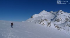
Ski tours around Hut Andermatt - Realp - Oberalppass
-

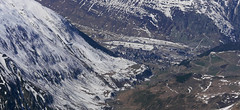
Chli Bielenhorn 2940 m
Andermatt - Realp - Oberalppass Urner Alps Switzerland
- Length of ascent8,5 km
- ascent1450 m
- duration5-6,5 h
- Fitness difficulty ♦♦♦◊
- Technical difficulty ♦♦◊◊
Chli Bielenhorn je skalnatá špička v říši monumentálních žulových stěn divokých hor. Začátek kolem silnice na Furkapass pokračuje po pláni pod chatou Albert-Heim-Hütte. Pak přichází v sousedství pohled na ledovce monumentálního Dammastocku. V kulisách skal vede logická linie ke skidepu kousek pod vrcholem. V případě stabilního sněhu je fajn alternativou sjezdová linie jižně od výstupové stopy a dále členitým terénem k hotelu Tiefenbach a v okolí silnice nebo po ní zpět do Realpu.

-

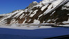
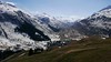
Pazolastock - Piz Badus 2928 m
Andermatt - Realp - Oberalppass Urner Alps Switzerland
- Length of ascent6 km
- ascent1370 m
- duration4-6 h
- Fitness difficulty ♦♦◊◊
- Technical difficulty ♦♦◊◊
Vyhlídková, poměrně jednoduchá túra po hřebeni na Piz Badus přes Pazolastock. Na start túry je snadná cesta vlakem z Andermattu. Pozor na laviny při traverzu Pazolastocku. První sjezd je lehký a bezpečný. Logická výstupová linie přes hřeben pod Piz Badus. Na vrchol v mačkách nebo na lyžích, podle podmínek. Letecký pohled na Andermatt. Při sjezdu z Piz Badus pozor na strmý úsek za jezerem. Po nalepení pásů závěrečných 100 výškových metrů do sedla Oberalppass k vlaku (jezdí každou hodinu).
- Country
- Switzerland
- Montains
- Urner Alps
- Open (winter)
- Beds
- 0
- Winterraum
- Shortening of access (cableway, lift, taxi, snowcat...)
- UTM / CH1903 x ("longitude" E/W)
- UTM / CH1903 y ("latitude" N/S)
- GPX all tours from the hut
- Andermatt_skitours.gpx
- Map
- Sustenpass 255 S, Swisstopo 1:50000 Nufenenpass 265 S, Swisstopo 1:50000 Disentis/Mustér 256 S, Swisstopo 1:50000 Valle Leventina 266 S, Swisstopo 1:50000
- Guides
- Alpine Skitouren Zentralschweiz – Tessin", SAC Verlag Zentralschweizer Voralpen und Alpen Die klassischen Skitouren (SAC, deutsch) Les classiques de randonnée à ski (SAC, francais) Scialpinismo in Svizzera (SAC, italiano) Zentralschweiz (Rother, deutsch)
- Phone (hut)
- -
- Phone (valley)
- -
- Cell phone
- -
- Web
- -
- -
- Owner of hut
- -
- Avalanche danger
- SLF
- Weather
- SRF Meteo Meteoschweiz Andermatt, snow-forecast.com Andermatt - Meteoblue Oberalppass - Meteoblue Furkapass - Meteoblue Gotthardpass - Meteoblue Pazolastock - Meteoblue Chli Bielenhorn - Meteoblue Andermatt, yr.no
- Snow report
- Switzerland snow report Andermatt Snow Forecast
- Webcams
- Andermatt - all webcams
- Region
- Andermatt Zentralschweiz - deutsch Uri - kanton Realp
- Public traffic
- Train - sbb.ch Bus - postauto.ch Alpenpässe - průsmyky, průjezdnost
- Skiresort nearby
- Andermatt - Sedrun - Disentis
- Other links
- Schweiz Tourismus
hut Andermatt - Realp - Oberalppass - Reviews
There are no reviews in this section yet. Click the Add Review button to add first review.
Best ski tours in mountains Urner Alps, Switzerland
-

Diechterhorn (day 3, h.r. Swiss Glacier) 3389 m
Trifthütte Urner Alps Switzerland
- Length of ascent12 km
- ascent2100 m
- duration10-12 h
- Fitness difficulty ♦♦♦♦
- Technical difficulty ♦♦♦♦
Hiking on top of fantastic lookout tower. Glacier skitour. At the end, you will reach the summit from the north, to the top of the climbing terrain. Next continue to the Diechterlimi saddle and from there a fantastic downhill run to Gelmerhütte and then to the Gelmersee dam. If the lake is not frozen, the route along the northern bank can be very challenging, depending on the snow conditions. After crossing the dam, is coming downhill, often very complicated, traversing western slope to the Grimselpass road. After that, a bit on the parking lot under the Räterichsboden dam and at first a steep traverse to Bächlihütte - a hut on the top.
-
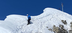
Pizzo Lucendro 2963 m
Rotondohütte Urner Alps Switzerland
- Length of ascent5,5 km
- ascent1090 m
- duration4-6 h
- Fitness difficulty ♦♦◊◊
- Technical difficulty ♦♦♦◊
Pizzo Lucendro je výrazný vrchol nad Gotthardpassem a také prvotřídní rozhledna. Na túru lze vyrazit z údolního Realpu, snazší je start z chaty Rotondohütte. Po sjezdu nad úroveň salaší nastává dlouhý výstup členitým terénem, který nabírá na strmosti. Těsně pod skalním sedlem je v úzkém koridoru zvládání otočky nutností. Za sedlem následuje poměrně snadný výstup do sedla, k místu, kde bývá depo lyží. Při výstupu po hřebeni k vrcholovému kříži pozor na převěje a místy exponovaný terén. Při sjezdu za jarního firnu se vyplatí počkat v sedle, než slunce změkčí stinný svah pro velkolepý odpolední sjezd západním svahem. Z nejnižšího bodu návrat na chatu nebo sjezd až do Realpu.
-

Sustenhorn (day 1, h.r. Swiss Glacier) 3503 m
Tierberglihütte Urner Alps Switzerland
- Length of ascent4,4 km
- ascent1640 m
- duration6-8 h
- Fitness difficulty ♦♦♦◊
- Technical difficulty ♦♦◊◊
A very popular tour of glacial terrain. Start at Hotel Steingletscher (Sustenpass road, parking) or Tierbergli hütte. From the parking a large elevation of 1700 m. Technically not very demanding tour, but conditionally yes. Route parameters are listed at the start of the Hotel Steingletscher and from the peak of Sustenhorn leads downhill to Tierbergli.
Best ski tours in Switzerland by skitour.guru
-
Piz Calderas 3397 m
Chamanna Jenatsch / Jenatschhütte Albula Alps Switzerland
- Length of ascent km
- ascent745 m
- duration2,5-4 h
- Fitness difficulty ♦♦◊◊
- Technical difficulty ♦♦♦◊
Piz Calderas is a popular peak above Chamanna Jenatsch. From the valley above the hut turn left onto the northern slope of the glacier Vadret Calderas. Followed by travers to the glacial mulch and at the end of the southeast slope to the top. Downhill along the exit route.
-

Vordere/ Hintere Jamspitze SW 3155 m
Tuoi Chamonna / Tuoihütte Silvretta Switzerland
- Length of ascent km
- ascent910 m
- duration3-4 h
- Fitness difficulty ♦♦◊◊
- Technical difficulty ♦♦◊◊
-

Alphubel 4206 m
Britannia Hütte Walliser Alpen / Alpes valaisannes Switzerland
- Length of ascent10 km
- ascent1450 m
- duration7-10 h
- Fitness difficulty ♦♦♦◊
- Technical difficulty ♦♦♦◊
ALPHUBEL (Britannia Hütte, Walliser Alpen) is seemingly lighter 4000vka, but over are dangerous glacial cracks. Ski alpinists can also go from the Saas Fee ski area, most not far from the cable car station Langfluh .