
 Česky
Česky Deutsch


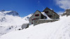


Rotondohütte je chata na pomezí kantonů Uri a Ticino. Start několika túr - Witenwasserenstock, Leckihorn, Pizzo Rotondo, Rottalihorn a Pizzo Lucendro. Zrekonstruovaná moderní chata s několika hromadnými ložnicemi a velkou terasou.
Tours starting from hut
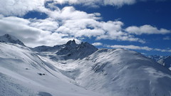
Ski tours around Hut Rotondohütte
-
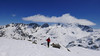
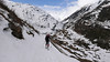
Gross Leckihorn 3068 m
Rotondohütte Urner Alps Switzerland
- Length of ascent3 km
- ascent500 m
- duration2-3 h
- Fitness difficulty ♦♦◊◊
- Technical difficulty ♦♦♦◊
Ideální túra pro první den na chatě. Po výstupu na chatu se dá zvládnout výstup na Leckihorn. Ze sedla výstup v mačkách na vrchol. Krásné výhledy na všechny okolní kopce, zejména Pizzo Rotondo.

-

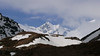
Witenwasserenstock 3082 m
Rotondohütte Urner Alps Switzerland
- Length of ascent3,5 km
- ascent500 m
- duration2-3 h
- Fitness difficulty ♦♦◊◊
- Technical difficulty ♦♦♦◊
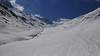
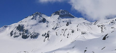
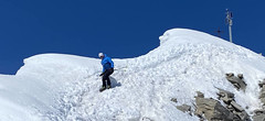
Witenwasserenstock je monumentální hřebenový vrchol mezi chatou Rotondohütte a výraznou věží Pizzo Rotondo. Túpra, která nabízí jednu z možností pro poslední den na chatě a následný sjezd až do Realpu. Po ledovci se dojde na začátek skalnatého terénu a po vystoupání na hřeben odložte lyže ve skidepotu. V mačách a s cepínem poměrně snadný terénem bez výrazné expozice až na lyžařský vrchol - k ocelovému symbolu rozvodí 3 moří. Následný výstup na špici ostrého hřebenu je vzdušným zážitkem a je jen pro ty, kdo netrpí závratí a jsou si jistí v lezeckém terénu.
-
Pizzo Lucendro 2963 m
Rotondohütte Urner Alps Switzerland
- Length of ascent5,5 km
- ascent1090 m
- duration4-6 h
- Fitness difficulty ♦♦◊◊
- Technical difficulty ♦♦♦◊
Pizzo Lucendro je výrazný vrchol nad Gotthardpassem a také prvotřídní rozhledna. Na túru lze vyrazit z údolního Realpu, snazší je start z chaty Rotondohütte. Po sjezdu nad úroveň salaší nastává dlouhý výstup členitým terénem, který nabírá na strmosti. Těsně pod skalním sedlem je v úzkém koridoru zvládání otočky nutností. Za sedlem následuje poměrně snadný výstup do sedla, k místu, kde bývá depo lyží. Při výstupu po hřebeni k vrcholovému kříži pozor na převěje a místy exponovaný terén. Při sjezdu za jarního firnu se vyplatí počkat v sedle, než slunce změkčí stinný svah pro velkolepý odpolední sjezd západním svahem. Z nejnižšího bodu návrat na chatu nebo sjezd až do Realpu.
- Country
- Switzerland
- Montains
- Urner Alps
- Open (winter)
- end december - start may
- Beds
- 85
- Winterraum
- open, 20 beds
- Shortening of access (cableway, lift, taxi, snowcat...)
- no
- Luggage transport
- no
- Card Pay
- yes
- Shower
- yes
- Wifi
- no
- UTM / CH1903 x ("longitude" E/W)
- 680208
- UTM / CH1903 y ("latitude" N/S)
- 155379
- GPX access to hut (waipoints, track)
- RotondoHUt_access_Realp.gpx
- GPX access to hut (track only)
- RotondoHut_access.gpx
- GPX all tours from the hut
- RotondoHut_skitours.gpx
- Map
- Sustenpass 255 S, Swisstopo 1:50000 Nufenenpass 265 S, Swisstopo 1:50000 Valle Leventina 266 S, Swisstopo 1:50000
- Guides
- Alpine Skitouren Zentralschweiz – Tessin", SAC Verlag Zentralschweizer Voralpen und Alpen Die klassischen Skitouren (SAC, deutsch) Les classiques de randonnée à ski (SAC, francais) Scialpinismo in Svizzera (SAC, italiano) Zentralschweiz (Rother, deutsch)
- Phone (hut)
- +41 41 887 16 16
- Phone (valley)
- +41 79 774 24 20
- Cell phone
- -
- Mobile Signal
- no
- Web
- rotondohuette.ch
- info@rotondohuette.ch
- Owner of hut
- SAC - Schweizer Alpenclub
- Rotondohütte
- Reservation
- online
- Online reservation
- alpsonline.org
- Start Point
- Realp - parking nearby train station
- UTM / CH1903 x ("longitude" E/W)
- 681501
- UTM / CH1903 y ("latitude" N/S)
- 161090
- Altitude
- 1550 m
- Ascent (height difference)
- 1020 m
- Time of Access
- 4-5 h
- Shortening lift
- no
- Avalanche danger
- SLF
- Weather
- SRF Meteo Andermatt, snow-forecast.com Andermatt - Meteoblue Oberalppass - Meteoblue Furkapass - Meteoblue Gotthardpass - Meteoblue Pazolastock - Meteoblue Chli Bielenhorn - Meteoblue Andermatt, yr.no Meteoschweiz
- Snow report
- Switzerland snow report Andermatt Snow Forecast
- Webcams
- Andermatt - all webcams
- Region
- Andermatt Zentralschweiz - deutsch Uri - kanton Realp
- Public traffic
- Train - sbb.ch Bus - postauto.ch Alpenpässe - průsmyky, průjezdnost
- Skiresort nearby
- Andermatt - Sedrun - Disentis
- Other links
- Schweiz Tourismus
hut Rotondohütte - Reviews
There are no reviews in this section yet. Click the Add Review button to add first review.
Best ski tours in mountains Urner Alps, Switzerland
-

Sustenhorn (day 1, h.r. Swiss Glacier) 3503 m
Tierberglihütte Urner Alps Switzerland
- Length of ascent4,4 km
- ascent1640 m
- duration6-8 h
- Fitness difficulty ♦♦♦◊
- Technical difficulty ♦♦◊◊
A very popular tour of glacial terrain. Start at Hotel Steingletscher (Sustenpass road, parking) or Tierbergli hütte. From the parking a large elevation of 1700 m. Technically not very demanding tour, but conditionally yes. Route parameters are listed at the start of the Hotel Steingletscher and from the peak of Sustenhorn leads downhill to Tierbergli.
-

Pazolastock - Piz Badus 2928 m
Andermatt - Realp - Oberalppass Urner Alps Switzerland
- Length of ascent6 km
- ascent1370 m
- duration4-6 h
- Fitness difficulty ♦♦◊◊
- Technical difficulty ♦♦◊◊
Vyhlídková, poměrně jednoduchá túra po hřebeni na Piz Badus přes Pazolastock. Na start túry je snadná cesta vlakem z Andermattu. Pozor na laviny při traverzu Pazolastocku. První sjezd je lehký a bezpečný. Logická výstupová linie přes hřeben pod Piz Badus. Na vrchol v mačkách nebo na lyžích, podle podmínek. Letecký pohled na Andermatt. Při sjezdu z Piz Badus pozor na strmý úsek za jezerem. Po nalepení pásů závěrečných 100 výškových metrů do sedla Oberalppass k vlaku (jezdí každou hodinu).
-

Chli Bielenhorn 2940 m
Andermatt - Realp - Oberalppass Urner Alps Switzerland
- Length of ascent8,5 km
- ascent1450 m
- duration5-6,5 h
- Fitness difficulty ♦♦♦◊
- Technical difficulty ♦♦◊◊
Chli Bielenhorn je skalnatá špička v říši monumentálních žulových stěn divokých hor. Začátek kolem silnice na Furkapass pokračuje po pláni pod chatou Albert-Heim-Hütte. Pak přichází v sousedství pohled na ledovce monumentálního Dammastocku. V kulisách skal vede logická linie ke skidepu kousek pod vrcholem. V případě stabilního sněhu je fajn alternativou sjezdová linie jižně od výstupové stopy a dále členitým terénem k hotelu Tiefenbach a v okolí silnice nebo po ní zpět do Realpu.
Best ski tours in Switzerland by skitour.guru
-
Piz Muragl 3156 m
Muottas Muragl - Romantik Hotel Albula Alps Switzerland
- Length of ascent6 km
- ascent780 m
- duration4,5,5 h
- Fitness difficulty ♦♦◊◊
- Technical difficulty ♦♦◊◊
Piz Muragl je dokonalá vyhlídková hora. Výstup ulehčí zubačka na Muottas Muragl a příjemný sjezd dovede lyžaře na parkoviště u vláčku. Perfektní výhledy na velikány masivu Bernina i kaskádu jezer kolem St. Moritz. Technicky nenáročná túra.
-

Piz Buin SE (Tuoihütte) 3312 m
Tuoi Chamonna / Tuoihütte Silvretta Switzerland
- Length of ascent5,5 km
- ascent1170 m
- duration5,5-7 h
- Fitness difficulty ♦♦♦◊
- Technical difficulty ♦♦♦◊
Piz Buin ze švýcarské strany je zajímavější túra než ze strany rakouské. výstup v závěrečné části je stejný. Pod stěnu vede trasa přes sedla Plan Mezdi a Fuorcla dal Cunfin. Za stabilní sněhové pokrývky je alternativou sjezd žlabem Buinlücke.
-

Tödi 3614 m
Fridolinshütte Glarus Alps Switzerland
- Length of ascent6 km
- ascent1495 m
- duration7-10 h
- Fitness difficulty ♦♦♦◊
- Technical difficulty ♦♦♦♦
In the Middle Ages, Tödi was considered the highest mountain in the world. Today it is an attractive destination for ski mountaineers, but it is not easy to hit good weather. The ascent is made difficult by a glacier littered with fractures and cracks. Starts from the Fridolins hut over the moraine and descends briefly to the Bifertenfirn glacier. The hardest part is to overcome the first two drops, then the climb up is relatively easy. Depending on the conditions on skis or with crampons to the summit. Provides information about the current conditions on the glacier in the Fridolinshütte.