
 Česky
Česky Deutsch


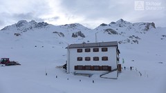


Heidelberger Hütte is a mountain hut in the Fimbatal Valley on Silvretta, not far from the Swiss border. Close to the enormous resort of Ischgl, you can also get to the chalet from the cable car station Piz Val Gronda. The Heidelberger Hütte is also accessible via the ski slopes and a prepared road from Ischgl (Snowcat taxi can be ordered). Lighter and moderate tours to Piz Tasna, Schnapfenspitz, Lareinfernerspitze, Heidelberger Spitze, Piz Tasna and Breite Krone. For the Silvretta crossing to the Jamtal Hütte, use the Schnapfenspitze route, or Kronenjoch for unstable conditions.
Tours starting from hut
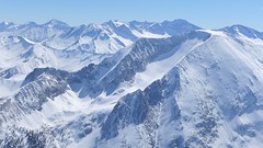
Ski tours around Hut Heidelberger Hütte
-

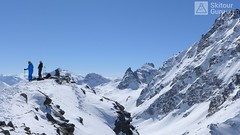
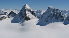
Piz Tasna from Heidelberger Hütte 3179 m
Heidelberger Hütte Silvretta Austria
- Length of ascent7 km
- ascent980 m
- duration6,5-8 h
- Fitness difficulty ♦♦♦◊
- Technical difficulty ♦♦♦◊
Piz Tasna je oblíbený vrchol oblasti kolem Heidelberger Hütte. Cesta pod horu údolím Fimbertal je velmi dlouhá. Na vrcholovém hřebeni pozor, jde o exponovaný terén. Obtížnost v závěru hodně záleží na podmínkách.

-
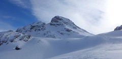
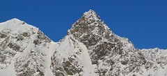
Lareinfernerspitze 3009 m
Heidelberger Hütte Silvretta Austria
- Length of ascent4 km
- ascent780 m
- duration4-5,5 h
- Fitness difficulty ♦♦◊◊
- Technical difficulty ♦♦♦◊
The Lareinfernerspitze is an interesting sightseeing ski tour on the eastern slopes above the Heidelberger hut. The ascent above the Lareinferner Joch is possible only under very stable conditions. Otherwise you climb directly from the hut (descent line).
-
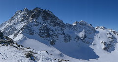
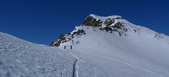
Breite Krone from Heidelberger Hütte 3071 m
Heidelberger Hütte Silvretta Austria
- Length of ascent6 km
- ascent860 m
- duration4-5,5 h
- Fitness difficulty ♦♦◊◊
- Technical difficulty ♦♦◊◊
The Breite Krone is a long, somewhat boring, ski tour through the Fimbertal. Turn right towards Kronenjoch and then slight left to the flat summit. Very quiet descent slows a short companion.
-
Schnapfenspitze NE (Heidelberger H.) 3179 m
Heidelberger Hütte Silvretta Austria
- Length of ascent5,5 km
- ascent1190 m
- duration5,5 - 7,5 h
- Fitness difficulty ♦♦♦◊
- Technical difficulty ♦♦♦◊
Relatively challenging ski tour from the Heidelberger hut. This is a lighter variant than ascent from the neighboring Jamtalhütte. First easy ascent to Lareinfernerspitze (2853 m), then descent to Lareinferner glacier and climb up a steep slope and from saddle easily to the summit. If you plan this ski tour on the last day of your stay on Heidelberger H., you can alternatively take the long Lareintal down to Tschafein and on the road to Ischgl.
- Country
- Austria
- Montains
- Silvretta
- Open (winter)
- 25.12. - mid May
- Beds
- 127
- Winterraum
- 8 beds, but closed
- Shortening of access (cableway, lift, taxi, snowcat...)
- yes, by cablecar from Piz Val Gronda / by snowcat from Ischgl
- Luggage transport
- yes, by snowcat from Ischgl (must be ordered)
- Card Pay
- no, cash only
- Shower
- yes
- Wifi
- no
- UTM / CH1903 x ("longitude" E/W)
- 32T 595943
- UTM / CH1903 y ("latitude" N/S)
- 5195891
- GPX access to hut (waipoints, track)
- HeidelbergerHut_ACCESS.gpx
- GPX all tours from the hut
- HeidelbergerHut_WPT_TRK.gpx
- Map
- Silvrettagruppe, OEAV 1:25000, Nr. 26 Tarasp, Landeskarte der Schweiz mit Skitouren 1:50000, Nr. 249 S
- Guides
- Skitourenführer Tirol / Alpinverlag, deusch Ötztal – Silvretta / Bergverlag Rother, deusch SCHITOUREN-ATLAS ÖSTERREICH WEST / Schall Verlag, deusch Graubünden Süd Skitouren / SAC-CAS, deutsch, french Engadin / Bergverlag Rother, deusch
- Phone (hut)
- +43 664 425 30 70
- Phone (valley)
- +43 664 461 89 99
- Cell phone
- -
- Mobile Signal
- yes, good
- Web
- heidelbergerhuette.at
- info@heidelberger-huette.at
- Owner of hut
- DAV Sektion Heidelberg
- Heidelberger Hütte
- Reservation
- online form
- Online reservation
- heidelbergerhuette.at
- Start Point
- Ischgl - right on Bundestrasse B188 (Paznauntalstrasse)
- UTM / CH1903 x ("longitude" E/W)
- 32T 598240
- UTM / CH1903 y ("latitude" N/S)
- 5207734
- Altitude
- 1360 m
- Ascent (height difference)
- 1000, 14km long m
- Time of Access
- 4-5 h
- Shortening lift
- yes, by snowcat from Ischgl (must be ordered)
- Start Point
- Piz Val Gronda (by cable car)
- UTM / CH1903 x ("longitude" E/W)
- 32T 598311
- UTM / CH1903 y ("latitude" N/S)
- 5197555
- Altitude
- 2812 m
- Ascent (height difference)
- only downhill m
- Time of Access
- 0,5 h
- Shortening lift
- from Ischgl, skipass necessary
- Avalanche danger
- lawine.at - Tirol
- Weather
- Heidelberger Hütte / meteoblue.com Alpenverein.at - Ostalpen Bergwetter Tirol 2 days Piz Tasna 3179m / mountain-forecast.com Paraid Naira 3015m / mountain-forecast.com Fluchthorn 3399m / mountain-forecast.com Tirol / ORF.at Austria ZAMG
- Snow report
- Ischgl / snow-forecast.com Ischgl / onthesnow.com Ischgl / bergfex.at
- Webcams
- Palinkopf 2864 (Ischgl)
- Region
- Paznaun - Ischgl
- Public traffic
- ÖBB Railway Postbus
- Skiresort nearby
- Ischgl
- Other links
- Austria Tourism
hut Heidelberger Hütte - Reviews
There are no reviews in this section yet. Click the Add Review button to add first review.
Video of ski tour
Best ski tours in mountains Silvretta, Austria
-
Piz Buin N (Wiesbadener H.) 3312 m
Wiesbadener Hütte Silvretta Austria
- Length of ascent5 km
- ascent1020 m
- duration5-6,5 h
- Fitness difficulty ♦♦◊◊
- Technical difficulty ♦♦♦♦
The ski tour to Piz Buin, the most famous Silvretta mountain in the form of a loaf is quite demanding at the end due to the exposed terrain. At the beginning on the Ochsental glacier from the Wiesbadener Hütte (or Bielerhöhe), at the end through rocky terrain. Depending on the conditions, it is advisable to secure the rope to the tricky rock.
-

Nördliche Augstenspitze Circuit 3228 m
Jamtalhütte Silvretta Austria
- Length of ascent10 km
- ascent1450 m
- duration6-8 h
- Fitness difficulty ♦♦♦◊
- Technical difficulty ♦♦♦◊
Nördliche Augstenspitze is a comprehensive and varied skitour from the Jamtalhütte. First goes to the saddle through the Chalausferner glacier to Fuorcla chalaus saddle, usually in crampons. Short descent to the Oberer Augstenferner Glacier. At the end in crampons and with ice ax to the top. A possible alternative is to extend the tour through Urezzasjoch.
-
Silvrettahorn 3244 m
Wiesbadener Hütte Silvretta Austria
- Length of ascent5 km
- ascent960 m
- duration5-6,5 h
- Fitness difficulty ♦♦♦◊
- Technical difficulty ♦♦♦◊
The ascent to the Silvrettahorn is one of the most popular excursion destinations of the Wiesbadener Hütte. After crossing the Ochsentaler Glacier, the ascent line turns right. The climb continues in the direction of Egghornlücke, but still turns right under the saddle. From the ski depot without skis over Westgrat to the summit.
Best ski tours in Austria by skitour.guru
-
Weisseck 2711 m
Zederhaus - Kirchenwirt Niedere Tauern Austria
- Length of ascent7 km
- ascent1450 m
- duration5-7 h
- Fitness difficulty ♦♦♦◊
- Technical difficulty ♦♦♦◊
Ski tour to the impressive Weisseck. In good conditions, a spectacular Ödenkar boiler descent is offered. If we don't climb to the Weisseck, the beautiful Ferskarspitze is on the way. Through the forest you reach the valley "In hell" (In der Hölle) - on one side of the rock towers, on the other side of the wall of Weisseck. Enter the Ödenkar from the upper plateau with the summit cross and watch out for snow guards and a very steep start.
-

Sulzfluh N 2818 m
Lindauer Hütte Rätikon Austria
- Length of ascent5,5 km
- ascent1300 m
- duration5-7 h
- Fitness difficulty ♦♦♦◊
- Technical difficulty ♦♦♦◊
Sulzfluh (Lindauer Hütte, Rätikon) is a very challenging ski tour through the rocky slopes "In der Rachen" (in the throat). From the top are great views of the mountains of eastern Switzerland and Silvretta.
-
Schalfkogel West (from M.Busch Hut) 3537 m
Martin-Busch-Hütte Ötztal Alps / Alpi Venoste Austria
- Length of ascent7,5 km
- ascent1200 m
- duration4,5-6 h
- Fitness difficulty ♦♦♦◊
- Technical difficulty ♦♦♦◊
Túra na Schalfkogel od chaty Martin Busch Hütte začíná sjezdem do údolí a pokračuje úzkým koridorem pod ledovcovými morénami východním směrem do sedla Schalfkogeljoch. Zde je skidepot a na vrchol v mačkách a s cepínem. Dolů po trase výstupu.