
 Česky
Česky Deutsch


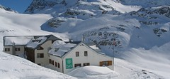


The Wiesbadener Hütte is a very popular mountain hut in the Silvretta in Vorarlberg. The disadvantage is the complicated approach - with the cable car and the buses to Bielerhöhe. Start of the ski tours on Piz Buin, Dreiländerspitze, Bugle, Rauher Kopf and Jamspitze.
Tours starting from hut
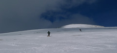
Ski tours around Hut Wiesbadener Hütte
-
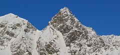
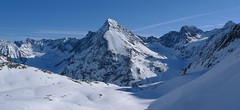
Silvrettahorn 3244 m
Wiesbadener Hütte Silvretta Austria
- Length of ascent5 km
- ascent960 m
- duration5-6,5 h
- Fitness difficulty ♦♦♦◊
- Technical difficulty ♦♦♦◊
The ascent to the Silvrettahorn is one of the most popular excursion destinations of the Wiesbadener Hütte. After crossing the Ochsentaler Glacier, the ascent line turns right. The climb continues in the direction of Egghornlücke, but still turns right under the saddle. From the ski depot without skis over Westgrat to the summit.

-

Signalhorn 3210 m
Wiesbadener Hütte Silvretta Austria
- Length of ascent5,5 km
- ascent1000 m
- duration4-5,5 h
- Fitness difficulty ♦♦♦◊
- Technical difficulty ♦♦♦◊
Signalhorn je lyžařská túra, která vede přes ledovec Ochsentaler Gletscher a sedlo Fuorcla dal Cunfin. V závěru jednoduché lezení po hřebenu na vrchol.
-

Dreiländerspitze NW (Wiesbadener H.) 3197 m
Wiesbadener Hütte Silvretta Austria
- Length of ascent3,5 km
- ascent750 m
- duration4-5,5 h
- Fitness difficulty ♦♦♦◊
- Technical difficulty ♦♦♦♦
The ski tour to peak Dreiländerspitze is initially unpretentious. Climb from Wiesbadener Hut to the Ochsenscharte. Further unpleasant traverse to the rocky ridge. Skidepo - fitting crampons and ice axe, ascent alternately on both sides of the ridge to the top. There are several climbing steps just before the summit. Back along the ascent route.
-
Piz Buin N (Wiesbadener H.) 3312 m
Wiesbadener Hütte Silvretta Austria
- Length of ascent5 km
- ascent1020 m
- duration5-6,5 h
- Fitness difficulty ♦♦◊◊
- Technical difficulty ♦♦♦♦
The ski tour to Piz Buin, the most famous Silvretta mountain in the form of a loaf is quite demanding at the end due to the exposed terrain. At the beginning on the Ochsental glacier from the Wiesbadener Hütte (or Bielerhöhe), at the end through rocky terrain. Depending on the conditions, it is advisable to secure the rope to the tricky rock.
-
Vordere/Hintere Jamspitze NW 3107 m
Wiesbadener Hütte Silvretta Austria
- Length of ascent6 km
- ascent1020 m
- duration4,5-6 h
- Fitness difficulty ♦♦◊◊
- Technical difficulty ♦♦◊◊
The Jamspitze is a very popular ski tour that is accessible from the Jamtalhütte and the Wiesbadener Hütte. One easily reaches the Ochsenscharte, then descent and climbs up to the Jamjoch. From here both Jamspitzen are heading for the summit.
-

Haagspitze West (Wiesbadener H.) 3029 m
Wiesbadener Hütte Silvretta Austria
- Length of ascent3 km
- ascent590 m
- duration2,5-4 h
- Fitness difficulty ♦♦◊◊
- Technical difficulty ♦♦◊◊
-

Rauher Kopf 3033 m
Wiesbadener Hütte Silvretta Austria
- Length of ascent3 km
- ascent690 m
- duration3-4 h
- Fitness difficulty ♦♦◊◊
- Technical difficulty ♦♦◊◊
Rauher Kopf is the ideal destination for the last day at the Wiesbadener Hütte, because it promises a perfect descent to the Bielerhöhe. The conclusion of the otherwise easy ascent is without skis, relatively easy terrain, between boulders.
- Country
- Austria
- Montains
- Silvretta
- Open (winter)
- mid February - end April
- Beds
- 170
- Winterraum
- open, 20 beds
- Shortening of access (cableway, lift, taxi, snowcat...)
- yes, by cable car und bus from Partenen to Bielerhöhe
- Luggage transport
- yes, on request from Bielerhöhe
- Card Pay
- no
- Shower
- yes
- Wifi
- no
- UTM / CH1903 x ("longitude" E/W)
- 32T 585055
- UTM / CH1903 y ("latitude" N/S)
- 5191112
- GPX access to hut (waipoints, track)
- Wiesbadenerhuette_access.gpx
- GPX all tours from the hut
- Silvretta_Wiesbadenerhuette_ALL.gpx
- Map
- Silvrettagruppe, OEAV 1:25000, Nr. 26 Tarasp, Landeskarte der Schweiz mit Skitouren 1:50000, Nr. 249 S
- Guides
- Skitourenführer Tirol / Alpinverlag, deusch Ötztal – Silvretta / Bergverlag Rother, deusch SCHITOUREN-ATLAS ÖSTERREICH WEST / Schall Verlag, deusch Graubünden Süd Skitouren / SAC-CAS, deutsch, french
- Phone (hut)
- 0043/5558/4233
- Phone (valley)
- 0043/5443/20039
- Cell phone
- -
- Mobile Signal
- yes
- Web
- wiesbadener-huette.com
- info@wiesbadener-huette.com
- Owner of hut
- DAV Sektion Wiesbaden
- Wiesbadener Hütte
- Reservation
- online form
- Online reservation
- alpsonline.org
- Start Point
- Partenen - cable car station
- UTM / CH1903 x ("longitude" E/W)
- 32T 580390
- UTM / CH1903 y ("latitude" N/S)
- 5202201
- Altitude
- 1030 m
- Ascent (height difference)
- 480 m
- Time of Access
- 1,5 - 2 h
- Shortening lift
- yes, by cable car und bus from Partenen to Bielerhöhe
- Start Point
- Bielerhöhe / Wirl
- UTM / CH1903 x ("longitude" E/W)
- 32T 583542
- UTM / CH1903 y ("latitude" N/S)
- 5196609
- Altitude
- 2035 m
- Ascent (height difference)
- 800 m
- Time of Access
- 3-4 h
- Shortening lift
- no
- Avalanche danger
- lawine.at
- Weather
- Wiesbadener Hütte / meteoblue.com Alpenverein.at - Ostalpen Bergwetter Vorarlberg 2 days Bielerhöhe / meteoblue.com Piz Buin / mountain-forecast.com Dreiländerspitze / mountain-forecast.com Vorarlberg / ORF.at Austria ZAMG
- Snow report
- Galtür / snow-forecast.com Galtür / onthesnow.com Galtür / bergfex.at
- Webcams
- Bielerhöhe Galtür - Ballunspitzbahn Jamtalhütte 3x Galtür - Dorf Palinkopf 2864 (Ischgl)
- Region
- Paznaun - Ischgl Silvretta - Montafon
- Public traffic
- ÖBB Railway Postbus
- Skiresort nearby
- Skigebiet Galtür / Paznaun-Ischgl Ischgl
- Other links
- Austria Tourism
hut Wiesbadener Hütte - Reviews
There are no reviews in this section yet. Click the Add Review button to add first review.
Best ski tours in mountains Silvretta, Austria
-

Piz Buin SE (Tuoihütte) 3312 m
Tuoi Chamonna / Tuoihütte Silvretta Switzerland
- Length of ascent5,5 km
- ascent1170 m
- duration5,5-7 h
- Fitness difficulty ♦♦♦◊
- Technical difficulty ♦♦♦◊
Piz Buin ze švýcarské strany je zajímavější túra než ze strany rakouské. výstup v závěrečné části je stejný. Pod stěnu vede trasa přes sedla Plan Mezdi a Fuorcla dal Cunfin. Za stabilní sněhové pokrývky je alternativou sjezd žlabem Buinlücke.
-

Vordere/ Hintere Jamspitze SW 3155 m
Tuoi Chamonna / Tuoihütte Silvretta Switzerland
- Length of ascent km
- ascent910 m
- duration3-4 h
- Fitness difficulty ♦♦◊◊
- Technical difficulty ♦♦◊◊
-

Piz Tasna from Heidelberger Hütte 3179 m
Heidelberger Hütte Silvretta Austria
- Length of ascent7 km
- ascent980 m
- duration6,5-8 h
- Fitness difficulty ♦♦♦◊
- Technical difficulty ♦♦♦◊
Piz Tasna je oblíbený vrchol oblasti kolem Heidelberger Hütte. Cesta pod horu údolím Fimbertal je velmi dlouhá. Na vrcholovém hřebeni pozor, jde o exponovaný terén. Obtížnost v závěru hodně záleží na podmínkách.
Best ski tours in Austria by skitour.guru
-
Schrankogel 3497 m
Amberger Hütte Stubai Alps Austria
- Length of ascent6,5 km
- ascent1300 m
- duration4-6 h
- Fitness difficulty ♦♦♦◊
- Technical difficulty ♦♦♦♦
Schrankogel je impozantní vrchol Stubaiských Alp v oblasti Amberger Hütte. Poměrně snadný nástup na úpatí, odtud na mačkách po místy exponovaném hřebenu na vrchol.
-

Westliche Simonyspitze 3488 m
Essener-Rostocker Hütte Venedigergruppe - Hohe Tauern Austria
- Length of ascent5 km
- ascent1400 m
- duration6,5-8,5 h
- Fitness difficulty ♦♦♦◊
- Technical difficulty ♦♦♦◊
Westliche Simonyspitze is a great alpine ski tour with a view of the Dreiherrnspitze. First, it rises to Reggentörl. Short downhill and follow the Umbalkees Glacier up. The ascent to the top is usually without skis. Downhill is great especially for firn.
-
Preber 2736 m
Tamsweg - Lungau Niedere Tauern Austria
- Length of ascent7 km
- ascent1200 m
- duration4,5-6 h
- Fitness difficulty ♦♦◊◊
- Technical difficulty ♦♦◊◊
Preber je velmi oblíbená vyhlídková túra nad městečkem Tamsweg. Je to jedna z nejširších skialpových sjezdovek v Alpách. Díky jižnímu svahu se lyžuje často po firnu. Z parkoviště od jezera Prebersee postupujete lesem nahoru po sáňkařské cestě. Od chaty Preberhaltehütte už pokračujete širokým svahem pod vrchol. Ke kříži krátký výstup bez lyží. Sjezd po trase výstupu.