
 Česky
Česky Deutsch


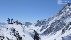


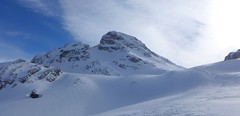
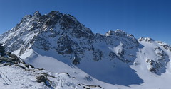
The Lareinfernerspitze is an interesting sightseeing ski tour on the eastern slopes above the Heidelberger hut. The ascent above the Lareinferner Joch is possible only under very stable conditions. Otherwise you climb directly from the hut (descent line).
Peak
- Country
- Austria
- Montains
- Silvretta
- Tags
- Austria Heidelberger Hütte Silvretta Tirol
- Hut
- Heidelberger Hütte
- UTM / CH1903 x ("longitude" E/W)
- 32T 593962
- UTM / CH1903 y ("latitude" N/S)
- 5195408
Start point
- Start Point
- Heidelberger Hütte
- Altitude
- 2266 m
- UTM / CH1903 x ("longitude" E/W)
- 32T 595943
- UTM / CH1903 y ("latitude" N/S)
- 5195891
- village, valley
- Fimbertal
- cableway / lift
- yes, from Ischgl to Piz Val Gronda
Conditions
- Avalanche danger
- lawine.at - Tirol
- Weather
- Heidelberger Hütte / meteoblue.com Alpenverein.at - Ostalpen Bergwetter Tirol 2 days Piz Tasna 3179m / mountain-forecast.com Paraid Naira 3015m / mountain-forecast.com Fluchthorn 3399m / mountain-forecast.com Tirol / ORF.at Austria ZAMG
- Snow report
- Ischgl / snow-forecast.com Ischgl / onthesnow.com Ischgl / bergfex.at
- Webcams
- Palinkopf 2864 (Ischgl)
Ski tour map on Lareinfernerspitze


 bivakovací nouzová chata
  cepín a mačky potřeba
 exponovaný, obtížný terén
 horská chata
 hôtel, penzion
 lanovka, vlek
 lavinové nebezpečí, svah > 30°
 ledovcové trhliny
 lehká túra
 mimořádně obtížná túra
 mírně obtížná túra
 obtížná túra
 parkoviště
 přístup k chatě
 restaurace
 sedlo
sedlo sjezd
sjezd skidepo
 vrchol
 výstup
 začátek ledovce
- bivouac, winter room
- crampons & ice axe necessary
- exposed, difficulty terrain
- mountain hut, refuge
- hotel, pension
- cableway, skilift
- avalanche danger, slope > 30°
- glacier cracks
- little difficult tour
- extremely difficult tour
- rather difficult tour
- difficult tour
- parking
- hut acces
- restaurant
- col, pass, saddle
- descent
- skidepot
- peak, summit
- ascent
- glacier beginning
- biwak, winterraum
- steigeisen & pickel erforderlich
- ausgesetzt, schwierige gelände
- berghütte
- hotel, pension
- seilbahn, skilift
- lawinengefahr, hangneigung > 30°
- gletscherspalten
- wenig schwierige tour
- äusserst schwierige tour
- ziemlich schwierige tour
- schwierige tour
- parkplatz
- zugang zur hütte
- restaurant
- sattel, joch, pass
- abfahrt
- skidepot
- gipfel
- aufsieg
- gletscher anfang
- bivacco, locale invernale
- ramponi & piccozza necessari
- esposto, terreno difficolt?
- rifugio, capanna
- alberghi, pensione
- funivia, seggiovia
- pericolo di valanghe, pendenza > 30°
- crepe glacier
- tour piccolo difficile
- tour estremamente difficile
- tour piuttosto difficile
- escursioni difficili
- parcheggio
- accesso capanna
- ristorante
- col, sella, passo, forcella
- discesa
- sci deposito
- picco, vertice, piz
- salita
- inizio ghiacciaio
- bivouac, local d'hiver
- crampons & piolet nécessaire
- exposée, difficulté du terrain
- cabane de montagne, refuge
- hôtel, pension
- téléphérique, téléski
- danger d'avalanche, pente > 30°
- crevasse du glacier
- peu difficile tour
- extr?mement difficile tournée
- assez difficile tour
- difficile tournée
- parking
- acces cabane
- restaurant
- col, selle
- descente
- skis dépôt
- pic, sommet
- ascension
- début glacier
- < 20°
- 20° - 25°
- 25° - 30°
- 30° - 35°
- 35° - 40°
- > 40°
Current weather conditions in the tour area
Planning of ski tour
- Fitness difficulty
-
- ♦♦◊◊
- Technical difficulty
-
- ♦♦♦◊
- best time for this tour
- March-April
- Glacier
- No
- Map
- Silvrettagruppe, OEAV 1:25000, Nr. 26 Tarasp, Landeskarte der Schweiz mit Skitouren 1:50000, Nr. 249 S
- Guides
- Skitourenführer Tirol / Alpinverlag, deusch Ötztal – Silvretta / Bergverlag Rother, deusch SCHITOUREN-ATLAS ÖSTERREICH WEST / Schall Verlag, deusch Graubünden Süd Skitouren / SAC-CAS, deutsch, french Engadin / Bergverlag Rother, deusch
About Ski tour
- Time difficulty
- Ascent (height difference)
- 780 m
- Lenght of ascent
- 4 km
- Descent (height difference)
- 780 m
- Total Lenght of tour
- 7 km
- Total time of the tour
- 4-5,5 h
- Elevation Range
- 2208 - 3009 m
- Principal Aspect
- E, SE S-south, N-north, W-west, E-east
Download
- GPX (track only)
- LarainfernerSp-TRACK.gpx best for display on a detailed topographical map (mapy.cz) or in apps for smartphones (Locus, Garmin Connect, etc.)
- GPX (waipoints, track)
- LarainfernerSpitz_skitour.gpx great for uploading in GPS device
- KML (with POI)
- LareinfernerSpitze_3009_skitour.kml for viewing in the Google Earth 3D map application, which you can install on your PC
Video of tour on Lareinfernerspitze
tour Lareinfernerspitze - Reviews
There are no reviews in this section yet. Click the Add Review button to add first review.
Ski tours around Hut Heidelberger Hütte, in mountains Silvretta, Austria
-
Breite Krone from Heidelberger Hütte 3071 m
Heidelberger Hütte Silvretta Austria
- Length of ascent6 km
- ascent860 m
- duration4-5,5 h
- Fitness difficulty ♦♦◊◊
- Technical difficulty ♦♦◊◊
The Breite Krone is a long, somewhat boring, ski tour through the Fimbertal. Turn right towards Kronenjoch and then slight left to the flat summit. Very quiet descent slows a short companion.

-
Schnapfenspitze NE (Heidelberger H.) 3179 m
Heidelberger Hütte Silvretta Austria
- Length of ascent5,5 km
- ascent1190 m
- duration5,5 - 7,5 h
- Fitness difficulty ♦♦♦◊
- Technical difficulty ♦♦♦◊
Relatively challenging ski tour from the Heidelberger hut. This is a lighter variant than ascent from the neighboring Jamtalhütte. First easy ascent to Lareinfernerspitze (2853 m), then descent to Lareinferner glacier and climb up a steep slope and from saddle easily to the summit. If you plan this ski tour on the last day of your stay on Heidelberger H., you can alternatively take the long Lareintal down to Tschafein and on the road to Ischgl.
-

Piz Tasna from Heidelberger Hütte 3179 m
Heidelberger Hütte Silvretta Austria
- Length of ascent7 km
- ascent980 m
- duration6,5-8 h
- Fitness difficulty ♦♦♦◊
- Technical difficulty ♦♦♦◊
Piz Tasna je oblíbený vrchol oblasti kolem Heidelberger Hütte. Cesta pod horu údolím Fimbertal je velmi dlouhá. Na vrcholovém hřebeni pozor, jde o exponovaný terén. Obtížnost v závěru hodně záleží na podmínkách.
Best ski tours in Silvretta by skitour.guru
-

Vordere/ Hintere Jamspitze SW 3155 m
Tuoi Chamonna / Tuoihütte Silvretta Switzerland
- Length of ascent km
- ascent910 m
- duration3-4 h
- Fitness difficulty ♦♦◊◊
- Technical difficulty ♦♦◊◊
-

Piz Buin SE (Tuoihütte) 3312 m
Tuoi Chamonna / Tuoihütte Silvretta Switzerland
- Length of ascent5,5 km
- ascent1170 m
- duration5,5-7 h
- Fitness difficulty ♦♦♦◊
- Technical difficulty ♦♦♦◊
Piz Buin ze švýcarské strany je zajímavější túra než ze strany rakouské. výstup v závěrečné části je stejný. Pod stěnu vede trasa přes sedla Plan Mezdi a Fuorcla dal Cunfin. Za stabilní sněhové pokrývky je alternativou sjezd žlabem Buinlücke.
-

Nördliche Augstenspitze Circuit 3228 m
Jamtalhütte Silvretta Austria
- Length of ascent10 km
- ascent1450 m
- duration6-8 h
- Fitness difficulty ♦♦♦◊
- Technical difficulty ♦♦♦◊
Nördliche Augstenspitze is a comprehensive and varied skitour from the Jamtalhütte. First goes to the saddle through the Chalausferner glacier to Fuorcla chalaus saddle, usually in crampons. Short descent to the Oberer Augstenferner Glacier. At the end in crampons and with ice ax to the top. A possible alternative is to extend the tour through Urezzasjoch.