
 Česky
Česky Deutsch


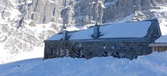


The Fridolinshütte is the most visited hut in the Glarner Alps, because everyone wants to reach the summit of the Tödi. Classic stone chalet, accessible both from the cable car to Fisetengrat and from Tierfed (Linthal).
Tours starting from hut
Ski tours around Hut Fridolinshütte

- Country
- Switzerland
- Montains
- Glarus Alps
- Open (winter)
- mid March - end May
- Beds
- 55
- Winterraum
- open, 5 beds
- Shortening of access (cableway, lift, taxi, snowcat...)
- by cableway from Urnerboden to Fisetengrat
- Luggage transport
- no
- Card Pay
- no
- Shower
- no
- Wifi
- no
- UTM / CH1903 x ("longitude" E/W)
- 715334
- UTM / CH1903 y ("latitude" N/S)
- 186687
- GPX access to hut (waipoints, track)
- Fridolins-Hut_all_access_skitour.gpx
- GPX access to hut (track only)
- Fridolin-Hut_access.gpx
- Map
- Klausenpass 246 S, Swisstopo 1:50000 Tödi, Landeskarte Schweiz Nr. 1193, 1:25000
- Guides
- Skitouren.Glarus St. Gallen / SAC Verlag, deutsch Die klassischen Skitouren / SAC-CAS.ch, deutsch Das perfekte Skitouren-Wochenende / Bergverlag Rother, deutsch
- find current conditions and experiences on the spot
- gipfelbuch.ch
- Phone (hut)
- +41 55 643 34 34
- Phone (valley)
- -
- Cell phone
- -
- Mobile Signal
- yes
- Web
- fridolinshuette.ch
- lisahoesli@bluewin.ch
- Owner of hut
- SAC Tödi
- Reservation
- e-mail, lisahoesli@bluewin.ch
- Start Point
- Fisetengrat
- UTM / CH1903 x ("longitude" E/W)
- 8.931649
- UTM / CH1903 y ("latitude" N/S)
- 193737
- Altitude
- 2026 m
- Ascent (height difference)
- 850 m
- Time of Access
- 4-5 h
- Shortening lift
- by cableway from Urnerboden to Fisetengrat
- Start Point
- Linthal - Tierfed
- UTM / CH1903 x ("longitude" E/W)
- 8.980175
- UTM / CH1903 y ("latitude" N/S)
- 193147
- Altitude
- 805 m
- Ascent (height difference)
- 1510 m
- Time of Access
- 4-5,5 h
- Shortening lift
- yes, by Taxi from Linthal to snowline
- Avalanche danger
- slf.ch - Institut für Schnee- und Lawinenforschung
- Weather
- Claridenhütte 2543m, yr.no Claridenfirn 2696m, meteoblue.com Clariden 3267m / mountain-forecast.com Gross Schärhorn 3294m / mountain-forecast.com Tödi 3614m / mountain-forecast.com Alpenverein.at - Wetter in den Alpen meteo.ch - all Switzerland srf.ch - all Switzerland Disentis 3000, snow-forecast.com
- Snow report
- Disentis 3000, snow-forecast.com Disentis 3000, bergfex.ch Disentis 3000 / onthesnow.com Disentis / snow.myswitzerland.com
- Webcams
- Claridenhütte Planurahütte
- Region
- Urnerboden Linthal Seilbahn Urnerboden-Fisetengrat
- Public traffic
- SBB Railway Postauto.ch - bus
- Skiresort nearby
- Disentis 3000
- Other links
- Switzerland Tourism
hut Fridolinshütte - Reviews
There are no reviews in this section yet. Click the Add Review button to add first review.
Best ski tours in mountains Glarus Alps, Switzerland
-

Clariden E, from Claridenhütte 3267 m
Claridenhütte Glarus Alps Switzerland
- Length of ascent6 km
- ascent1025 m
- duration4,5-6 h
- Fitness difficulty ♦♦◊◊
- Technical difficulty ♦♦◊◊
After Tödi, Clariden is the second most popular ski tour in the Glarus Alps. The ascent leads along the gentle Claridenfirn glacier from Claridenhütte to the foot of Clariden and then through a wide northeast slope to the top pyramid. Beautiful views of the entire Glarus Alps and the neighboring Uri Alps. Descent copies the ascent track. A popular alternative is to continue crossing the Planura hut after descending the steep slope turn right to Claridenpass.

-
Clariden S, from Planurahütte 3267 m
Planurahütte Glarus Alps Switzerland
- Length of ascent3,5 km
- ascent495 m
- duration4,5-6 h
- Fitness difficulty ♦♦◊◊
- Technical difficulty ♦♦◊◊
From the Planura panorama hut, Clariden is an attractive and relatively close destination. Height difference of only 500 m and no complicated passages. Over the Claridenpass glacier saddle to the Claridenfirn glacier and down the slope. In the Claridenpass saddle, you can occasionally observe modified passenger planes on skis to land in the snow.
-
Gross Schärhorn 3324 m
Planurahütte Glarus Alps Switzerland
- Length of ascent6 km
- ascent970 m
- duration6-8 h
- Fitness difficulty ♦♦♦◊
- Technical difficulty ♦♦♦◊
The Gross Schärhorn is a striking mountain with a peak in the form of open scissors. Accessible from the Planura hut, first descend the Hüfifirn glacier. From the foot of the Schärhorn on the southeast slope upwards, in places steeper than 30°. It is advantageous to combine the ski tour with the great descent to Urnerboden. First you have to ascend to the Chammlijoch saddle (3004 m) and then enjoy the descent to the Klausen pass on the northern slopes and continue to the Urnerboden (parking, public transport).
Best ski tours in Switzerland by skitour.guru
-

Tour du Ciel - day 3 3649 m
Cabane du Mountet Walliser Alpen / Alpes valaisannes Switzerland
- Length of ascent10,5 km
- ascent2420 m
- duration10-12 h
- Fitness difficulty ♦♦♦♦
- Technical difficulty ♦♦♦♦
A very long and demanding, royal stage of this Haute Route. In my opinion, the most impressive stage of all multi-day Alpine crossings. Due to the elevation gain and time required, it’s worth considering splitting the stage into two days with an overnight stay in Zinal. The long, exposed ridge to the summit requires rope protection depending on conditions. The descent is fantastically long, but caution is needed – there are large crevasses. This ski tour is only recommended in stable weather; in poor conditions, it’s advisable to bypass the Blanc de Moming via the Glacier de Zinal and ascend directly to the Cabane de Tracuit.
-

Isentällispitz 2985 m
Davos Albula Alps Switzerland
- Length of ascent4 km
- ascent1050 m
- duration3-4,5 h
- Fitness difficulty ♦♦◊◊
- Technical difficulty ♦♦◊◊
Isentällispitz is another enjoyable ski tour starting in the Flüelatal valley. From the Tschuggen parking lot, ascend over wide slopes to the saddle, where the ski depot is located. From there, continue with crampons to the panoramic summit. The descent follows the ascent route.
-

Col Valpelline, Day 6 H.R. Chamonix-Zermatt 3551 m
Cabane des Vignettes Walliser Alpen / Alpes valaisannes Switzerland
- Length of ascent9 km
- ascent1485 m
- duration8-10 h
- Fitness difficulty ♦♦♦◊
- Technical difficulty ♦♦♦◊
The last stage of the Haute Route Chamonix - Zermatt is an ode to skiing. After an easy ascent to three saddles - Col de Eveque, Col du Mont Brulé and Col Valpelline. Every ski mountaineer will be amazed by the panorama of the impressive 4000m peaks - Dent Blanche, Matterhorn and Dent d´Hérens. This is followed by a 10 km descent to Zermatt.