
 Česky
Česky Deutsch


The Planura hut was built at a spectacular viewpoint. You just have to experience it! The majestic Tödi and the big glacier on the other side. Ski tours to Clariden and Gross Schärhorn and then descent from the Chammlijoch saddle to Urnerboden. On the way to the Fridolinshütte you will also experience a great freeride on the Sandfirn glacier.
Tours starting from hut
Ski tours around Hut Planurahütte
-
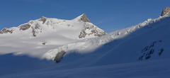
Gross Schärhorn 3324 m
Planurahütte Glarus Alps Switzerland
- Length of ascent6 km
- ascent970 m
- duration6-8 h
- Fitness difficulty ♦♦♦◊
- Technical difficulty ♦♦♦◊
The Gross Schärhorn is a striking mountain with a peak in the form of open scissors. Accessible from the Planura hut, first descend the Hüfifirn glacier. From the foot of the Schärhorn on the southeast slope upwards, in places steeper than 30°. It is advantageous to combine the ski tour with the great descent to Urnerboden. First you have to ascend to the Chammlijoch saddle (3004 m) and then enjoy the descent to the Klausen pass on the northern slopes and continue to the Urnerboden (parking, public transport).

-
Clariden S, from Planurahütte 3267 m
Planurahütte Glarus Alps Switzerland
- Length of ascent3,5 km
- ascent495 m
- duration4,5-6 h
- Fitness difficulty ♦♦◊◊
- Technical difficulty ♦♦◊◊
From the Planura panorama hut, Clariden is an attractive and relatively close destination. Height difference of only 500 m and no complicated passages. Over the Claridenpass glacier saddle to the Claridenfirn glacier and down the slope. In the Claridenpass saddle, you can occasionally observe modified passenger planes on skis to land in the snow.
- Country
- Switzerland
- Montains
- Glarus Alps
- Open (winter)
- mid March - early May
- Beds
- 41
- Winterraum
- open, 8 beds
- Shortening of access (cableway, lift, taxi, snowcat...)
- by cableway from Urnerboden to Fisetengrat
- Luggage transport
- no
- Card Pay
- no
- Shower
- no
- Wifi
- no
- UTM / CH1903 x ("longitude" E/W)
- 710019
- UTM / CH1903 y ("latitude" N/S)
- 186444
- GPX access to hut (waipoints, track)
- Planura-Hut_all_access_skitour.gpx
- GPX access to hut (track only)
- Planurahuette-access.gpx
- Map
- Klausenpass 246 S, Swisstopo 1:50000 Tödi, Landeskarte Schweiz Nr. 1193, 1:25000
- Guides
- Skitouren.Glarus St. Gallen / SAC Verlag, deutsch Die klassischen Skitouren / SAC-CAS.ch, deutsch Das perfekte Skitouren-Wochenende / Bergverlag Rother, deutsch
- find current conditions and experiences on the spot
- gipfelbuch.ch
- Phone (hut)
- +41 41 885 16 65
- Phone (valley)
- -
- Cell phone
- +41 (0)79 405 51 12
- Mobile Signal
- yes, but outside the hut
- Web
- planurahuette.ch
- info@planurahuette.ch
- Owner of hut
- SAC Tödi
- Planurahütte 2947 müM
- Reservation
- phone
- Start Point
- Fisetenpass
- UTM / CH1903 x ("longitude" E/W)
- 8.931649
- UTM / CH1903 y ("latitude" N/S)
- 193737
- Altitude
- 2036 m
- Ascent (height difference)
- 1300 m
- Time of Access
- 5-6 h
- Shortening lift
- by cableway from Urnerboden to Fisetenpass
- Start Point
- Urnerboden - Oberst Weg
- UTM / CH1903 x ("longitude" E/W)
- 710268
- UTM / CH1903 y ("latitude" N/S)
- 193324
- Altitude
- 1440 m
- Ascent (height difference)
- 1870 m
- Time of Access
- 6-7 h
- Shortening lift
- no
- Avalanche danger
- slf.ch - Institut für Schnee- und Lawinenforschung
- Weather
- Claridenpass/Planurahütte, meteoblue.com Disentis 3000, snow-forecast.com Clariden 3267m / mountain-forecast.com Gross Schärhorn 3294m / mountain-forecast.com Tödi 3614m / mountain-forecast.com Alpenverein.at - Wetter in den Alpen meteo.ch - all Switzerland srf.ch - all Switzerland
- Snow report
- Disentis 3000, snow-forecast.com Disentis 3000, bergfex.ch Disentis 3000 / onthesnow.com Disentis / snow.myswitzerland.com
- Webcams
- Planurahütte
- Region
- Urnerboden Linthal Seilbahn Urnerboden-Fisetengrat
- Public traffic
- SBB Railway Postauto.ch - bus
- Skiresort nearby
- Disentis 3000
- Other links
- Switzerland Tourism
hut Planurahütte - Reviews
There are no reviews in this section yet. Click the Add Review button to add first review.
Best ski tours in mountains Glarus Alps, Switzerland
-

Tödi 3614 m
Fridolinshütte Glarus Alps Switzerland
- Length of ascent6 km
- ascent1495 m
- duration7-10 h
- Fitness difficulty ♦♦♦◊
- Technical difficulty ♦♦♦♦
In the Middle Ages, Tödi was considered the highest mountain in the world. Today it is an attractive destination for ski mountaineers, but it is not easy to hit good weather. The ascent is made difficult by a glacier littered with fractures and cracks. Starts from the Fridolins hut over the moraine and descends briefly to the Bifertenfirn glacier. The hardest part is to overcome the first two drops, then the climb up is relatively easy. Depending on the conditions on skis or with crampons to the summit. Provides information about the current conditions on the glacier in the Fridolinshütte.
-

Clariden E, from Claridenhütte 3267 m
Claridenhütte Glarus Alps Switzerland
- Length of ascent6 km
- ascent1025 m
- duration4,5-6 h
- Fitness difficulty ♦♦◊◊
- Technical difficulty ♦♦◊◊
After Tödi, Clariden is the second most popular ski tour in the Glarus Alps. The ascent leads along the gentle Claridenfirn glacier from Claridenhütte to the foot of Clariden and then through a wide northeast slope to the top pyramid. Beautiful views of the entire Glarus Alps and the neighboring Uri Alps. Descent copies the ascent track. A popular alternative is to continue crossing the Planura hut after descending the steep slope turn right to Claridenpass.
Best ski tours in Switzerland by skitour.guru
-

Piz Bernina 4048 m
Chamanna Boval / Bovalhütte Bernina Alps Switzerland
- Length of ascent7,5 km
- ascent1695 m
- duration8-10,5 h
- Fitness difficulty ♦♦♦♦
- Technical difficulty ♦♦♦♦
Piz Bernina is the only 4000m peak in the Eastern Alps. The greatest danger are the huge and numerous crevasses on the Morteratsch Glacier and the ridge to the summit. Piz Bernina sets off from Chamanna Boval or Rifugio Marco e Rosa on the plateau below the summit. Bernina is a demanding alpine challenge.
-

Piz d´Err 3378 m
Chamanna Jenatsch / Jenatschhütte Albula Alps Switzerland
- Length of ascent km
- ascent m
- duration h
- Fitness difficulty ♦♦◊◊
- Technical difficulty ♦♦◊◊
Piz d´Err is a popular ski tour to the panoramic summit. The technically undemanding ski tour begins in Chamanna Jenatsch. The only steep section is climbing on the summit. A first class experience is under stable conditions the descent to the opposite side, western slopes to Surselva, more precisely to the village Sur, a total of 1,800 m.
-

Vordere/ Hintere Jamspitze SW 3155 m
Tuoi Chamonna / Tuoihütte Silvretta Switzerland
- Length of ascent km
- ascent910 m
- duration3-4 h
- Fitness difficulty ♦♦◊◊
- Technical difficulty ♦♦◊◊