
 Česky
Česky Deutsch


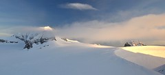


From the Planura panorama hut, Clariden is an attractive and relatively close destination. Height difference of only 500 m and no complicated passages. Over the Claridenpass glacier saddle to the Claridenfirn glacier and down the slope. In the Claridenpass saddle, you can occasionally observe modified passenger planes on skis to land in the snow.
Peak
- Country
- Switzerland
- Montains
- Glarus Alps
- Tags
- Glarner Alpen Glarus Schweiz Switzerland Uri Zentralschweiz
- Hut
- Planurahütte
- Other Huts
- Claridenhütte
- UTM / CH1903 x ("longitude" E/W)
- 709260
- UTM / CH1903 y ("latitude" N/S)
- 188878
Start point
- Start Point
- Planurahütte
- Altitude
- 2947 m
- UTM / CH1903 x ("longitude" E/W)
- 710019
- UTM / CH1903 y ("latitude" N/S)
- 186444
- cableway / lift
- no
Conditions
- Avalanche danger
- slf.ch - Institut für Schnee- und Lawinenforschung
- Weather
- Claridenpass/Planurahütte, meteoblue.com Disentis 3000, snow-forecast.com Clariden 3267m / mountain-forecast.com Gross Schärhorn 3294m / mountain-forecast.com Tödi 3614m / mountain-forecast.com Alpenverein.at - Wetter in den Alpen meteo.ch - all Switzerland srf.ch - all Switzerland
- Snow report
- Disentis 3000, snow-forecast.com Disentis 3000, bergfex.ch Disentis 3000 / onthesnow.com Disentis / snow.myswitzerland.com
- Webcams
- Planurahütte
Ski tour map on Clariden S, from Planurahütte


 bivakovací nouzová chata
  cepín a mačky potřeba
 exponovaný, obtížný terén
 horská chata
 hôtel, penzion
 lanovka, vlek
 lavinové nebezpečí, svah > 30°
 ledovcové trhliny
 lehká túra
 mimořádně obtížná túra
 mírně obtížná túra
 obtížná túra
 parkoviště
 přístup k chatě
 restaurace
 sedlo
sedlo sjezd
sjezd skidepo
 vrchol
 výstup
 začátek ledovce
- bivouac, winter room
- crampons & ice axe necessary
- exposed, difficulty terrain
- mountain hut, refuge
- hotel, pension
- cableway, skilift
- avalanche danger, slope > 30°
- glacier cracks
- little difficult tour
- extremely difficult tour
- rather difficult tour
- difficult tour
- parking
- hut acces
- restaurant
- col, pass, saddle
- descent
- skidepot
- peak, summit
- ascent
- glacier beginning
- biwak, winterraum
- steigeisen & pickel erforderlich
- ausgesetzt, schwierige gelände
- berghütte
- hotel, pension
- seilbahn, skilift
- lawinengefahr, hangneigung > 30°
- gletscherspalten
- wenig schwierige tour
- äusserst schwierige tour
- ziemlich schwierige tour
- schwierige tour
- parkplatz
- zugang zur hütte
- restaurant
- sattel, joch, pass
- abfahrt
- skidepot
- gipfel
- aufsieg
- gletscher anfang
- bivacco, locale invernale
- ramponi & piccozza necessari
- esposto, terreno difficolt?
- rifugio, capanna
- alberghi, pensione
- funivia, seggiovia
- pericolo di valanghe, pendenza > 30°
- crepe glacier
- tour piccolo difficile
- tour estremamente difficile
- tour piuttosto difficile
- escursioni difficili
- parcheggio
- accesso capanna
- ristorante
- col, sella, passo, forcella
- discesa
- sci deposito
- picco, vertice, piz
- salita
- inizio ghiacciaio
- bivouac, local d'hiver
- crampons & piolet nécessaire
- exposée, difficulté du terrain
- cabane de montagne, refuge
- hôtel, pension
- téléphérique, téléski
- danger d'avalanche, pente > 30°
- crevasse du glacier
- peu difficile tour
- extr?mement difficile tournée
- assez difficile tour
- difficile tournée
- parking
- acces cabane
- restaurant
- col, selle
- descente
- skis dépôt
- pic, sommet
- ascension
- début glacier
- < 20°
- 20° - 25°
- 25° - 30°
- 30° - 35°
- 35° - 40°
- > 40°
Current weather conditions in the tour area
Planning of ski tour
- Fitness difficulty
-
- ♦♦◊◊
- Technical difficulty
-
- ♦♦◊◊
- best time for this tour
- March-early May
- Glacier
- Yes
- Map
- Klausenpass 246 S, Swisstopo 1:50000 Tödi, Landeskarte Schweiz Nr. 1193, 1:25000
- Guides
- Skitouren.Glarus St. Gallen / SAC Verlag, deutsch Die klassischen Skitouren / SAC-CAS.ch, deutsch Das perfekte Skitouren-Wochenende / Bergverlag Rother, deutsch
- find current conditions and experiences on the spot
- gipfelbuch.ch
About Ski tour
- Time difficulty
- Ascent (height difference)
- 495 m
- Lenght of ascent
- 3,5 km
- Descent (height difference)
- 495 m
- Total Lenght of tour
- 7 km
- Total time of the tour
- 4,5-6 h
- Elevation Range
- 2910 - 3267 m
- Principal Aspect
- S, E, NE S-south, N-north, W-west, E-east
Download
- GPX (track only)
- Clariden-Planura-TRK.gpx best for display on a detailed topographical map (mapy.cz) or in apps for smartphones (Locus, Garmin Connect, etc.)
- GPX (waipoints, track)
- Clariden-skitour.gpx great for uploading in GPS device
- KML (with POI)
- Clariden_PlanuraHut_skitour.kml for viewing in the Google Earth 3D map application, which you can install on your PC
Current avalanche potential on tour - Clariden S, from Planurahütte

tour Clariden S, from Planurahütte - Reviews
There are no reviews in this section yet. Click the Add Review button to add first review.
Ski tours around Hut Planurahütte, in mountains Glarus Alps, Switzerland
Best ski tours in Glarus Alps by skitour.guru
-

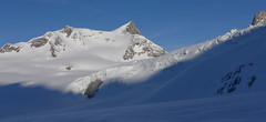
Clariden E, from Claridenhütte 3267 m
Claridenhütte Glarus Alps Switzerland
- Length of ascent6 km
- ascent1025 m
- duration4,5-6 h
- Fitness difficulty ♦♦◊◊
- Technical difficulty ♦♦◊◊
After Tödi, Clariden is the second most popular ski tour in the Glarus Alps. The ascent leads along the gentle Claridenfirn glacier from Claridenhütte to the foot of Clariden and then through a wide northeast slope to the top pyramid. Beautiful views of the entire Glarus Alps and the neighboring Uri Alps. Descent copies the ascent track. A popular alternative is to continue crossing the Planura hut after descending the steep slope turn right to Claridenpass.

-

Tödi 3614 m
Fridolinshütte Glarus Alps Switzerland
- Length of ascent6 km
- ascent1495 m
- duration7-10 h
- Fitness difficulty ♦♦♦◊
- Technical difficulty ♦♦♦♦
In the Middle Ages, Tödi was considered the highest mountain in the world. Today it is an attractive destination for ski mountaineers, but it is not easy to hit good weather. The ascent is made difficult by a glacier littered with fractures and cracks. Starts from the Fridolins hut over the moraine and descends briefly to the Bifertenfirn glacier. The hardest part is to overcome the first two drops, then the climb up is relatively easy. Depending on the conditions on skis or with crampons to the summit. Provides information about the current conditions on the glacier in the Fridolinshütte.