
 Česky
Česky Deutsch


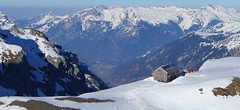


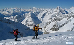
The Claridenhütte is a beautifully located mountain hut below the Gemsfairenstock in the Glarner Alps. Starting point for a ski tour on Clariden or the traverse to the Planura hut. The most advantageous approach is with the support of the cable car via Fisetengrat. It is also possible to climb from Linthal to the hut. The Clariden hut was renovated and expanded in 2013.
Tours starting from hut
Ski tours around Hut Claridenhütte

- Country
- Switzerland
- Montains
- Glarus Alps
- Open (winter)
- March - early May
- Beds
- 75
- Winterraum
- open, 12 beds
- Shortening of access (cableway, lift, taxi, snowcat...)
- by cableway from Urnerboden to Fisetengrat
- Luggage transport
- no
- Card Pay
- no
- Shower
- no
- Wifi
- no
- UTM / CH1903 x ("longitude" E/W)
- 714148
- UTM / CH1903 y ("latitude" N/S)
- 190899
- GPX access to hut (waipoints, track)
- Clariden-Hut_all_access.gpx
- GPX access to hut (track only)
- Clariden-Hut_access_TRK.gpx
- Map
- Klausenpass 246 S, Swisstopo 1:50000 Tödi, Landeskarte Schweiz Nr. 1193, 1:25000
- Guides
- Skitouren.Glarus St. Gallen / SAC Verlag, deutsch Die klassischen Skitouren / SAC-CAS.ch, deutsch Das perfekte Skitouren-Wochenende / Bergverlag Rother, deutsch
- find current conditions and experiences on the spot
- gipfelbuch.ch
- Phone (hut)
- +41 55 6433121
- Phone (valley)
- -
- Cell phone
- -
- Mobile Signal
- yes
- Web
- claridenhuette.ch
- info@claridenhuette.ch
- Owner of hut
- SAC Bachtel
- Reservation
- phone
- Start Point
- Fisetenpass
- UTM / CH1903 x ("longitude" E/W)
- 8.931649
- UTM / CH1903 y ("latitude" N/S)
- 193737
- Altitude
- 2026 m
- Ascent (height difference)
- 850 m
- Time of Access
- 3-4 h
- Shortening lift
- yes, cableway from Urnerboden to Fisetengrat
- Start Point
- Linthal - Tierfehd
- UTM / CH1903 x ("longitude" E/W)
- 8.980175
- UTM / CH1903 y ("latitude" N/S)
- 193147
- Altitude
- 805 m
- Ascent (height difference)
- 1760 m
- Time of Access
- 5-6 h
- Shortening lift
- no
- Avalanche danger
- slf.ch - Institut für Schnee- und Lawinenforschung
- Weather
- Claridenhütte 2543m, yr.no Claridenfirn 2696m, meteoblue.com Clariden 3267m / mountain-forecast.com Gross Schärhorn 3294m / mountain-forecast.com Tödi 3614m / mountain-forecast.com Alpenverein.at - Wetter in den Alpen meteo.ch - all Switzerland srf.ch - all Switzerland Disentis 3000, snow-forecast.com
- Snow report
- Disentis 3000, snow-forecast.com Disentis 3000, bergfex.ch Disentis 3000 / onthesnow.com Disentis / snow.myswitzerland.com
- Webcams
- Claridenhütte Planurahütte
- Region
- Urnerboden Linthal Seilbahn Urnerboden-Fisetengrat
- Public traffic
- SBB Railway Postauto.ch - bus
- Skiresort nearby
- Disentis 3000
- Other links
- Switzerland Tourism
hut Claridenhütte - Reviews
There are no reviews in this section yet. Click the Add Review button to add first review.
Best ski tours in mountains Glarus Alps, Switzerland
-

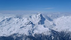
Tödi 3614 m
Fridolinshütte Glarus Alps Switzerland
- Length of ascent6 km
- ascent1495 m
- duration7-10 h
- Fitness difficulty ♦♦♦◊
- Technical difficulty ♦♦♦♦
In the Middle Ages, Tödi was considered the highest mountain in the world. Today it is an attractive destination for ski mountaineers, but it is not easy to hit good weather. The ascent is made difficult by a glacier littered with fractures and cracks. Starts from the Fridolins hut over the moraine and descends briefly to the Bifertenfirn glacier. The hardest part is to overcome the first two drops, then the climb up is relatively easy. Depending on the conditions on skis or with crampons to the summit. Provides information about the current conditions on the glacier in the Fridolinshütte.

-
Gross Schärhorn 3324 m
Planurahütte Glarus Alps Switzerland
- Length of ascent6 km
- ascent970 m
- duration6-8 h
- Fitness difficulty ♦♦♦◊
- Technical difficulty ♦♦♦◊
The Gross Schärhorn is a striking mountain with a peak in the form of open scissors. Accessible from the Planura hut, first descend the Hüfifirn glacier. From the foot of the Schärhorn on the southeast slope upwards, in places steeper than 30°. It is advantageous to combine the ski tour with the great descent to Urnerboden. First you have to ascend to the Chammlijoch saddle (3004 m) and then enjoy the descent to the Klausen pass on the northern slopes and continue to the Urnerboden (parking, public transport).
-
Clariden S, from Planurahütte 3267 m
Planurahütte Glarus Alps Switzerland
- Length of ascent3,5 km
- ascent495 m
- duration4,5-6 h
- Fitness difficulty ♦♦◊◊
- Technical difficulty ♦♦◊◊
From the Planura panorama hut, Clariden is an attractive and relatively close destination. Height difference of only 500 m and no complicated passages. Over the Claridenpass glacier saddle to the Claridenfirn glacier and down the slope. In the Claridenpass saddle, you can occasionally observe modified passenger planes on skis to land in the snow.
Best ski tours in Switzerland by skitour.guru
-

Col Valpelline, Day 6 H.R. Chamonix-Zermatt 3551 m
Cabane des Vignettes Walliser Alpen / Alpes valaisannes Switzerland
- Length of ascent9 km
- ascent1485 m
- duration8-10 h
- Fitness difficulty ♦♦♦◊
- Technical difficulty ♦♦♦◊
The last stage of the Haute Route Chamonix - Zermatt is an ode to skiing. After an easy ascent to three saddles - Col de Eveque, Col du Mont Brulé and Col Valpelline. Every ski mountaineer will be amazed by the panorama of the impressive 4000m peaks - Dent Blanche, Matterhorn and Dent d´Hérens. This is followed by a 10 km descent to Zermatt.
-
Grosser Aletschhorn 4189 m
Oberaletschhütte Berner Alpen / Alpes bernoises Switzerland
- Length of ascent7 km
- ascent1750 m
- duration7-9 h
- Fitness difficulty ♦♦♦♦
- Technical difficulty ♦♦♦◊
Grosser Aletschhorn is lonely 4000 in the middle of the Berner Alps in Switzerland over the Oberaletschgletscher and the hut of the same name. From the top views of the Wallis Alps, including the Matterhorn.
-
Piz Platta 3392 m
Mulegns - Posthotel Löwen Platta Group / Oberhalbstein Switzerland
- Length of ascent11 km
- ascent1980 m
- duration8-11 h
- Fitness difficulty ♦♦♦♦
- Technical difficulty ♦♦♦◊
Impressive very long ski tour on the more pronounced Piz Platta summit in the Plattagruppe-Oberhalbstein mountain group. Aproach from the village of Mulengs - road from Tiefencastel to Julierpass. First a few kilometers through the forest, then left at the foot of the mountain and then constantly up the northeast slope to the plateau (ski depot). Next you have to climb the southern slope to the top plateau with crampons and ice axe.