
 Česky
Česky Deutsch


The mountain hut Fornohütte, Italian Capanna del Forno, is located in the rocky part of the Bernina mountain group, in the Bregaglia region. From the hut, you start from the Maloja Pass at the namesake village in the canton of Graubünden. The modernized hut sits on a sunny terrace above the Forno glacier. Longer hikes into the back of the valley lead to Cima Cantun, Monte Sissoni, and Cima Rosso. A beautiful circular hike culminates at Monte Rosso, and above the hut rises Monte del Forno. A great option for the last day is the tour from Fornohütte to the summit of Pizzi dei Rossi, featuring a long descent down to Maloja Pass
Tours starting from hut
Ski tours around Hut Fornohütte - Capanna del Forno
-

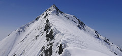
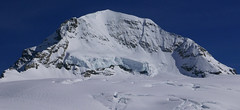
Cima dal Cantun 3346 m
Fornohütte - Capanna del Forno Bernina Alps Switzerland
- Length of ascent7 km
- ascent1220 m
- duration4,5-6 h
- Fitness difficulty ♦♦♦◊
- Technical difficulty ♦♦◊◊
Poměrně dlouhá ledovcová túry v oblasti Forno. Po výstupu přes ledovec Vadrec del Forno (pozor na trhliny) směrem na Passo dal Cantun. Skialpový vrchol túry ja na začátku vrcholového hřebenu.

-
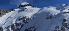
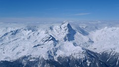
Monte Sissone 3328 m
Fornohütte - Capanna del Forno Bernina Alps Switzerland
- Length of ascent8 km
- ascent1225 m
- duration4,5-6 h
- Fitness difficulty ♦♦♦◊
- Technical difficulty ♦♦◊◊
Túra na Monte Sissone je velkolepým krajinářským zážitkem. Nad ledovci zdobí krajinu granitové skály Bergellu. Od chaty se sjede na ledovec Forno a v závěru údolí se stoupá pohodlně do sedla Passo Sissone. Odtud už to není daleko na samotný špičatý vrchol. Krásný výhled na protější Cima Rosso a hlavně nejvyšší Piz Bernina i impozantní Monte Disgrazia.
-

Pizzi dei Rossi 3026 m
Fornohütte - Capanna del Forno Bernina Alps Switzerland
- Length of ascent3 km
- ascent665 m
- duration4,5-6 h
- Fitness difficulty ♦♦◊◊
- Technical difficulty ♦♦♦♦
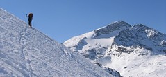
Skialpová Pizzi dei Rossi je ideální volbou pro poslední den na chatě. Návrat na parkoviště pod Malojapassem má úplně jinou úroveň, než přesun údolím. Výstup z chaty vede často traverzy zápaního svahu, na jaře jsou haršajsny nutností. Náročný je až výstup prudkým svahem do sedla, většinou bude nutné nasadit mačky a lyže dát batoh. Ze sedla nalehko a bez lyží na vrchol. Sjezd severním kuloárem je zprvu velmi prudký a bmusí se projet zúžením mezi skalami. Dál po pláních je už luxusní svah a když je dobrý sníh, je to fantastický sjezd. Ten pokračuje i údolím Val Muretto až na planinu Canis. Pár krátkých protisvahů na kraj soutěsky a pak už zase jen dolů k mostu přes horskou bystřinu a po rovině na parkoviště.
-

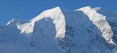
Cima di Rosso 3365 m
Fornohütte - Capanna del Forno Bernina Alps Switzerland
- Length of ascent7,5 km
- ascent1255 m
- duration4,5-6 h
- Fitness difficulty ♦♦♦◊
- Technical difficulty ♦♦♦◊
Cima di Rosso je skialpová klasika v oblasti Forno. Ledovcová túra s vynikajícim výhledem na Munt Disgrazia a Piz Bernina. Kromě sjezdu po trase výstupu je možná sjezdová alernativa severním svahem, kde bývá často prašan.
-

Monte Rosso 3088 m
Fornohütte - Capanna del Forno Bernina Alps Switzerland
- Length of ascent4 km
- ascent840 m
- duration4-5,5 h
- Fitness difficulty ♦♦◊◊
- Technical difficulty ♦♦♦◊
Skvělým skialpovým vrcholem uprostřed oblasti je Monte Rosso. Výhodou okruhu je maximalistický krajinářský zážitek. Po výstupu do dvou sedel se otevřou vždy nové výhledy. Od chaty míříme nejprve do sedla Sella del Forno. Koukáme na Berninu a dolů na skiresort Valmalenco. Krásným kotlem po krátkém sjezdu traverujeme a míříme nahoru do druhého sedla – Passo di Val Bona. Po strmějším svahu do místa na skalním hřebenu, kde je skidepot. Odtud v mačkách na vrchol. Na lyžích parádní sjezd jihozápadním svahem na ledovec Forno a zpět nahoru k chatě.
-
Monte del Forno 3213 m
Fornohütte - Capanna del Forno Bernina Alps Switzerland
- Length of ascent2,5 km
- ascent660 m
- duration3,5-5 h
- Fitness difficulty ♦♦◊◊
- Technical difficulty ♦♦♦◊
Poměrně náročná túra na vrchol se stejným jménem jako chata. Nejprve snadný výstup do sedla Sella di Forno. Odtud doleva prudkými svahy až ke skalám, kde je skidepot. Po skalách s pomocí řetězů opět na zasněžený svah a po něm na vrchol.
- Country
- Switzerland
- Montains
- Bernina Alps
- Open (winter)
- March - April
- Beds
- 75
- Winterraum
- yes, 4 beds
- Shortening of access (cableway, lift, taxi, snowcat...)
- no
- Luggage transport
- no
- Card Pay
- yes
- Shower
- no
- Wifi
- no
- UTM / CH1903 x ("longitude" E/W)
- 774829
- UTM / CH1903 y ("latitude" N/S)
- 133684
- GPX access to hut (waipoints, track)
- FornoHut_access.gpx
- GPX access to hut (track only)
- Fornohuette_Access_TRK.gpx
- GPX all tours from the hut
- Fornohuette_ALL_skitours.gpx
- Map
- 1296 Sciora, Swisstopo 1:25000 1277 Val Bregaglia, Swisstopo 1:25000 S268 Julierpass, Swisstopo 1:50000
- Guides
- Graubünden Süd / SAC-CAS.ch, deutsch
- Phone (hut)
- +41 81 824 31 82
- Phone (valley)
- -
- Cell phone
- -
- Mobile Signal
- no
- Web
- fornohuette.ch
- info@fornohuette.ch
- Owner of hut
- SAC Rorschach
- Fornohütte SAC
- Reservation
- online
- Online reservation
- alpsonline.org
- Start Point
- Maloja Pass View Parking
- UTM / CH1903 x ("longitude" E/W)
- 773374
- UTM / CH1903 y ("latitude" N/S)
- 140598
- Altitude
- 1800 m
- Ascent (height difference)
- 955 m
- Time of Access
- 3,5-4,5 h
- Shortening lift
- no
- Avalanche danger
- slf.ch - Institut für Schnee- und Lawinenforschung
- Weather
- Monte Forno 3214m / meteoblue.com Cima di Rosso 3366m / srf.ch Monte Forno 3214m / ventusky.com Cima di Rosso 3366m / mountain-forecast.com Cima Cantun 3354m / mountain-forecast.com Monte Forno 3214m / mountain-forecast.com Piz Bacun 3244m / mountain-forecast.com Il Chapütschin 3388m / meteoblue.com Cima di Rosso 3366m / kachelmannwetter.com Corvatsch-Furtschellas / snow-forecast.com Switzerland - animation / srf.ch Alpenvereinswetter
- Snow report
- Corvatsch-Furtschellas / snow-forecast.com St. Moritz / onthesnow.com Diavolezza - Lagalb / bergfex.ch St. Moritz / snow.myswitzerland.com
- Webcams
- All webcams around St. Moritz Meteoblue.com - webcams around
- Region
- Graubünden Engadin St. Moritz Maloja
- Public traffic
- SBB Railway Postauto.ch - bus
- Skiresort nearby
- Corvatsch - Furtschellas
- Other links
- Switzerland Tourism
hut Fornohütte - Capanna del Forno - Reviews
There are no reviews in this section yet. Click the Add Review button to add first review.
Best ski tours in mountains Bernina Alps, Switzerland
-

Piz Bernina 4048 m
Chamanna Boval / Bovalhütte Bernina Alps Switzerland
- Length of ascent7,5 km
- ascent1695 m
- duration8-10,5 h
- Fitness difficulty ♦♦♦♦
- Technical difficulty ♦♦♦♦
Piz Bernina is the only 4000m peak in the Eastern Alps. The greatest danger are the huge and numerous crevasses on the Morteratsch Glacier and the ridge to the summit. Piz Bernina sets off from Chamanna Boval or Rifugio Marco e Rosa on the plateau below the summit. Bernina is a demanding alpine challenge.
-
Piz Surlej - Piz San Gian 3187 m
St. Moritz Bernina Alps Switzerland
- Length of ascent4 km
- ascent990 m
- duration4-6 h
- Fitness difficulty ♦♦◊◊
- Technical difficulty ♦♦♦◊
Piz Surlej and Piz San Gian is an interesting ski tour over two neighboring peaks. In the morning you take the cable car to Piz Corvatsch and enjoy the wonderful view of the Albula Alps as well as the lakes Sils and Silvaplana. Follow the ski slope to the Margun Vegl cable car station or to the upper station (2643 m). A logical line to Piz Surlej and further along the ridge to Piz San Gian. And then a spectacular descent to St. Moritz. Warning, some slopes of this ski tour have avalanche potential, especially the descent from the San Gian summit to St. Moritz. This tour is for skiers with good riding technique.
-
Piz Palü 3882 m
Diavolezza Berghaus Bernina Alps Switzerland
- Length of ascent6,5 km
- ascent1180 m
- duration6,5-8,5 h
- Fitness difficulty ♦♦♦◊
- Technical difficulty ♦♦♦◊
The Piz Palü with its characteristic three pillars is probably the most popular "not 4000" in the Alps. The exit from the Berghaus Diavolezza is ideal, it is also possible from the Bovalhütte. The key point for the ascent and descent is the passage of the Labyrinth between the Seraks. Continue over a relatively steep glacier to the ski depot. Then ascent with ice axe and crampons along the exposed summit ridge. The usual goal of ski mountaineers is the eastern summit - 3882 m.
Best ski tours in Switzerland by skitour.guru
-

La Luette 3547 m
Cabane des Dix Walliser Alpen / Alpes valaisannes Switzerland
- Length of ascent3 km
- ascent710 m
- duration1,5-3 h
- Fitness difficulty ♦♦◊◊
- Technical difficulty ♦♦◊◊
La Luette je vděčná túra z chaty Cabane Dix. Po mírném svahu na ledovec Glacier de la Luette a v závěru po hřebenu na vrchol. Pouhých 500 výškových metrů od chaty může být lákadlem pro odpolední túru poté, když dorazíte brzo na chatu Dix.
-
Mönch 4107 m
Mönchsjochhütte Berner Alpen / Alpes bernoises Switzerland
- Length of ascent2 km
- ascent525 m
- duration2,5-4 h
- Fitness difficulty ♦♦◊◊
- Technical difficulty ♦♦♦♦
Túra na impozantní Mnich (Mönch) je v podstatě dlouhou hřebenovkou v mačkách a s cepínem. S rostoucí výškou roste obtížnost. S úbytkem ledovcového příkrovu roste expozice. Pokud nejste horský vůdce, nepoužívejte techniku krátkého lana. V závěrečném úseku je každá chyba nevratná. Výstup přináší fantastický zážitek se spoustou výhledů na nádherný svět ledovců.
-
Piz Platta 3392 m
Mulegns - Posthotel Löwen Platta Group / Oberhalbstein Switzerland
- Length of ascent11 km
- ascent1980 m
- duration8-11 h
- Fitness difficulty ♦♦♦♦
- Technical difficulty ♦♦♦◊
Impressive very long ski tour on the more pronounced Piz Platta summit in the Plattagruppe-Oberhalbstein mountain group. Aproach from the village of Mulengs - road from Tiefencastel to Julierpass. First a few kilometers through the forest, then left at the foot of the mountain and then constantly up the northeast slope to the plateau (ski depot). Next you have to climb the southern slope to the top plateau with crampons and ice axe.