
 Česky
Česky Deutsch


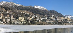


St. Moritz is a world famous winter sports resort, ideal for all types of skiing. In addition to ski tours from the surrounding mountain huts - Diavolezza, Jenatsch and Muottas Muragl - there are great ski tours to Piz San Gian and Piz Surgonda, both with the support of the cable car.
Tours starting from hut
Ski tours around Hut St. Moritz
- Country
- Switzerland
- Montains
- Bernina Alps
- Open (winter)
- Beds
- 0
- Winterraum
- Shortening of access (cableway, lift, taxi, snowcat...)
- UTM / CH1903 x ("longitude" E/W)
- 784815
- UTM / CH1903 y ("latitude" N/S)
- 152457
- Map
- 1257 St. Moritz, Swisstopo 1:25000 S268 Julierpass, Swisstopo 1:50000 2521 St. Moritz-Bernina, Swisstopo 1:25000
- Guides
- Graubünden Süd / SAC-CAS.ch, deutsch Die klassischen Skitouren / SAC-CAS.ch, deutsch Les classiques de randonnée à ski / SAC-CAS.ch, francais Engadin / Rother Skitourenführer, deutsch
- find current conditions and experiences on the spot
- gipfelbuch.ch
- Phone (hut)
- -
- Phone (valley)
- -
- Cell phone
- -
- Web
- St.Moritz
- -
- Owner of hut
- -
- St. Moritz
- Online reservation
- stmoritz.com
- Avalanche danger
- slf.ch - Institut für Schnee- und Lawinenforschung
- Weather
- St. Moritz / meteoblue.com St. Moritz / srf.ch St. Moritz / snow-forecast.com Muottas Muragl / mountain-forecast.com Piz Vadret 3199m / mountain-forecast.com Piz Julier 3380m / mountain-forecast.com Piz Surlej 3188m/ mountain-forecast.com Piz Nair 3057m / meteoblue.com Piz Corvatsch 3451m/ mountain-forecast.com St. Moritz / kachelmannwetter.com St. Moritz / wetter.com Switzerland - animation / srf.ch Alpenvereinswetter
- Snow report
- St. Moritz / snow-forecast.com St. Moritz / onthesnow.com St. Moritz - Corvatsch / bergfex.ch St. Moritz / snow.myswitzerland.com
- Webcams
- All webcams around St. Moritz - mountains Muottas Muragl Corvatsch Piz Nair All webcams St. Moritz - city
- Region
- Graubünden Engadin St. Moritz Pontresina
- Public traffic
- SBB Railway Postauto.ch - bus St. Moritz - local buses and trains St. Moritz - public transport info
- Skiresort nearby
- St. Moritz - Corviglia - Corvatsch - Diavolezza
- Other links
- Switzerland Tourism
hut St. Moritz - Reviews
There are no reviews in this section yet. Click the Add Review button to add first review.
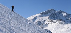
Best ski tours in mountains Bernina Alps, Switzerland
-

Monte Rosso 3088 m
Fornohütte - Capanna del Forno Bernina Alps Switzerland
- Length of ascent4 km
- ascent840 m
- duration4-5,5 h
- Fitness difficulty ♦♦◊◊
- Technical difficulty ♦♦♦◊
Skvělým skialpovým vrcholem uprostřed oblasti je Monte Rosso. Výhodou okruhu je maximalistický krajinářský zážitek. Po výstupu do dvou sedel se otevřou vždy nové výhledy. Od chaty míříme nejprve do sedla Sella del Forno. Koukáme na Berninu a dolů na skiresort Valmalenco. Krásným kotlem po krátkém sjezdu traverujeme a míříme nahoru do druhého sedla – Passo di Val Bona. Po strmějším svahu do místa na skalním hřebenu, kde je skidepot. Odtud v mačkách na vrchol. Na lyžích parádní sjezd jihozápadním svahem na ledovec Forno a zpět nahoru k chatě.

-

Piz Bernina 4048 m
Chamanna Boval / Bovalhütte Bernina Alps Switzerland
- Length of ascent7,5 km
- ascent1695 m
- duration8-10,5 h
- Fitness difficulty ♦♦♦♦
- Technical difficulty ♦♦♦♦
Piz Bernina is the only 4000m peak in the Eastern Alps. The greatest danger are the huge and numerous crevasses on the Morteratsch Glacier and the ridge to the summit. Piz Bernina sets off from Chamanna Boval or Rifugio Marco e Rosa on the plateau below the summit. Bernina is a demanding alpine challenge.
-

Cima di Rosso 3365 m
Fornohütte - Capanna del Forno Bernina Alps Switzerland
- Length of ascent7,5 km
- ascent1255 m
- duration4,5-6 h
- Fitness difficulty ♦♦♦◊
- Technical difficulty ♦♦♦◊
Cima di Rosso je skialpová klasika v oblasti Forno. Ledovcová túra s vynikajícim výhledem na Munt Disgrazia a Piz Bernina. Kromě sjezdu po trase výstupu je možná sjezdová alernativa severním svahem, kde bývá často prašan.
Best ski tours in Switzerland by skitour.guru
-

Gletscher Ducan 3019 m
Davos Albula Alps Switzerland
- Length of ascent6,5 km
- ascent1360 m
- duration5,5-7 h
- Fitness difficulty ♦♦◊◊
- Technical difficulty ♦♦♦◊
The Ducan Gletscher is a summit with a wonderful view of the Piz Kesch and especially the Piz Ela. The ski tour starts in Monstein, where the highest brewery in Europe is located. The Fanezfurgga saddle leads to valley with a striking mountain. The end of the climb up is usually with ice axe and crampons. The descent through the Ducantal valley is oriented to the north and leads skiers into the Sertigtal valley. The route can also be done in the opposite direction. It is advisable to undertake the tour with the support of public transport.
-

Piz Buin SE (Tuoihütte) 3312 m
Tuoi Chamonna / Tuoihütte Silvretta Switzerland
- Length of ascent5,5 km
- ascent1170 m
- duration5,5-7 h
- Fitness difficulty ♦♦♦◊
- Technical difficulty ♦♦♦◊
Piz Buin ze švýcarské strany je zajímavější túra než ze strany rakouské. výstup v závěrečné části je stejný. Pod stěnu vede trasa přes sedla Plan Mezdi a Fuorcla dal Cunfin. Za stabilní sněhové pokrývky je alternativou sjezd žlabem Buinlücke.
-

La Luette 3547 m
Cabane des Dix Walliser Alpen / Alpes valaisannes Switzerland
- Length of ascent3 km
- ascent710 m
- duration1,5-3 h
- Fitness difficulty ♦♦◊◊
- Technical difficulty ♦♦◊◊
La Luette je vděčná túra z chaty Cabane Dix. Po mírném svahu na ledovec Glacier de la Luette a v závěru po hřebenu na vrchol. Pouhých 500 výškových metrů od chaty může být lákadlem pro odpolední túru poté, když dorazíte brzo na chatu Dix.