
 Česky
Česky Deutsch


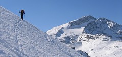
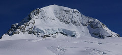
Chamanna Boval / Bovalhütte is easy to reach from Morteratsch train station (Rhätische Bahn, to Berninapass). The main goal is a ski tour to Piz Bernina, possibly Piz Palü.
Tours starting from hut

Ski tours around Hut Chamanna Boval / Bovalhütte

- Country
- Switzerland
- Montains
- Bernina Alps
- Open (winter)
- mid March - mid May
- Beds
- 90
- Winterraum
- open, 14 beds
- Shortening of access (cableway, lift, taxi, snowcat...)
- no
- Luggage transport
- no
- Card Pay
- no
- Shower
- no
- Wifi
- no
- UTM / CH1903 x ("longitude" E/W)
- 791137
- UTM / CH1903 y ("latitude" N/S)
- 143455
- GPX access to hut (waipoints, track)
- Boval-Hut_access_Morteratsch.gpx
- GPX access to hut (track only)
- Boval Chmn_access_TRK.gpx
- Map
- 1277 Piz Bernina, Swisstopo 1:25000 S268 Julierpass, Swisstopo 1:50000
- Guides
- Graubünden Süd / SAC-CAS.ch, deutsch Die klassischen Skitouren / SAC-CAS.ch, deutsch Les classiques de randonnée à ski / SAC-CAS.ch, francais Engadin / Rother Skitourenführer, deutsch
- Phone (hut)
- +41 81 842 64 03
- Phone (valley)
- -
- Cell phone
- -
- Mobile Signal
- no
- Web
- boval.ch
- boval@bluewin.ch
- Owner of hut
- SAC Bernina
- Reservation
- phone, online former
- Online reservation
- sac-bernina.ch
- Start Point
- Morteratsch Bahnhof
- UTM / CH1903 x ("longitude" E/W)
- 792200
- UTM / CH1903 y ("latitude" N/S)
- 147447
- Altitude
- 1896 m
- Ascent (height difference)
- 600 m
- Time of Access
- 2,5 - 3 h
- Shortening lift
- no
- Start Point
- Berghaus Diavolezza
- UTM / CH1903 x ("longitude" E/W)
- 794223
- UTM / CH1903 y ("latitude" N/S)
- 143181
- Altitude
- 2978 m
- Ascent (height difference)
- 100 m
- Time of Access
- 1-1,5 h
- Shortening lift
- yes, by cable car from Diavolezza-Lagalb train station to Berghaus Diavolezza
- Avalanche danger
- slf.ch - Institut für Schnee- und Lawinenforschung
- Weather
- Diavolezza / meteoblue.com Bovalhütte / srf.ch Diavolezza / snow-forecast.com Munt Pers 3207m / mountain-forecast.com Piz Bernina-La Spedla / mountain-forecast.com Piz Boval 3353m / mountain-forecast.com Piz Palü 3889m/ mountain-forecast.com Piz Palü 3889m / meteoblue.com Piz Morteratsch 3751m/ mountain-forecast.com Piz Boval / kachelmannwetter.com St. Moritz / wetter.com Switzerland - animation / srf.ch Alpenvereinswetter
- Snow report
- Diavolezza - Lagalb / snow-forecast.com St. Moritz / onthesnow.com Diavolezza - Lagalb / bergfex.ch St. Moritz / snow.myswitzerland.com
- Webcams
- All webcams around St. Moritz Diavolezza
- Region
- Graubünden Engadin St. Moritz Pontresina
- Public traffic
- SBB Railway Postauto.ch - bus
- Skiresort nearby
- St. Moritz - Corviglia - Corvatsch - Diavolezza
- Other links
- Switzerland Tourism
hut Chamanna Boval / Bovalhütte - Reviews
There are no reviews in this section yet. Click the Add Review button to add first review.
Best ski tours in mountains Bernina Alps, Switzerland
-

Cima di Rosso 3365 m
Fornohütte - Capanna del Forno Bernina Alps Switzerland
- Length of ascent7,5 km
- ascent1255 m
- duration4,5-6 h
- Fitness difficulty ♦♦♦◊
- Technical difficulty ♦♦♦◊
Cima di Rosso je skialpová klasika v oblasti Forno. Ledovcová túra s vynikajícim výhledem na Munt Disgrazia a Piz Bernina. Kromě sjezdu po trase výstupu je možná sjezdová alernativa severním svahem, kde bývá často prašan.

-
Piz Surlej - Piz San Gian 3187 m
St. Moritz Bernina Alps Switzerland
- Length of ascent4 km
- ascent990 m
- duration4-6 h
- Fitness difficulty ♦♦◊◊
- Technical difficulty ♦♦♦◊
Piz Surlej and Piz San Gian is an interesting ski tour over two neighboring peaks. In the morning you take the cable car to Piz Corvatsch and enjoy the wonderful view of the Albula Alps as well as the lakes Sils and Silvaplana. Follow the ski slope to the Margun Vegl cable car station or to the upper station (2643 m). A logical line to Piz Surlej and further along the ridge to Piz San Gian. And then a spectacular descent to St. Moritz. Warning, some slopes of this ski tour have avalanche potential, especially the descent from the San Gian summit to St. Moritz. This tour is for skiers with good riding technique.
-

Monte Rosso 3088 m
Fornohütte - Capanna del Forno Bernina Alps Switzerland
- Length of ascent4 km
- ascent840 m
- duration4-5,5 h
- Fitness difficulty ♦♦◊◊
- Technical difficulty ♦♦♦◊
Skvělým skialpovým vrcholem uprostřed oblasti je Monte Rosso. Výhodou okruhu je maximalistický krajinářský zážitek. Po výstupu do dvou sedel se otevřou vždy nové výhledy. Od chaty míříme nejprve do sedla Sella del Forno. Koukáme na Berninu a dolů na skiresort Valmalenco. Krásným kotlem po krátkém sjezdu traverujeme a míříme nahoru do druhého sedla – Passo di Val Bona. Po strmějším svahu do místa na skalním hřebenu, kde je skidepot. Odtud v mačkách na vrchol. Na lyžích parádní sjezd jihozápadním svahem na ledovec Forno a zpět nahoru k chatě.
Best ski tours in Switzerland by skitour.guru
-
Mönch 4107 m
Mönchsjochhütte Berner Alpen / Alpes bernoises Switzerland
- Length of ascent2 km
- ascent525 m
- duration2,5-4 h
- Fitness difficulty ♦♦◊◊
- Technical difficulty ♦♦♦♦
Túra na impozantní Mnich (Mönch) je v podstatě dlouhou hřebenovkou v mačkách a s cepínem. S rostoucí výškou roste obtížnost. S úbytkem ledovcového příkrovu roste expozice. Pokud nejste horský vůdce, nepoužívejte techniku krátkého lana. V závěrečném úseku je každá chyba nevratná. Výstup přináší fantastický zážitek se spoustou výhledů na nádherný svět ledovců.
-

Diechterhorn (day 3, h.r. Swiss Glacier) 3389 m
Trifthütte Urner Alps Switzerland
- Length of ascent12 km
- ascent2100 m
- duration10-12 h
- Fitness difficulty ♦♦♦♦
- Technical difficulty ♦♦♦♦
Hiking on top of fantastic lookout tower. Glacier skitour. At the end, you will reach the summit from the north, to the top of the climbing terrain. Next continue to the Diechterlimi saddle and from there a fantastic downhill run to Gelmerhütte and then to the Gelmersee dam. If the lake is not frozen, the route along the northern bank can be very challenging, depending on the snow conditions. After crossing the dam, is coming downhill, often very complicated, traversing western slope to the Grimselpass road. After that, a bit on the parking lot under the Räterichsboden dam and at first a steep traverse to Bächlihütte - a hut on the top.
-

Gletscher Ducan 3019 m
Davos Albula Alps Switzerland
- Length of ascent6,5 km
- ascent1360 m
- duration5,5-7 h
- Fitness difficulty ♦♦◊◊
- Technical difficulty ♦♦♦◊
The Ducan Gletscher is a summit with a wonderful view of the Piz Kesch and especially the Piz Ela. The ski tour starts in Monstein, where the highest brewery in Europe is located. The Fanezfurgga saddle leads to valley with a striking mountain. The end of the climb up is usually with ice axe and crampons. The descent through the Ducantal valley is oriented to the north and leads skiers into the Sertigtal valley. The route can also be done in the opposite direction. It is advisable to undertake the tour with the support of public transport.