
 Česky
Česky Deutsch


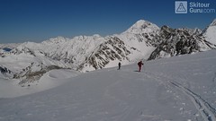
Túra na Kuhscheibe patří se středně náročným. Na vrchol se potřeba dolézt v mačkách. Krásný výhled na Ötztálské Alpy včetně střediska Sölden.
Peak
- Country
- Austria
- Montains
- Stubai Alps
- Tags
- Austria Stubai Stubaier Alpen Tirol
- Hut
- Amberger Hütte
- UTM / CH1903 x ("longitude" E/W)
- 32T 656203
- UTM / CH1903 y ("latitude" N/S)
- 5208624
Start point
- Start Point
- Amberger Hütte
- Altitude
- 2135 m
- UTM / CH1903 x ("longitude" E/W)
- 32T 657564
- UTM / CH1903 y ("latitude" N/S)
- 5211937
Conditions
- Avalanche danger
- LWD Tirol
- Weather
- Amberger Hütte - meteoblue.com Stubaier Gletscher - snow-forecast.com Gries - yr.no Schrankogel 3497m, mountain-forecast.com Ruderhofspitze 3474m, meteoblue.com yr.no - Ruderhofspitze ORF ZAMG Alpenverein.at
- Snow report
- Oetz, snow-forecast.com Gries - Längenfeld, bergfex.at Stubaier Gletscher, onthesnow.com Stubaier Gletscher, snow-forecast.com Stubaier Gletscher
- Webcams
- Franz Senn Hütte Stubai Gletscher Gries
Ski tour map on Kuhscheibe


 bivakovací nouzová chata
  cepín a mačky potřeba
 exponovaný, obtížný terén
 horská chata
 hôtel, penzion
 lanovka, vlek
 lavinové nebezpečí, svah > 30°
 ledovcové trhliny
 lehká túra
 mimořádně obtížná túra
 mírně obtížná túra
 obtížná túra
 parkoviště
 přístup k chatě
 restaurace
 sedlo
sedlo sjezd
sjezd skidepo
 vrchol
 výstup
 začátek ledovce
- bivouac, winter room
- crampons & ice axe necessary
- exposed, difficulty terrain
- mountain hut, refuge
- hotel, pension
- cableway, skilift
- avalanche danger, slope > 30°
- glacier cracks
- little difficult tour
- extremely difficult tour
- rather difficult tour
- difficult tour
- parking
- hut acces
- restaurant
- col, pass, saddle
- descent
- skidepot
- peak, summit
- ascent
- glacier beginning
- biwak, winterraum
- steigeisen & pickel erforderlich
- ausgesetzt, schwierige gelände
- berghütte
- hotel, pension
- seilbahn, skilift
- lawinengefahr, hangneigung > 30°
- gletscherspalten
- wenig schwierige tour
- äusserst schwierige tour
- ziemlich schwierige tour
- schwierige tour
- parkplatz
- zugang zur hütte
- restaurant
- sattel, joch, pass
- abfahrt
- skidepot
- gipfel
- aufsieg
- gletscher anfang
- bivacco, locale invernale
- ramponi & piccozza necessari
- esposto, terreno difficolt?
- rifugio, capanna
- alberghi, pensione
- funivia, seggiovia
- pericolo di valanghe, pendenza > 30°
- crepe glacier
- tour piccolo difficile
- tour estremamente difficile
- tour piuttosto difficile
- escursioni difficili
- parcheggio
- accesso capanna
- ristorante
- col, sella, passo, forcella
- discesa
- sci deposito
- picco, vertice, piz
- salita
- inizio ghiacciaio
- bivouac, local d'hiver
- crampons & piolet nécessaire
- exposée, difficulté du terrain
- cabane de montagne, refuge
- hôtel, pension
- téléphérique, téléski
- danger d'avalanche, pente > 30°
- crevasse du glacier
- peu difficile tour
- extr?mement difficile tournée
- assez difficile tour
- difficile tournée
- parking
- acces cabane
- restaurant
- col, selle
- descente
- skis dépôt
- pic, sommet
- ascension
- début glacier
- < 20°
- 20° - 25°
- 25° - 30°
- 30° - 35°
- 35° - 40°
- > 40°
Current weather conditions in the tour area
Planning of ski tour
- Fitness difficulty
-
- ♦♦◊◊
- Technical difficulty
-
- ♦♦◊◊
- best time for this tour
- Glacier
- Yes
- Map
- Stubaier Alpen - Hochstubai, OEAV 31/1 mit Skirouten , 1:25000
- Guides
- Schitouren-Atlas ÖSTERREICH WEST Skitourenführer Stubaier Alpen - Panico Alpinverlag
About Ski tour
- Time difficulty
- Ascent (height difference)
- 1050 m
- Lenght of ascent
- 5,5 km
- Descent (height difference)
- 1050 m
- Total Lenght of tour
- 11 km
- Total time of the tour
- 3,5-4,5 h
- Elevation Range
- 2100 - 3188 m
- Principal Aspect
- N, NW, E S-south, N-north, W-west, E-east
Download
- GPX (track only)
- Kuhscheibe_Amberger_TRK.gpx best for display on a detailed topographical map (mapy.cz) or in apps for smartphones (Locus, Garmin Connect, etc.)
- GPX (waipoints, track)
- Kuhscheibe_Amberger-Hut_skitour.gpx great for uploading in GPS device
- KML (with POI)
- Kuhscheibe_AmbergerH_skitour.kml for viewing in the Google Earth 3D map application, which you can install on your PC
Current avalanche potential on tour - Kuhscheibe

tour Kuhscheibe - Reviews
There are no reviews in this section yet. Click the Add Review button to add first review.
Ski tours around Hut Amberger Hütte, in mountains Stubai Alps, Austria
-
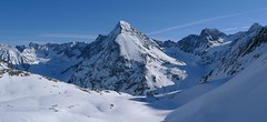
Hinterer Daunkopf (N, from Amberger H.) 3225 m
Amberger Hütte Stubai Alps Austria
- Length of ascent7 km
- ascent1100 m
- duration4-5,5 h
- Fitness difficulty ♦♦◊◊
- Technical difficulty ♦♦◊◊
Krásná túra členitým terénem po zajímavé hraně ledovce na vrchol Hinterer Daunkopf. Krásný výhled na sjezdovky střediska Stubaier Gletscher. Pozor na orientaci a hlavně stav ledovce. Sjezd po výstupové linii.

-
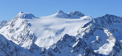
Schrankogel 3497 m
Amberger Hütte Stubai Alps Austria
- Length of ascent6,5 km
- ascent1300 m
- duration4-6 h
- Fitness difficulty ♦♦♦◊
- Technical difficulty ♦♦♦♦
Schrankogel je impozantní vrchol Stubaiských Alp v oblasti Amberger Hütte. Poměrně snadný nástup na úpatí, odtud na mačkách po místy exponovaném hřebenu na vrchol.
-

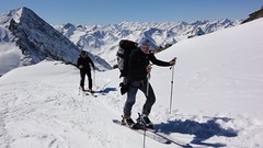
Schrankarkogel 3327 m
Amberger Hütte Stubai Alps Austria
- Length of ascent6,5 km
- ascent1310 m
- duration4-6 h
- Fitness difficulty ♦♦◊◊
- Technical difficulty ♦♦◊◊
Lyžařská túra na skalnatý vrchol Schrankarkogel nad ledovcem Schwarzenbergferner. Alternativní cíl pro ty, kdo si netroufnou na sousední a impozantní Schrankogel. Orientačně jednoduchá trasa, sjezd po trase výstupu.
Best ski tours in Stubai Alps by skitour.guru
-

Wilder Pfaff (from Hildesheimer Hütte) 3458 m
Hildesheimer Hütte Stubai Alps Austria
- Length of ascent4,5 km
- ascent700 m
- duration3-4,5 h
- Fitness difficulty ♦♦◊◊
- Technical difficulty ♦♦♦◊
Wilder Pfaff a Zuckerhütl je lákavými cíli z winterraumu chaty Hildesheimer Hütte. Prudký sjezd svahu od chaty na dno karu má velký lavinový potenciál a proto vyžaduje dodržování všech bezpečnostních opatření. Ze dna karu (2750 m) do sedla Pfaffenjoch a po plochém ledovci pod vrcholovou část.Ke kříži je většinou možné vyšlapat na lyžích. Pro sjezd existují dvě možnosti. Buď po trase výstupu zpět na chatu nebo po ledovci Sulzenauferner do údolí Stubaital. Na ledovci dávejte velký pozor na četné ledovcové trhliny.
-
Zuckerhütl (from Eisjochferner - cable car) 3505 m
Stubai - Mutterbergalm (cable car) Stubai Alps Austria
- Length of ascent5 km
- ascent960 m
- duration5,5-6,5 h
- Fitness difficulty ♦♦◊◊
- Technical difficulty ♦♦♦◊
Zuckerhütl je nejvyšší hora Stubaiských Alp. Leží nedaleko ledovcového skiresortu Stubaier Gletscherbahn. Pokud vyjedete lanovkou na nejvyšší bod střediska Eisjochferner a zatočíte po vysednutí ze sedačkové lanovky doleva k restauraci Jochdohle, začnete túru sjezdem z výšky 3150 m po ledovci Gaiskarferner. Ze dna karu (2751 m) do sedla Pfaffenjoch a po plochém ledovci pod vrcholovou pyramidu. Odtud bez lyží, v mačkách a s cepínem na vrchol. Při sjezdu po ledovci Sulzenauferner dávejte velký pozor na četné ledovcové trhliny.
-
Wildes Hinterbergl 3225 m
Franz Senn Hütte Stubai Alps Austria
- Length of ascent7 km
- ascent1141 m
- duration5-8 h
- Fitness difficulty ♦♦◊◊
- Technical difficulty ♦♦♦◊
Wildes Hinterbergl (Franz Senn Hütte, Stubaier Alpen) is the most attractive ski tour from Franz Senn Hütte. In addition, it offers two variants of the downhill. Great lookout mountain.